
filter
-
Brand
- By Category
- Direction
- Date Range
60Events
Pictures
Events

Editorial USA - 12th Annual Ed Asner & Friends Celebrity Poker Event - Studio City, Ca - 15 Jun 2024
- 2024-06-17
- 2

Editorial USA - 12th Annual Ed Asner & Friends Celebrity Poker Event - Studio City
- 2024-06-17
- 1

Editorial Funeral of Canada's former Prime Minister Brian Mulroney, in Montreal
- 2024-03-24
- 4
Editorial Funeral of Canada's former Prime Minister Brian Mulroney, in Montreal
- 2023-12-07
- 1

Editorial Funeral of Canada's former Prime Minister Brian Mulroney, in Montreal
- 2023-11-01
- 1

Editorial Funeral of Canada's former Prime Minister Brian Mulroney, in Montreal
- 2023-06-15
- 1

Editorial Funeral of Canada's former Prime Minister Brian Mulroney, in Montreal
- 2023-06-15
- 1

Editorial Funeral of Canada's former Prime Minister Brian Mulroney, in Montreal
- 2023-06-15
- 1

Editorial Cda Mexico Nals, Mexico City, Mexico - 11 Jan 2023
- 2023-01-12
- 1

Editorial Outline Map of Switzerland with the tourist's route, Map of Switzerland with inscription of the route of Forbes, to S. VIII, Wyld, J (engraved), 1852, J. Forbes: The physician's holyday or: A month in Switzerland in the summer of 1848. London, 1852.
- 2022-12-24
- 1
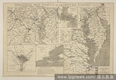
Editorial A map showing the strategic war points of the United States. Strategic War points of the United States. London : J. Wyld, [1861]. Source: Maps 71495.(42.). Language: English.
- 2022-12-24
- 1
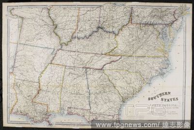
Editorial A map of the Southern States of North America, with the Forts, Harbours and Military Positions. Map of the Southern States of North America, with the Forts, Harbours and Military Positions. London : J. Wyld, [1862]. Source: Maps 71495.(59.). Language: ...
- 2022-12-24
- 1

Editorial A map showing Strategic War Points of the United States. Strategic War Points of the United States. London : J. Wyld. Source: Maps * 71495.(53.). Language: English.
- 2022-12-24
- 1
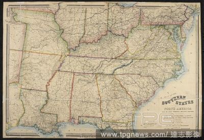
Editorial A map of the Southern States of North America. Map of the Southern States of North America, with the Forts, Harbours, and Military Positions. London : J. Wyld, [1865?]. Source: Maps 71495.(92.). Language: English.
- 2022-12-24
- 1

Editorial Manchester from Kersal Moor, with rustic figures and goats. Date/Period: 1852. Painting. Watercolour and bodycolour with gum arabic and some scraping out, over graphite on paper. Height: 319 mm (12.55 in); Width: 491 mm (19.33 in).
- 2022-04-22
- 1
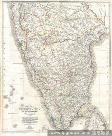
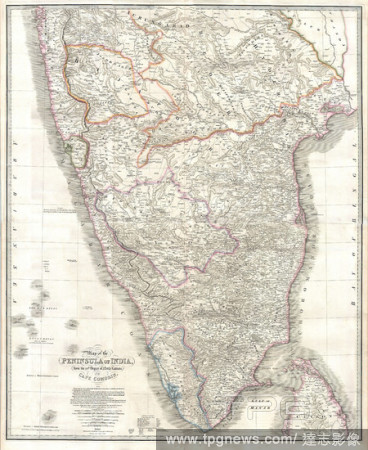
Editorial 1838, Wyld Wall Map of India, Hindostan or British India.
- 2022-01-19
- 1

Editorial 1853, Wyld Pocket or Case Map of Ireland.
- 2022-01-18
- 1
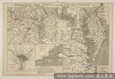
Editorial A map showing the strategic war points of the United States. Strategic War points of the United States. London : J. Wyld, [1861]. Source: Maps 71495.(42.). Language: English.
- 2021-10-09
- 1

Editorial London and Westminster. Plan of London and Westminster with the Borough of. London : J. Wyld, 1834. Plan of London and Westminster with the Borough of Southwark. Image taken from Plan of London and Westminster with the Borough of Southwark Scale, 1/2 ...
- 2021-10-09
- 1
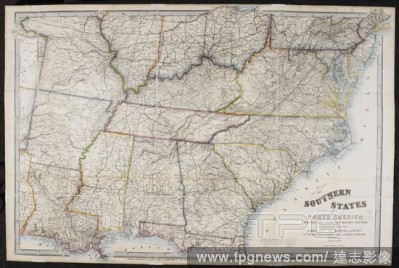
Editorial A map of the Southern States of North America, with the Forts, Harbours and Military Positions. Map of the Southern States of North America, with the Forts, Harbours and Military Positions. London : J. Wyld, [1862]. Source: Maps 71495.(59.). Language: ...
- 2021-10-09
- 1

Editorial A map of the Southern States of North America. Map of the Southern States of North America, with the Forts, Harbours, and Military Positions. London : J. Wyld, [1865?]. Source: Maps 71495.(92.). Language: English.
- 2021-10-09
- 1

Editorial !9th century map of London and Westminster, with the Borough of Southwark. it shows Regents Park and Hyde Park, also Baker Street. Plan of London and Westminster with the Borough of with the Borough of Southwark. London : J. Wyld, 1834. 1/2 a mile[ = 6...
- 2021-10-09
- 1
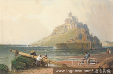
Editorial View of Mont St. Michel with Figures on the Beach, William Wyld, 18061889, British, undated, Watercolor, gouache and graphite on medium, slightly textured, cream wove paper, Sheet: 7 1/2 ? 11 1/2 inches (19.1 ? 29.2 cm).
- 2021-02-21
- 1

Editorial Ship at Sea, Attributed to William Wyld, 18061889, British, undated, Watercolor and brown ink on medium, slightly textured, cream wove paper, Sheet: 2 3/4 ? 4 inches (7 ? 10.2 cm), marine art, sea, ship, waves (natural events).
- 2021-02-21
- 1

Editorial Rome from the Palatine Hill, William Wyld, 18061889, British, undated, Graphite and watercolor on medium, slightly textured, cream wove paper, Sheet: 6 5/16 x 15 3/8 inches (16 x 39.1 cm), cityscape, Grand Tour, Rome.
- 2021-02-21
- 1
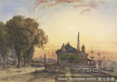
Editorial Nantes, William Wyld, 18061889, British, undated, Watercolor and gouache on moderately thick, slightly textured, cream wove paper, Sheet: 6 3/4 ? 9 5/8 inches (17.1 ? 24.4 cm), buildings, cityscape, coast, flags, Grand Tour, light, ships, sun, France, ...
- 2021-02-21
- 1

Editorial Plan of Westminster Abbey and Environs for the Coronation of George IV, James Wyld, 17901836, British, after James Wyld, 17901836, British, 1821, Engraving.
- 2021-02-21
- 1

Editorial Outline Map of Switzerland with the tourist's route, Map of Switzerland with inscription of the route of Forbes, to S. VIII, Wyld, J (engraved), 1852, J. Forbes: The physician's holyday or: A month in Switzerland in the summer of 1848. London, 1852.
- 2020-01-15
- 1
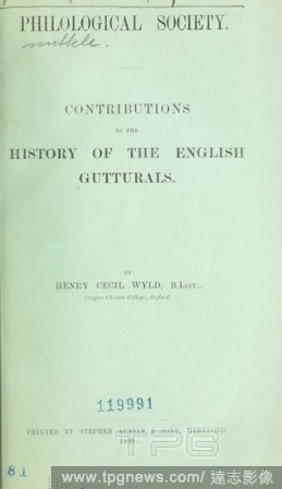
Editorial Contributions to the history of the English gutturals : Wyld, Henry Cecil Kennedy, 1870-1945.
- 2019-12-18
- 1

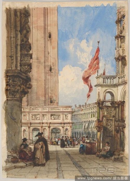
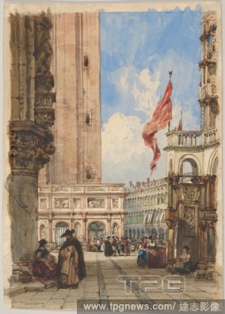
Editorial St. Mark's Square, Venice, with Loggetta.
- 2019-11-18
- 1

Editorial Bedcover (Ocean Wave Quilt), c. 1883, Made by Frances Brooks Wyld, American, died 1958, United States, Illinois, Chicago, United States, Cotton, plain weaves, printed, cotton, twill weaves, pieced, edged and backed with cotton, plain weave, quilted, 17...
- 2019-11-18
- 1

Editorial *EXCLUSIVE* Keanu Reeves and Alex Winter film 'Bill & Ted Face the Music'
- 2019-07-31
- 31
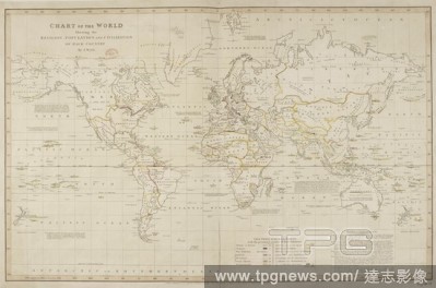
Editorial Chart of the World showing the religion, population and civilization of each country. Chart of the World showing the religion, population and civilization of each country. London, J. Hatchard, 1815. Source: Maps.950.(23).
- 2019-07-16
- 1
Editorial St. Mark's Square, Venice, with Loggetta.
- 2019-02-22
- 1

Editorial London and Westminster. Plan of London and Westminster with the Borough of. London : J. Wyld, 1834. Plan of London and Westminster with the Borough of Southwark. Image taken from Plan of London and Westminster with the Borough of Southwark Scale, 1/2 ...
- 2019-01-24
- 1

Editorial !9th century map of London and Westminster, with the Borough of Southwark. it shows Regents Park and Hyde Park, also Baker Street. Plan of London and Westminster with the Borough of with the Borough of Southwark. London : J. Wyld, 1834. 1/2 a mile[ = 6...
- 2019-01-24
- 1
Editorial 1838, Wyld Wall Map of India, Hindostan or British India.
- 2019-01-23
- 1

Editorial 1853, Wyld Pocket or Case Map of Ireland.
- 2019-01-23
- 1

Editorial A map showing the strategic war points of the United States. Strategic War points of the United States. London : J. Wyld, [1861]. Source: Maps 71495.(42.). Language: English.
- 2018-12-06
- 1
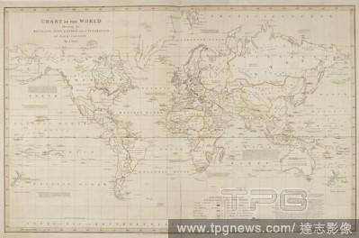
Editorial Chart of the World showing the religion, population and civilization of each country. Chart of the World showing the religion, population and civilization of each country. London, J. Hatchard, 1815. Source: Maps.950.(23).
- 2018-12-06
- 1

Editorial Ireland. An Atlas of Modern Geography ... By J. Wyld.. 1842. Ireland divided into provinces & counties. Image taken from An Atlas of Modern Geography By J. Wyld... Originally published/produced in 1842. . Source: Maps.43.b.14, 6. Language: English.
- 2018-12-06
- 1
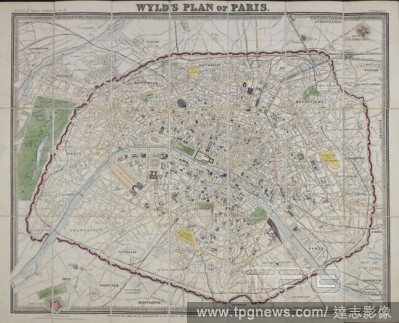
Editorial A plan of Paris, 1870. Wyld's plan of Paris / published by James Wyld. London : Published by James Wyld, Geographer to the Queen, 457 Strand, 11 & 12 Charing Cross & 2 Royal Exchange, Oct.r 29.th 1870. 1 map : col ; 57 x 71cm. Source: Maps.C.44.a.44.
- 2018-12-06
- 1

Editorial London and Greenwich railway. J. Wyld, 1832. Plan shewing the proposed line of the London and Greenwich railway. Originally published/produced in J. Wyld, 1832. . Source: Maps.Crace.19.56,.
- 2018-12-06
- 1
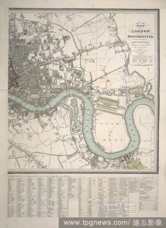
Editorial London and Westminster. Plan of London and Westminster with the Borough of. London : J. Wyld, 1834. Plan of London and Westminster with the Borough of Southwark. Image taken from Plan of London and Westminster with the Borough of Southwark Scale, 1/2 ...
- 2018-12-06
- 1

Editorial A map of the Southern States of North America, with the Forts, Harbours and Military Positions. Map of the Southern States of North America, with the Forts, Harbours and Military Positions. London : J. Wyld, [1862]. Source: Maps 71495.(59.). Language: ...
- 2018-12-06
- 1
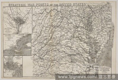
Editorial A map showing Strategic War Points of the United States. Strategic War Points of the United States. London : J. Wyld. Source: Maps * 71495.(53.). Language: English.
- 2018-12-06
- 1
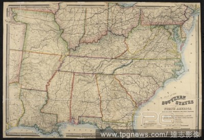
Editorial A map of the Southern States of North America. Map of the Southern States of North America, with the Forts, Harbours, and Military Positions. London : J. Wyld, [1865?]. Source: Maps 71495.(92.). Language: English.
- 2018-12-06
- 1
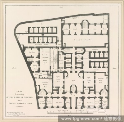
Editorial Plan for converting Giltspur Street compter into a house of correction. Plan for converting Giltspur Street compter into a house of correction. London, 1849. Source: Maps.Crace.Port.8.86. Language: English.
- 2018-12-06
- 1
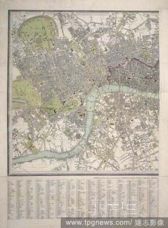
Editorial !9th century map of London and Westminster, with the Borough of Southwark. it shows Regents Park and Hyde Park, also Baker Street. Plan of London and Westminster with the Borough of with the Borough of Southwark. London : J. Wyld, 1834. 1/2 a mile[ = 6...
- 2018-12-06
- 1
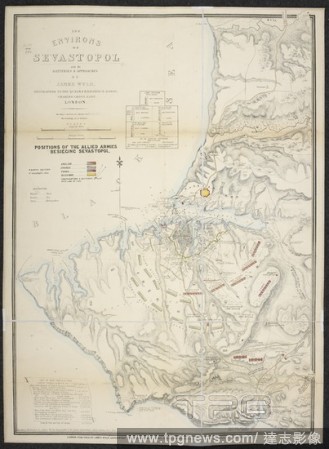
Editorial A map of the environs of Sevastopol. The Environs of Sevastopol with the Batteries and Approaches. Second edition, Oct. 10th, 1854. By J. Wyld. 4th Nov. 1854. Source: Maps 41155.(5.). Language: English.
- 2018-12-06
- 1
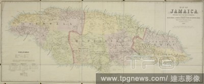
Editorial A map of Jamaica. Map of Jamaica prepared ... under the direction of Major General J.R. Mann, R.E. ... By T. Harrison, Government Surveyor. Scale, 1 : 171,000. 1881. Source: Maps 81710.(3.). Language: English.
- 2018-12-06
- 1

Editorial A plan of Nottingham. To the Most Noble Henry Pelham Clinton Duke of Newcastle ... this plan of the town of Nottingham and its environs (from a special survey) is respectfully dedicated by ... Edward W. Salmon. London, Charing Cross East : James Wyld, ...
- 2018-12-06
- 1
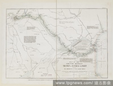
Editorial A map of the country between the Gulf of Pe-tche-li and Peking, showing the operations of the Allied Forces. Map of the country between the Gulf of Pe-tche-li and Pekin, shewing the operations of the Allied Forces. London : J. Wyld, [1860]. Source: Map...
- 2018-12-06
- 1
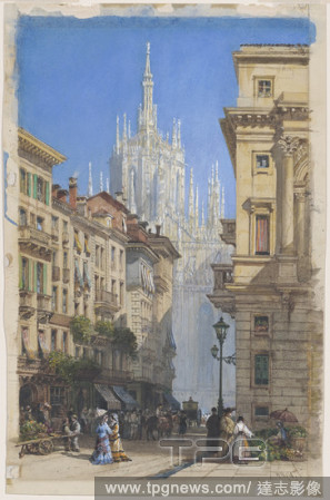
Editorial The Duomo in Milan from a Side Street. Dated: c. 1834. Dimensions: sheet: 38.6 ? 24.9 cm (15 3/16 ? 9 13/16 in.). Medium: watercolor and gouache over black chalk on wove paper.
- 2018-11-29
- 1

Editorial Manchester from Kersal Moor, with rustic figures and goats. Date/Period: 1852. Painting. Watercolour and bodycolour with gum arabic and some scraping out, over graphite on paper. Height: 319 mm (12.55 in); Width: 491 mm (19.33 in).
- 2018-10-11
- 1

Editorial The Duomo in Milan from a Side Street. Dated: c. 1834. Dimensions: sheet: 38.6 ? 24.9 cm (15 3/16 ? 9 13/16 in.). Medium: watercolor and gouache over black chalk on wove paper.
- 2018-09-18
- 1

Editorial St. Mark's Square, Venice, with Loggetta.
- 2018-08-06
- 1

Editorial 1838, Wyld Wall Map of India, Hindostan or British India.
- 2018-08-06
- 1

Editorial 1853, Wyld Pocket or Case Map of Ireland.
- 2018-08-03
- 1
 Loading