
filter
-
Brand
- By Category
- Direction
- Date Range
58Events
Pictures
Events

Editorial
- 2023-06-15
- 1

Editorial
- 2023-06-14
- 1
Editorial
- 2023-06-14
- 1
Editorial
- 2023-06-07
- 1
Editorial
- 2023-03-17
- 1
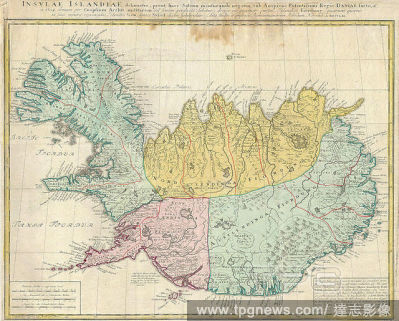
Editorial 1761, Homann Heirs Map of Iceland Insulae Islandiae.
- 2022-01-19
- 1

Editorial Map of the western part of Java, Insulae Iavae Pars Occidentalis Edente Hadriano Relando (title on object), Map of West Java and a tip of Sumatra (inks above). There are five compass roses. There are topographical details on the map: rice fields, mount...
- 2022-01-18
- 1
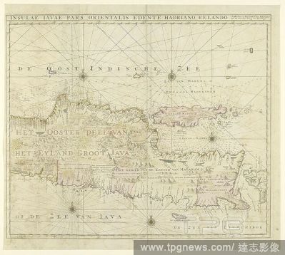
Editorial Map of the eastern part of Java, Insulae Javae pars orientalis Edinte Hadriano Relando (title on object), Map from East Java. At the top a view of Batavia from the water. There are five compass roses and topographical details have been added to the map...
- 2022-01-18
- 1

Editorial Map of Indonesia and part of Southeast Asia, India with Orientalis dicitur et Insulae adiacentes (title on object), Map of Indonesia and a part of Southeast Asia. The different areas are colored differently. In the top center on either side of the titl...
- 2020-12-04
- 1
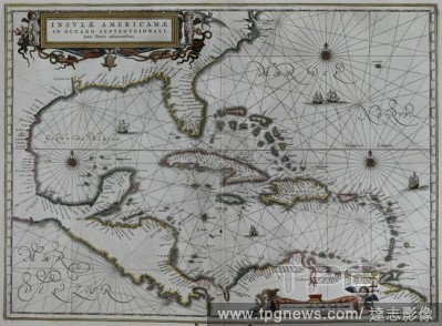
Editorial INSULAE AMERICANAE-MAPA DE AMERICA 1652.
- 2020-11-26
- 1
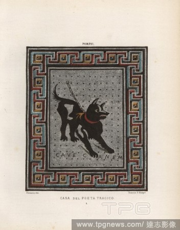
Editorial Mosaic of a guard dog on a chain from the Casa del Poeta Tragico, House of the Tragic Poet, Regio VI, Insulae 8,3,5. Illustration drawn by Discanno and lithographed by Victor Steeger from Emile Presuhn's "Choix des plus Belles et Interessantes Peinture...
- 2020-09-28
- 1

Editorial Map of the newly excavated Insulae (buildings) in Pompeii from 1874 to 1881. Map drawn by Presuhn and lithographed by J. G. Bach from Emil Presuhn's "Pompeji. Die Neuesten Ausgrabungen von 1874-1881," Weigel, Leipzig, 1882. German archeologist Presuhn ...
- 2020-09-28
- 1
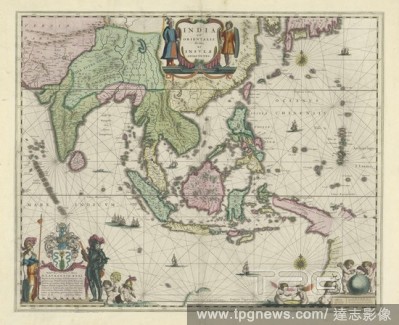
Editorial Map of Indonesia and part of Southeast Asia, India with Orientalis dicitur et Insulae adiacentes (title on object), Map of Indonesia and a part of Southeast Asia. The different areas are colored differently. In the top center on either side of the titl...
- 2020-01-15
- 1
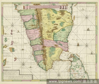
Editorial Map of South India Nova tabula terrarum Cucan, Canara, Malabaria, Madura, & Coromandella, cum parte septentrionali insulae Ceylon, in mari Indico Orientali / edente Hadriano Relando (title on object), Map of South India with a part of Ceylon, ranging f...
- 2020-01-15
- 1
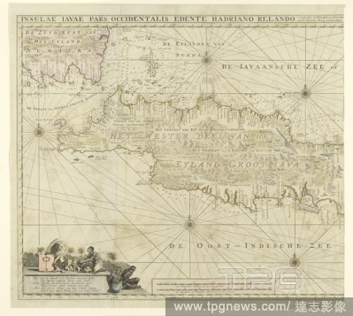
Editorial Map of the western part of Java, Insulae Iavae Pars Occidentalis Edente Hadriano Relando (title on object), Map of West Java and a tip of Sumatra (inks above). There are five compass roses. There are topographical details on the map: rice fields, mount...
- 2020-01-15
- 1
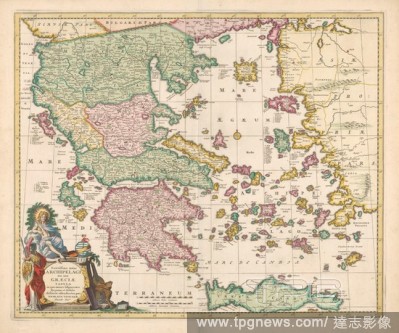
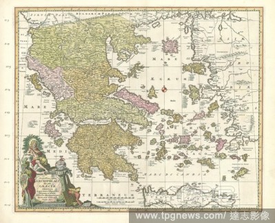
Editorial Cartography in the Netherlands, map of Greece, Map of Greece, bordered in yellow, areas colored. Compass rose in the middle, inscription l.o. surrounded by 2 allegorical figures and attributes for practicing the seven arts. M.o. scale in Italian and Ge...
- 2019-12-18
- 1
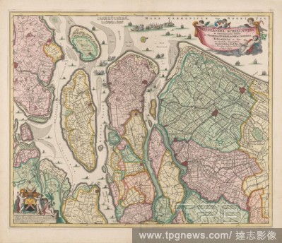
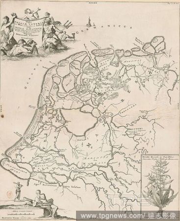
Editorial Map of South Holland, Delflandia, Schielandia and circumjacentes insulae ut Voorna, Overflackea, Gurea, Yselmonda et aliae, ex conatibus geographicis (title on object), Map from South Holland with the west above. Middle above the scale in Dutch and Fre...
- 2019-12-18
- 1
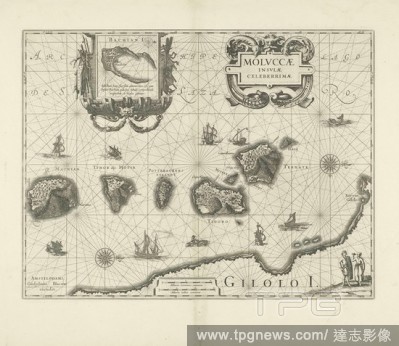
Editorial Map of some islands of the Moluccas Moluccae insulae celeberrimae (title on object), Map of islands of the Moluccas, top left of Bachian I (Batjan). Two compass roses. The north is on the right, in the sea ships and sea monsters, at the bottom right a ...
- 2019-12-18
- 1
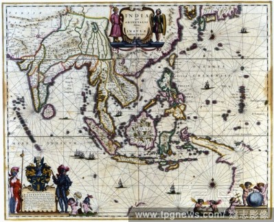
Editorial India quae orientalis dicitur et insulae adiacentes. Mapa coloreado de la India, Indochina y Filipinas. Editado en Amsterdam, a?o 1640.
- 2019-12-17
- 1

Editorial Map of the eastern part of Java, Insulae Javae pars orientalis Edinte Hadriano Relando (title on object), Map from East Java. At the top a view of Batavia from the water. There are five compass roses and topographical details have been added to the map...
- 2019-11-19
- 1
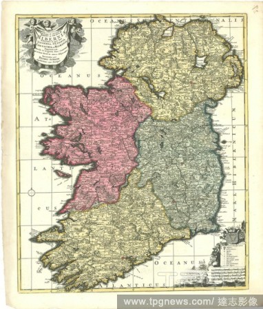
Editorial Map, Novissima et accuratissima regni en insulae Hiberniae delineatio, in qua sunt Lagenia, Ultonia, Connachia, et Momonia, provinciae, divisae in triginta duos comitatus qui et sunt divisi in omnes subjacentes baronnatus, Petrus Schenk (1693-1775), Co...
- 2019-11-18
- 1

Editorial Map, Delflandia, Schielandia et circumjacentes insulae ut Voorna, Overflackea, Goerea, Yselmonda et aliae, Nicolaes Jansz. Visscher (1649-1702), Copperplate print.
- 2019-11-18
- 1

Editorial Map, Accurata totius archipelagi et Graeciae universae tabula in qua omnes subjacentes regiones et insulae, Justus Danckertsz (1635-1701), Copperplate print.
- 2019-11-18
- 1

Editorial Map, Insulae Iavae Pars Orientalis, Adriaan Reland (1676-1718), Copperplate print.
- 2019-11-18
- 1
Editorial Map, Exactissima totius Archipelagi nec non Graeciae tabula in qua omnes subjacentes regiones et insulae distincte ostenduntur, Nicolaes Jansz. Visscher (1649-1702), Copperplate print.
- 2019-11-18
- 1
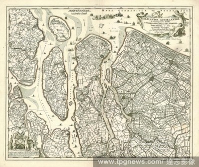
Editorial Map, Delflandia, Schielandia, et circumjacentes insulae ut Voorna, Overflackea, Goerea, Yselmonda et aliae, Nicolaes Jansz. Visscher (1649-1702), Copperplate print.
- 2019-11-18
- 1
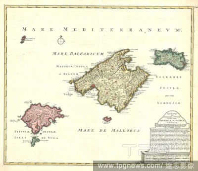
Editorial Map, Baleares seu Gymnesiae et Pityvsae insulae, dictae Maiorca, Minorca et Yvica, Reinier Ottens (1698-1750), Copperplate print.
- 2019-11-18
- 1
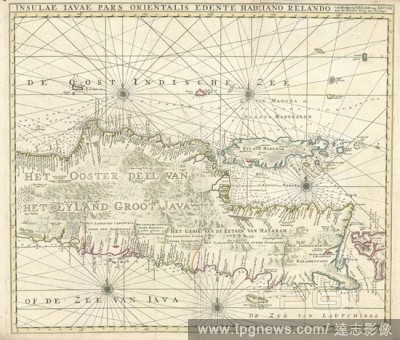
Editorial Map, Insulae Iavae Pars Orientalis, Adriaan Reland (1676-1718), Copperplate print.
- 2019-11-18
- 1
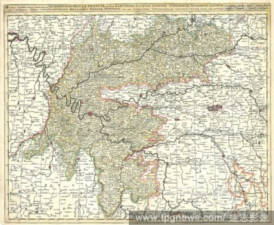
Editorial Map, Gubernatio insulae Franciae, divisa in electiones Lutetiae, Augustae Suessionum, Novioduni, Lauduni, Compendii, Bellovaci, Dresiae, Nemursii etc. cum circumjacentibus gubernationibus, Gerhard Valk (-1726), Copperplate print.
- 2019-11-18
- 1
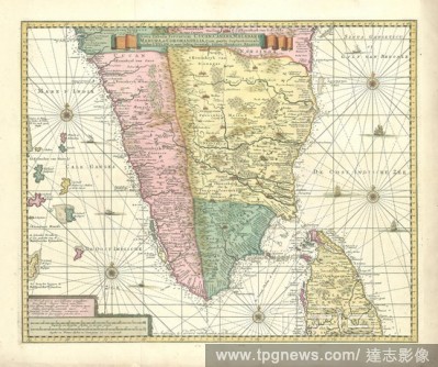
Editorial Map, Nova tabula terrarum Cucan, Canara, Malabaria, Madura, & Coromandella, cum parte septentrionali insulae Ceylon, in mari Indico Orientali, Adriaan Reland (1676-1718), Copperplate print.
- 2019-11-18
- 1

Editorial Map, Ducatus Pomeraniae tabula generalis, in qua sunt ducatus Pomeraniae, Stettinensis, Cassubiae, Vandaliae et Bardensis, pincipatus Rugiae ac insulae, comitatus Guskoviensis, et dominia Louwenburgense Wolgastense et Butoviense, Frederick de Wit (1610...
- 2019-11-18
- 1
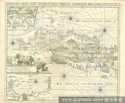
Editorial Map, Insulae Iavae Pars Occidentalis, Adriaan Reland (1676-1718), Copperplate print.
- 2019-11-18
- 1
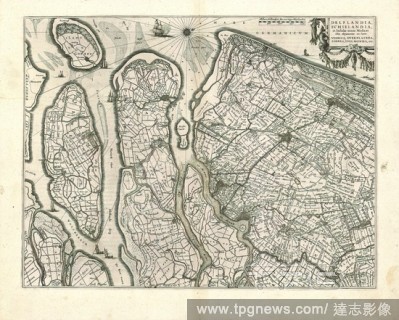
Editorial Map, Delflandia, Schielandia, et insulae trans Mosam illis objacentes ut sunt Voorna, Overflackea, Goerea, Yselmonda, etc., Willem Jansz Blaeu (1571-1638), Copperplate print.
- 2019-11-18
- 1

Editorial Map, Regni Siciliae et insulae Maltae et Gozae cum omnibus adjacentibus insulis novissima descriptio, Theodorus Danckerts (1663-1727), Copperplate print.
- 2019-11-18
- 1
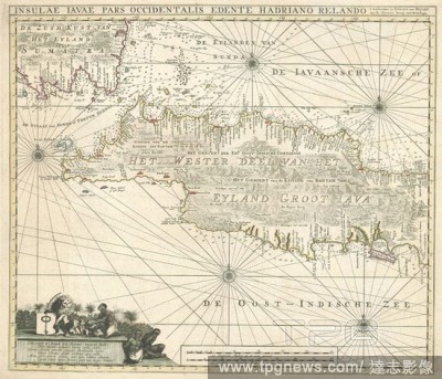
Editorial Map, Insulae Iavae Pars Occidentalis, Adriaan Reland (1676-1718), Copperplate print.
- 2019-11-18
- 1

Editorial Map, Dania regnum in quo sunt ducatus Holsatia et Slesvicum insulae Danicae et provinciae Iutia, Scania, Blekingia et Hallandia, Frederick de Wit (1610-1698), Copperplate print.
- 2019-11-18
- 1
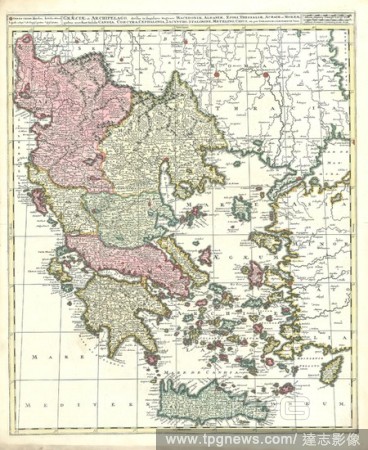
Editorial Map, Graeciae et Archipelago divisus in singulares regiones Macedoniae, Albaniae, Epiri, Thessaliae, Achaiae et Moreae, quibus accedunt insulae Candia, Corcyra, Cephalonia, Zacyntho, Stalimine, Metelino, Chius, etc, Copperplate print.
- 2019-11-18
- 1
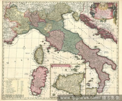
Editorial Map, Italia in suos quoscunq. status divisa, iiq. iterum in particulares ditiones distributi: huic accedunt insulae Sicilia, Sardinia, Corsica &c., quae suos ad principes nominatim referuntur, Carel Allard (1648-1709), Copperplate print.
- 2019-11-18
- 1
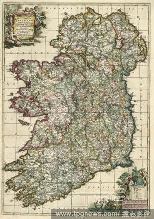
Editorial Map, Novissima ac prae caeteris aliis accuratissima Regni et Insulae Hiberniae delineatio, in qua sunt Lagenia, Ultonia, Connachia, et Momonia provinciae, divisae in triginta duos comitatus qui et sunt divisi in omnes subjacentes baronnatus, Frederick ...
- 2019-11-18
- 1
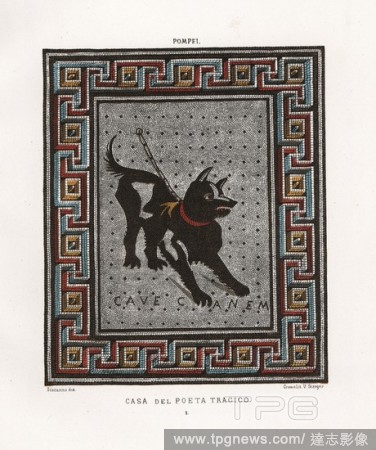
Editorial Mosaic of a guard dog on a chain from the Casa del Poeta Tragico, House of the Tragic Poet, Regio VI, Insulae 8,3,5. Chromolithograph by Victor Steeger after an illustration by Geremia Discanno from Emile Presuhn?s Les Plus Belles Peintures de Pompei (...
- 2019-02-22
- 1
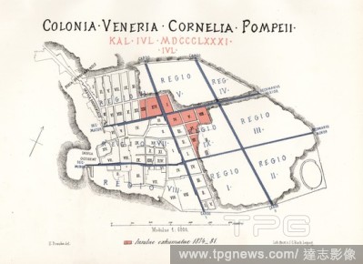
Editorial Map of the excavations of Pompeii, showing the Insulae excavated between 1874-1881 in red. Chromolithograph by J.G. Bach after an illustration by Emile Presuhn from his Les Plus Belles Peintures de Pompei (The Most Beautiful Paintings of Pompeii), Leip...
- 2019-02-22
- 1

Editorial Map of the newly excavated Insulae (buildings) in Pompeii from 1874 to 1881. Map drawn by Presuhn and lithographed by J. G. Bach from Emil Presuhn's "Pompeji. Die Neuesten Ausgrabungen von 1874-1881," Weigel, Leipzig, 1882. German archeologist Presuhn ...
- 2019-01-24
- 1
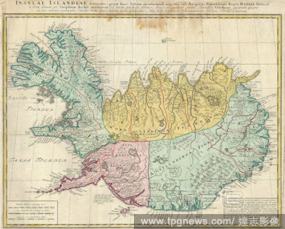
Editorial 1761, Homann Heirs Map of Iceland Insulae Islandiae.
- 2019-01-23
- 1
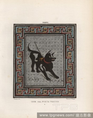
Editorial Mosaic of a guard dog on a chain from the Casa del Poeta Tragico, House of the Tragic Poet, Regio VI, Insulae 8,3,5. Illustration drawn by Discanno and lithographed by Victor Steeger from Emile Presuhn's "Choix des plus Belles et Interessantes Peinture...
- 2019-01-23
- 1
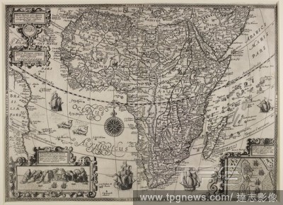
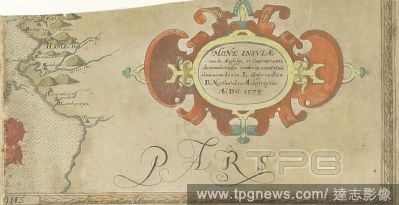
Editorial A map of Africa dated 1610. Tabula Aphricae nova sumta ex operibus L. Tercerae ... Joannes a? Duetechum junior fecit. Miliaria Germania Communia ... 150[= 47 mm.]. (Insula D. Helenae, etc, Insulae et cercis Mocambique descriptio, etc). [Deventer], [16...
- 2018-12-06
- 1

Editorial A 17th century map of Sicily. Nova et exactissima insulae Siciliae descriptio ... P. de la Houe ex. Paris, [1610?]. Source: Maps.K.Top.84.5. Language: Latin.
- 2018-12-06
- 1
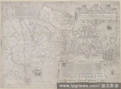
Editorial Britain. Britanniae Insulae quae nunc Angliae et Scotiae Re. Rome, 1546. Map of Britain. Image taken from Britanniae Insulae quae nunc Angliae et Scotiae Regna continet cum Hibernia adjacente nova Descriptio, etc. [With the letters G.L.A., i.e. Georgi...
- 2018-12-06
- 1

Editorial Engraving representing the Chinese Mandarins. Insulae et arcis Mocambique descriptio ad fines Melinde sitae ebano puris. auro et ambare odorato affluentis hinc magnus servorum numerus in Indiam abducitur. J.H. Linschoten in'uent. Beschrijuinge des Eijl...
- 2018-12-06
- 1
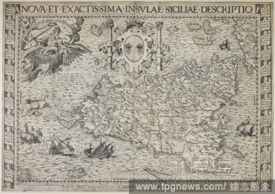
Editorial A map of the island of Sicily. Nova et exactissima insulae Siciliae descriptio ... Parisiis, [1610?]. Source: Maps K.Top.84.5. Language: Latin.
- 2018-12-06
- 1

Editorial India quae orientalis dicitur et insulae adiacentes. Mapa coloreado de la India, Indochina y Filipinas. Editado en Amsterdam, a?o 1640.
- 2018-11-21
- 1

Editorial 1761, Homann Heirs Map of Iceland Insulae Islandiae.
- 2018-08-06
- 1
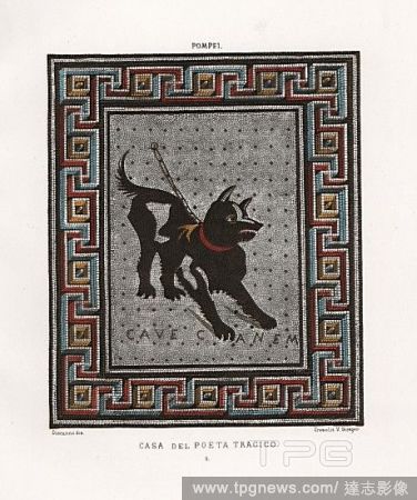
Editorial Mosaic of a guard dog on a chain from the Casa del Poeta Tragico, House of the Tragic Poet, Regio VI, Insulae 8,3,5. Chromolithograph by Victor Steeger after an illustration by Geremia Discanno from Emile Presuhn?s Les Plus Belles Peintures de Pompei (...
- 2018-08-02
- 1
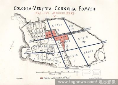
Editorial Map of the excavations of Pompeii, showing the Insulae excavated between 1874-1881 in red. Chromolithograph by J.G. Bach after an illustration by Emile Presuhn from his Les Plus Belles Peintures de Pompei (The Most Beautiful Paintings of Pompeii), Leip...
- 2018-08-02
- 1
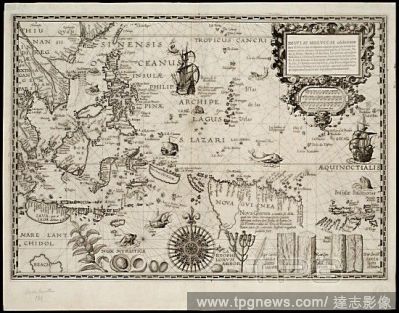
Editorial Insulae Moluccae celeberrimae sunt ob maximam aromatum copiam quam per totum terrarum orbem mittunt?.
- 2018-08-02
- 1
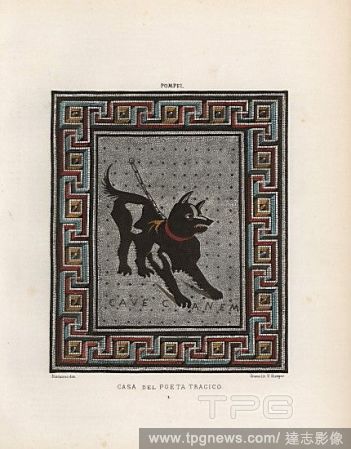
Editorial Mosaic of a guard dog on a chain from the Casa del Poeta Tragico, House of the Tragic Poet, Regio VI, Insulae 8,3,5. Illustration drawn by Discanno and lithographed by Victor Steeger from Emile Presuhn's "Choix des plus Belles et Interessantes Peinture...
- 2018-07-25
- 1
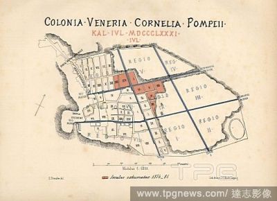
Editorial Map of the newly excavated Insulae (buildings) in Pompeii from 1874 to 1881. Map drawn by Presuhn and lithographed by J. G. Bach from Emil Presuhn's "Pompeji. Die Neuesten Ausgrabungen von 1874-1881," Weigel, Leipzig, 1882. German archeologist Presuhn ...
- 2018-07-24
- 1
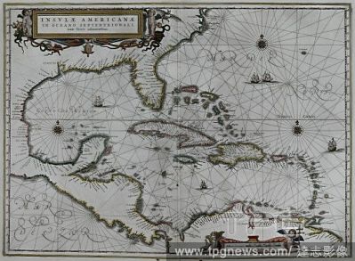
Editorial INSULAE AMERICANAE-MAPA DE AMERICA 1652.
- 2018-07-20
- 2
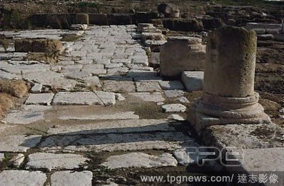
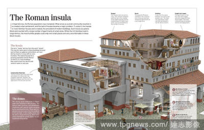
Editorial A network of streets, parallel and at right angles, cut through the " insulae" on which houses were built. In the center, two colonnaded streets formed a cross. The roadbeds were paved with limestone while the colonnaded walkways had mosaic f...
- 2018-06-20
- 8
 Loading