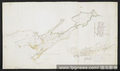
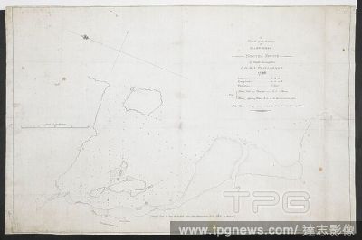
EditorialA plan of the harbour of Mahwinnee, Nootka Sound, by Capt. Broughton of MS Providence 1796'. . R.U.S.I. MAPS. Vol. LXXIII (1-13). 18th century. Ink on paper. 380 x 560mm. 1:3200. 'Scale of 200 fathoms' (= 4.5 inches). Map oriented with East-North-Eas...
EditorialPlan of the fort and attack of Niagara . . . by Qr Mr Jones of the 46th'; circa 1760. . R.U.S.I. MAPS. Vol. LXXIII (1-13). 18th century. Circa 1760 . 1:7200. 'Scale of 100 fathoms to an inch'. 395 x 890mm. Source: Add. 57708 f.10 Amherst no. A 50. R...
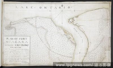
EditorialPlan of Fort Niagara with its environs', by George Demler; 1760. . R.U.S.I. MAPS. Vol. LXXIII (1-13). 'Plan of Fort Niagara with its environs', by George Demler. Surveyed and laid down 1760 by Geo. Demler ... April 1760. 1:7200. 'Scale of 500 fathoms'...
EditorialColoured plan of Cornwallis Island with ink detail of the town of Halifax with lettered explanation including North & South suburbs, fathoms marked. . SIXTY-SEVEN Charts and maps illustrating the voyages and surveys of Capt. James Cook, R.N., and othe...
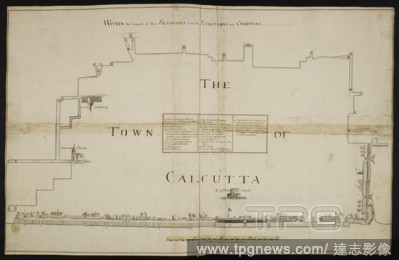
EditorialA plan or bird's-eye view of that part of Calcutta within the compass of the Palisades, wherein live the Europeans and Christians, with a table shewing the occupants of the buildings; drawn in 1742, by Foresti and Ollifres, on a scale of 20 fathoms to ...
EditorialPlan of Fort Niagara with its environs', by George Demler; 1760. . R.U.S.I. MAPS. Vol. LXXIII (1-13). 'Plan of Fort Niagara with its environs', by George Demler. Surveyed and laid down 1760 by Geo. Demler ... April 1760. 1:7200. 'Scale of 500 fathoms'...
EditorialColoured plan of Cornwallis Island with ink detail of the town of Halifax with lettered explanation including North & South suburbs, fathoms marked. . SIXTY-SEVEN Charts and maps illustrating the voyages and surveys of Capt. James Cook, R.N., and othe...
EditorialA plan of the harbour of Mahwinnee, Nootka Sound, by Capt. Broughton of MS Providence 1796'. . R.U.S.I. MAPS. Vol. LXXIII (1-13). 18th century. Ink on paper. 380 x 560mm. 1:3200. 'Scale of 200 fathoms' (= 4.5 inches). Map oriented with East-North-Eas...
EditorialPlan of the fort and attack of Niagara . . . by Qr Mr Jones of the 46th'; circa 1760. . R.U.S.I. MAPS. Vol. LXXIII (1-13). 18th century. Circa 1760 . 1:7200. 'Scale of 100 fathoms to an inch'. 395 x 890mm. Source: Add. 57708 f.10 Amherst no. A 50. R...
EditorialPlan of the fort and attack of Niagara . . . by Qr Mr Jones of the 46th'; circa 1760. . R.U.S.I. MAPS. Vol. LXXIII (1-13). 18th century. Circa 1760 . 1:7200. 'Scale of 100 fathoms to an inch'. 395 x 890mm. Source: Add. 57708 f.10 Amherst no. A 50. R...
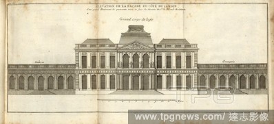
EditorialElevation of the facade on the side of the garden of a large building forty fathoms opposite the design of Sr. Blond Architect, Elevation of a large building, tab. 83, after p. 200, Augustin-Charles d'Aviler, Vignola, Michelangelo, Leonhard Christoph S...
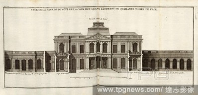
EditorialView of the facade of the courtyard side of a large building forty fathoms in front, Elevation of the main house, the bath rooms, and the gallery in the wing after Le Blond, Tab. 82, to p. 200, Sturm, Leonhard Christian, 1725, Giacomo Barozzi da Vignol...
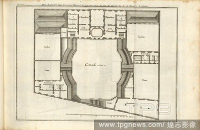
EditorialPlan of the first floor of a large building forty fathoms from front of the design of Sr. Blond Architect, Plan of the 1st floor of a large building, Tab. 81, to p. 200, Augustin-Charles d'Aviler, Vignola, Michelangelo, Leonhard Christoph Sturm, Hertel...
EditorialA plan of the harbour of Mahwinnee, Nootka Sound, by Capt. Broughton of MS Providence 1796'. . R.U.S.I. MAPS. Vol. LXXIII (1-13). 18th century. Ink on paper. 380 x 560mm. 1:3200. 'Scale of 200 fathoms' (= 4.5 inches). Map oriented with East-North-Eas...
EditorialA plan or bird's-eye view of that part of Calcutta within the compass of the Palisades, wherein live the Europeans and Christians, with a table shewing the occupants of the buildings; drawn in 1742, by Foresti and Ollifres, on a scale of 20 fathoms to ...
EditorialPlan of the fort and attack of Niagara . . . by Qr Mr Jones of the 46th'; circa 1760. . R.U.S.I. MAPS. Vol. LXXIII (1-13). 18th century. Circa 1760 . 1:7200. 'Scale of 100 fathoms to an inch'. 395 x 890mm. Source: Add. 57708 f.10 Amherst no. A 50. R...
EditorialPlan of Fort Niagara with its environs', by George Demler; 1760. . R.U.S.I. MAPS. Vol. LXXIII (1-13). 'Plan of Fort Niagara with its environs', by George Demler. Surveyed and laid down 1760 by Geo. Demler ... April 1760. 1:7200. 'Scale of 500 fathoms'...
EditorialColoured plan of Cornwallis Island with ink detail of the town of Halifax with lettered explanation including North & South suburbs, fathoms marked. . SIXTY-SEVEN Charts and maps illustrating the voyages and surveys of Capt. James Cook, R.N., and othe...
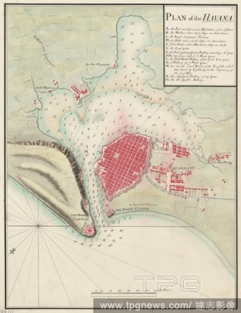
EditorialPlan of the Havana. A plan of the Havana, with the soundings of the ha. c.1800. Plan of the Havana. Image taken from A plan of the Havana, with the soundings of the harbour; drawn about 1800, on a scale of 240 fathoms to an inch. Originally published...


 Loading