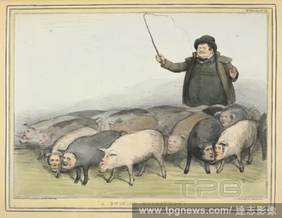
Editorial"A swinish multitude'. A number of politicians portrayed a pigs, with human faces : 1. Lord Palmerston. 2. Lord Glenelg. 3. Lord John Russell. 4. Lord Melbourne. 5. Lord Duncannon. 6. Lord Lansdowne. 7. Lord Mulgrave. 8. Lord Morpeth, Mr Ellice, and Mr...
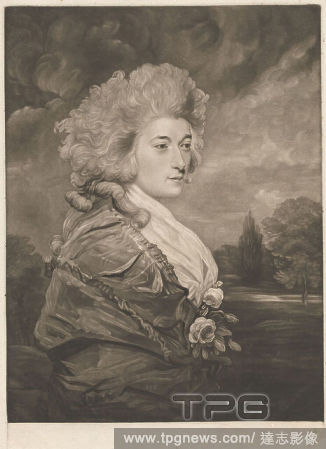
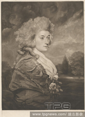
EditorialViscountess Duncannon, Print made by Joseph Grozer, ca. 17551798, British, after Sir Joshua Reynolds RA, 17231792, British, ca. 1785, Mezzotint and etching on moderately thick, moderately textured, cream laid paper, Sheet: 16 5/16 x 11 11/16 inches (41...
EditorialHenrietta Frances, Viscountess Duncannon (1761-1811) Sister to her Grace the Duchess of Devonshire, Joseph Grozer, ca. 17551798, British, after Sir Joshua Reynolds RA, 17231792, British, 1786, Mezzotint, Sheet: 13 7/8 x 10 3/4in. (35.2 x 27.3cm).
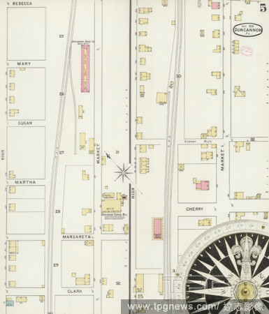
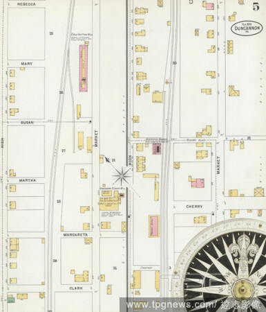
EditorialImage 5 of Sanborn Fire Insurance Map from Duncannon, Perry County, Pennsylvania. Aug 1894. 5 Sheet(s), America, street map with a Nineteenth Century compass.
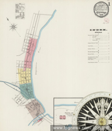
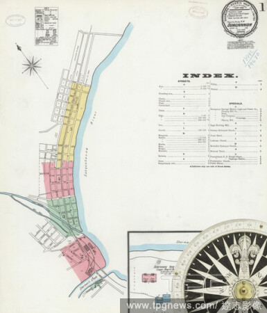
EditorialImage 1 of Sanborn Fire Insurance Map from Duncannon, Perry County, Pennsylvania. Aug 1894. 5 Sheet(s), America, street map with a Nineteenth Century compass.
EditorialImage 1 of Sanborn Fire Insurance Map from Duncannon, Perry County, Pennsylvania. Jan 1888. 3 Sheet(s), America, street map with a Nineteenth Century compass.
EditorialImage 3 of Sanborn Fire Insurance Map from Duncannon, Perry County, Pennsylvania. Jan 1888. 3 Sheet(s), America, street map with a Nineteenth Century compass.
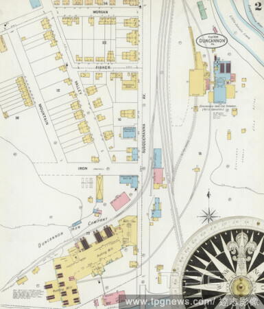
EditorialImage 2 of Sanborn Fire Insurance Map from Duncannon, Perry County, Pennsylvania. Feb 1899. 5 Sheet(s), America, street map with a Nineteenth Century compass.
EditorialImage 5 of Sanborn Fire Insurance Map from Duncannon, Perry County, Pennsylvania. Feb 1899. 5 Sheet(s), America, street map with a Nineteenth Century compass.
EditorialImage 2 of Sanborn Fire Insurance Map from Duncannon, Perry County, Pennsylvania. Aug 1894. 5 Sheet(s), America, street map with a Nineteenth Century compass.
EditorialImage 3 of Sanborn Fire Insurance Map from Duncannon, Perry County, Pennsylvania. Aug 1894. 5 Sheet(s), America, street map with a Nineteenth Century compass.
EditorialImage 2 of Sanborn Fire Insurance Map from Duncannon, Perry County, Pennsylvania. Jan 1888. 3 Sheet(s), America, street map with a Nineteenth Century compass.
EditorialImage 4 of Sanborn Fire Insurance Map from Duncannon, Perry County, Pennsylvania. Aug 1894. 5 Sheet(s), America, street map with a Nineteenth Century compass.
EditorialImage 3 of Sanborn Fire Insurance Map from Duncannon, Perry County, Pennsylvania. Feb 1899. 5 Sheet(s), America, street map with a Nineteenth Century compass.
EditorialImage 1 of Sanborn Fire Insurance Map from Duncannon, Perry County, Pennsylvania. Feb 1899. 5 Sheet(s), America, street map with a Nineteenth Century compass.
EditorialImage 4 of Sanborn Fire Insurance Map from Duncannon, Perry County, Pennsylvania. Feb 1899. 5 Sheet(s), America, street map with a Nineteenth Century compass.
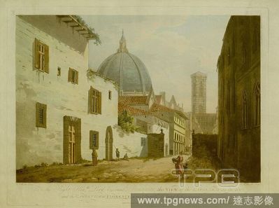
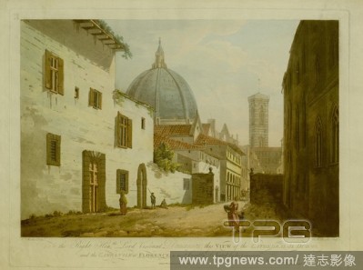
EditorialA view of a street in Florence, with a beggar, a soldier and a mother with a child walking in the foreground. The dome of the cathedral and the campanile seen above rooftops in the background. VIEW of the CATHEDRAL IL DUOMO, and the CAMPANILE at FLOREN...
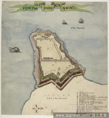
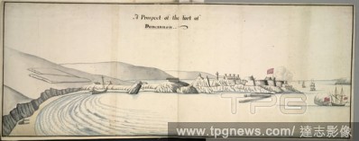
EditorialShips on the water; the Fort of Duncannon stretching across the middle ground; rocks and the shore on the left; hills in the distance. A Prospect of the Fort of Duncannon. c. 1690. Source: Maps K.Top.55.42.a. Language: English.
EditorialA view of a street in Florence, with a beggar, a soldier and a mother with a child walking in the foreground. The dome of the cathedral and the campanile seen above rooftops in the background. VIEW of the CATHEDRAL IL DUOMO, and the CAMPANILE at FLOREN...
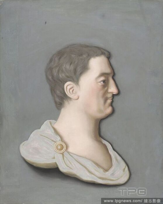
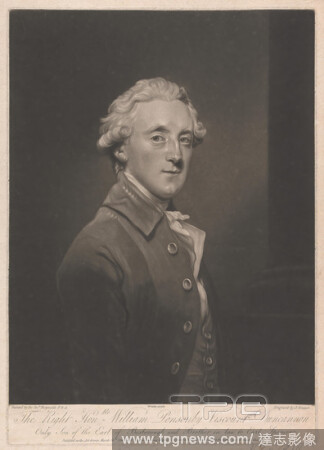
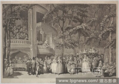
EditorialWillam Ponsonby, Viscount Duncannon and Later 2nd Earl of Bessborough William Ponsonby (1704-93), Viscount Duncannon and later 2nd Earl of Bessborough, Portrait of William Ponsonby (1704-93), Viscount Duncannon, later 2nd Earl of Bessborough, friend an...
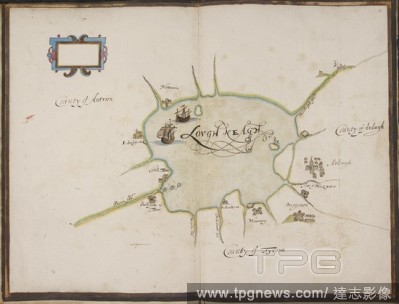
EditorialDrawing of Lough Neagh, Ireland . STATE of the Fortes of Ireland as they weare in the yeare 1624;" fourteen coloured plans of the river of Waterford and the forts of Duncannon, Waterford, Haleboline [Cork Haven], Cork, Kinsale, Culmore, Galway, Bannaho...
Editorial"A swinish multitude'. A number of politicians portrayed a pigs, with human faces : 1. Lord Palmerston. 2. Lord Glenelg. 3. Lord John Russell. 4. Lord Melbourne. 5. Lord Duncannon. 6. Lord Lansdowne. 7. Lord Mulgrave. 8. Lord Morpeth, Mr Ellice, and Mr...
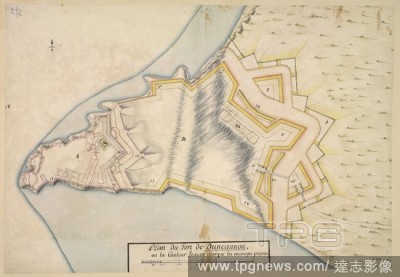
EditorialA plan of the fort of Duncannon. A pencilled plan of the fort of Duncannon, with a project for large additional outworks; drawn on a scale of 50 feet to an inch. ca. 1690-1700. Source: Maps K.Top.55.41. Language: French.
EditorialA view of a street in Florence, with a beggar, a soldier and a mother with a child walking in the foreground. The dome of the cathedral and the campanile seen above rooftops in the background. VIEW of the CATHEDRAL IL DUOMO, and the CAMPANILE at FLOREN...
EditorialDuncannon Fort, County Wexford, Leinster, Ireland. This map shows Duncannon fort in County Wexford. It dates from around 1611 and is therefore contemporary with the English plantation scheme. This scheme aimed to establish an English colony in Ulster ...
EditorialShips on the water; the Fort of Duncannon stretching across the middle ground; rocks and the shore on the left; hills in the distance. A Prospect of the Fort of Duncannon. c. 1690. Source: Maps K.Top.55.42.a. Language: English.
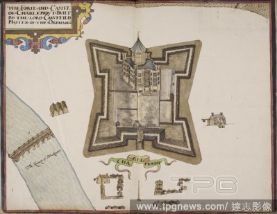
EditorialIllustration of Charlemont castle. An album of the forts and castles of Ireland. . STATE of the Fortes of Ireland as they weare in the yeare 1624. Image from "State of the Fortes of Ireland as they weare in the yeare 1624;" fourteen coloured plans of t...
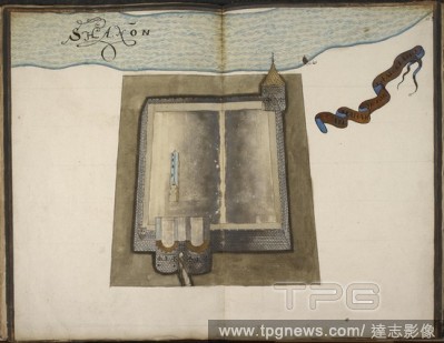
EditorialIllustration of Shannon castle. A book of plans of Irish castles. . STATE of the Fortes of Ireland as they weare in the yeare 1624. From "State of the Fortes of Ireland as they weare in the yeare 1624;" fourteen coloured plans of the river of Waterford...
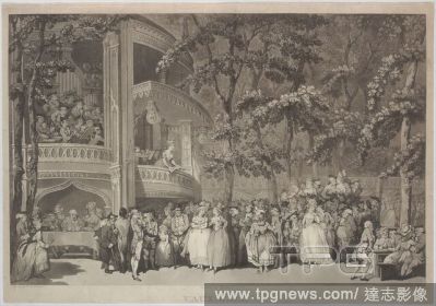
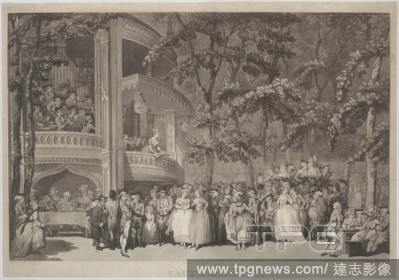
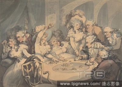
EditorialA Gaming Table at Devonshire House, 1791, Pen and ink and watercolor, sheet: 12 1/8 x 17 1/8 in. (30.8 x 43.5 cm), Drawings, Thomas Rowlandson (British, London 1757?1827 London), Rowlandson underscored gambling?s grip on British aristocrats at the end ...


 Loading