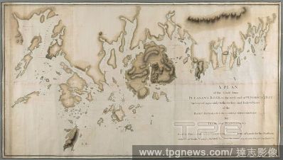
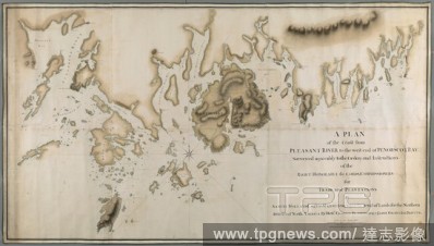
EditorialA plan of the coast from Pleasant River to the west end of Penobscott Bay. A PLAN of the Coast from PLEASANT RIVER to the west end of PENOBSCOT BAY / Surveyed agreeably to the Orders and Instructions of the RIGHT HONORABLE the LORDS COMMISSIONERS for T...
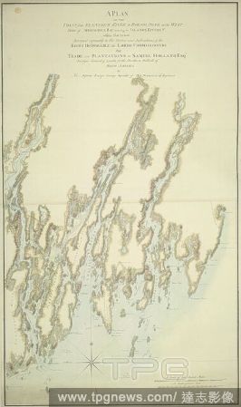
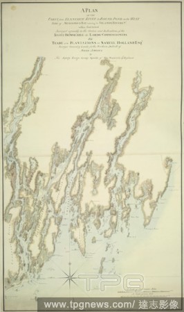
EditorialA plan of the coast from Kennebeck River to Round Pond. A PLAN OF THE COAST from KENNEBECK RIVER to ROUND POND on the WEST SIDE of MUSCONGUS BAY, including the ISLANDS, RIVERS, &c. within that Extent / Surveyed agreeably to the Orders and Instructions ...
EditorialHow to Ride Genteel and Agreeably Downhill. Drawing. Watercolor with pen and red-brown ink, wash, over graphite; verso: graphite tracing on medium, slightly textured, beige, wove paper mounted on wove paper. Height: 106 mm (4.17 in); Width: 110 mm (4.3...
EditorialA plan of the coast from Pleasant River to the west end of Penobscott Bay. A PLAN of the Coast from PLEASANT RIVER to the west end of PENOBSCOT BAY / Surveyed agreeably to the Orders and Instructions of the RIGHT HONORABLE the LORDS COMMISSIONERS for T...
EditorialSt. Paul's Cathedral. Section of St. Paul's Cathedral, decorated agreeab. 1755. A section of St. Paul's Cathedral. Image taken from Section of St. Paul's Cathedral, decorated agreeably to the original intention of Sir Christopher Wren, by Wale and Gwy...
EditorialA plan of the coast from Kennebeck River to Round Pond. A PLAN OF THE COAST from KENNEBECK RIVER to ROUND POND on the WEST SIDE of MUSCONGUS BAY, including the ISLANDS, RIVERS, &c. within that Extent / Surveyed agreeably to the Orders and Instructions ...
EditorialHow to Ride Genteel and Agreeably Downhill. Drawing. Watercolor with pen and red-brown ink, wash, over graphite; verso: graphite tracing on medium, slightly textured, beige, wove paper mounted on wove paper. Height: 106 mm (4.17 in); Width: 110 mm (4.3...


 Loading