
filter
-
Brand
- By Category
- Direction
- Date Range
336Events
Pictures
Events

Editorial Cost of living survey
- 2024-10-14
- 1

Editorial Cost of living survey
- 2024-10-13
- 1

Editorial Children's physical activity research
- 2024-09-19
- 1

Editorial Incontinence study
- 2024-08-01
- 1

Editorial Incontinence study
- 2024-07-31
- 1

Editorial German Economy Faces Challenges as Consumer Activity Persists, Berlin, Berlin, Germany - 25 Jul 2024
- 2024-07-26
- 22

Editorial Germany: German Economy Faces Challenges as Consumer Activity Persists
- 2024-07-26
- 22

Editorial British Berry Growers
- 2024-07-23
- 6

Editorial Santander UK survey
- 2024-07-21
- 1

Editorial Santander UK survey
- 2024-07-20
- 1

Editorial NHS waits on children
- 2024-07-15
- 1

Editorial NHS waits on children
- 2024-07-14
- 1

Editorial Spending boost for sports fans this summer
- 2024-07-03
- 1

Editorial Zurich Municipal survey
- 2024-06-28
- 1

Editorial Zurich Municipal survey
- 2024-06-27
- 1

Editorial YouGov survey
- 2024-06-27
- 1

Editorial YouGov survey
- 2024-06-27
- 1

Editorial Scots with aphasia
- 2024-05-31
- 2

Editorial Online misinformation
- 2024-05-30
- 1

Editorial Online misinformation
- 2024-05-29
- 1

Editorial Cyclone Remal Damage, Tehatta, India - 27 May 2024
- 2024-05-28
- 14

Editorial Elderly Voters Cast Ballot From Home For Lok Sabha Elections, India - 13 May 2024
- 2024-05-14
- 10

Editorial State of Ageing report
- 2024-05-08
- 1

Editorial Wallingford Boat House pub hit by flooding closed 'until further notice', Wallingford, Oxfordshire, UK - 05 May 2024
- 2024-05-05
- 9

Editorial Citizen science projects
- 2024-03-04
- 1

Editorial Citizen science projects
- 2024-03-03
- 1

Editorial Social care report
- 2024-01-15
- 1

Editorial 90% of companies say they'll return to the office by the end of 2024, Reading, Berkshire, UK - 15 Jan 2024
- 2024-01-15
- 3

Editorial Luke Shaw File Photo
- 2023-12-24
- 1

Editorial Charity Shelter's poll
- 2023-12-22
- 2

Editorial British Pregnancy Advisory Service survey
- 2023-12-17
- 1

Editorial British Pregnancy Advisory Service survey
- 2023-12-07
- 1

Editorial EXCLUSIVE: Frankie Bridge recreates classic 90s moments including Ginger Spice's Union Jack frock and Liz Hurley's 'That dress'
- 2023-11-30
- 41

Editorial Barton House Tower block evacuation, Bristol, UK - 17 Nov 2023
- 2023-11-18
- 14
Editorial Barton House Tower block evacuation, Bristol, UK - 17 Nov 2023
- 2023-11-17
- 1

Editorial Beyond Ofsted inquiry report
- 2023-11-01
- 1

Editorial Beyond Ofsted inquiry report
- 2023-10-31
- 1

Editorial Lewis Ferguson File Photo
- 2023-10-18
- 1

Editorial Holiday survey
- 2023-10-16
- 1

Editorial Holiday survey
- 2023-10-15
- 1

Editorial Physical education survey
- 2023-10-11
- 1

Editorial Physical education survey
- 2023-10-10
- 1

Editorial Lina, 15 Disappeared For a Week - 30 Sep 2023
- 2023-10-02
- 144

Editorial EXCLUSIVE: Quarter of Gen Zs feel urge to check their phones after just 15 minutes of driving
- 2023-09-18
- 5

Editorial Pension survey
- 2023-09-13
- 1

Editorial Pension survey
- 2023-09-13
- 1

Editorial Spending survey
- 2023-09-09
- 2

Editorial US President Biden Views Wildfire Aftermath On Maui
- 2023-08-24
- 1

Editorial US President Biden Views Wildfire Aftermath On Maui
- 2023-08-24
- 3

Editorial Shelter survey
- 2023-08-21
- 1

Editorial Shopping survey
- 2023-08-09
- 1

Editorial Diversity & Inclusivity in the workplace Survey
- 2023-08-09
- 1

Editorial Loan fee fraud
- 2023-08-09
- 2

Editorial Diversity & Inclusivity in the workplace Survey
- 2023-08-08
- 1

Editorial Shopping survey
- 2023-08-08
- 1

Editorial Forget Bugs, Rebel Wilson Crushes Them With Zevo?s Hilarious ?Bugxiety? Campaign
- 2023-08-01
- 1

Editorial Portraits of Mermaid Joanne for World Conservation Nature Day
- 2023-07-27
- 17

Editorial Open University research
- 2023-06-28
- 1

Editorial Ipsos UK survey
- 2023-06-28
- 2

Editorial Ipsos UK survey
- 2023-06-23
- 1

Editorial Ipsos UK survey
- 2023-06-18
- 3

Editorial Ipsos UK survey
- 2023-06-16
- 2

Editorial Ipsos UK survey
- 2023-06-14
- 1

Editorial Ipsos UK survey
- 2023-06-13
- 1

Editorial Ipsos UK survey
- 2023-05-28
- 11

Editorial Ipsos UK survey
- 2023-05-17
- 1

Editorial Ipsos UK survey
- 2023-04-10
- 1

Editorial Ipsos UK survey
- 2023-04-09
- 2

Editorial Ipsos UK survey
- 2023-04-07
- 3

Editorial Ipsos UK survey
- 2023-03-29
- 1

Editorial Ipsos UK survey
- 2023-03-22
- 1

Editorial Ipsos UK survey
- 2023-03-21
- 1

Editorial Thu Ahn Nguyen at her home in Gaithersburg, Md., March 7, 2023. (Jared Soares/The New York Times)
- 2023-03-14
- 3

Editorial An uprooted tree damaged a home in Monterey, Calif., on Friday, March 10, 2023. (Daniel Dreifuss/The New York Times)
- 2023-03-12
- 2

Editorial An uprooted tree damaged a home in Monterey, Calif., on Friday, March 10, 2023. (Daniel Dreifuss/The New York Times)
- 2023-03-03
- 1

Editorial An uprooted tree damaged a home in Monterey, Calif., on Friday, March 10, 2023. (Daniel Dreifuss/The New York Times)
- 2023-03-02
- 1

Editorial An uprooted tree damaged a home in Monterey, Calif., on Friday, March 10, 2023. (Daniel Dreifuss/The New York Times)
- 2023-02-27
- 1

Editorial An uprooted tree damaged a home in Monterey, Calif., on Friday, March 10, 2023. (Daniel Dreifuss/The New York Times)
- 2023-02-26
- 1

Editorial Workers at a factory in Scranton, Pa., on Jan. 30, 2023. Democratic strategists surveyed voters in major industrial states, including Pennsylvania. (Natalie Keyssar/The New York Times)
- 2023-02-23
- 1

Editorial Student's rental costs
- 2023-02-08
- 2

Editorial Alcohol-Pandemic, Halifax, Canada - 01 Aug 2018
- 2023-02-02
- 1

Editorial Pornography report
- 2023-01-31
- 1

Editorial Pornography report
- 2023-01-30
- 1

Editorial Greenland Ice Sheet Warming Faster Than Previously Thought
- 2023-01-20
- 11

Editorial Manufacturing report
- 2023-01-09
- 1

Editorial Manufacturing report
- 2023-01-08
- 1

Editorial Brahman cattle are surveyed from a helicopter at Waterloo Station in the Northern Territory of Australia on Aug. 23, 2022. (George Steinmetz/The New York Times)
- 2022-12-31
- 1

Editorial Xmas gifts
- 2022-12-29
- 1

Editorial Xmas gifts
- 2022-12-28
- 1
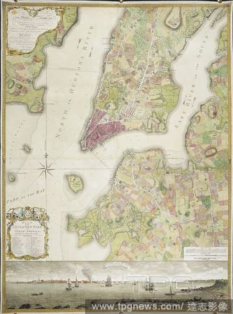
Editorial Plan of the City of New York, in North America: surveyed in the years 1766 & 1767. Plan of the City of New York, in North America: surveyed in the years 1766 & 1767. To His Excellency Sir Henry Moore, Bart ... This Plan of the City of New York and its ...
- 2022-12-24
- 1
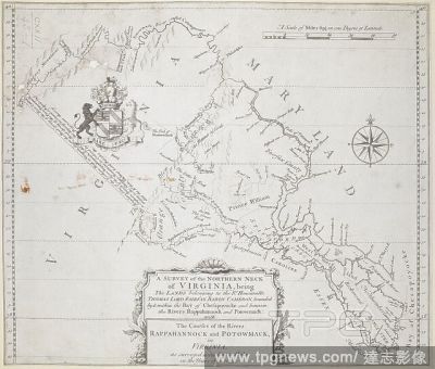
Editorial A survey of the northern neck of Virginia. A SURVEY of the NORTHERN NECK of VIRGINIA, being The LANDS belonging to the R.t Honourable THOMAS LORD FAIRFAX BARON CAMERON, bounded by & within the Bay of Chesapoyocke and between the Rivers Rappahannock and...
- 2022-12-24
- 1

Editorial A map of Alton, Madison County, Illinois. City of Alton. Surveyed and published by Hart and Mapother, Civil Engineers ... Scale, 5 chains to an inch. New York, 1854. Source: Maps 72790.(9.). Language: English.
- 2022-12-24
- 1
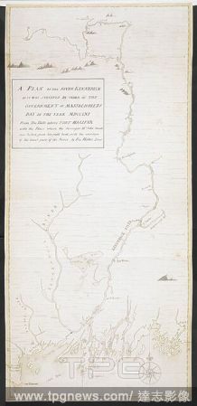
Editorial A plan of the River Kennebeck as it was surveyed by order of the Government of Massachusets Bay in the year MDCCLXI from the falls above Halifax unto the place where the surveyor John Small was killed, from his field book, with the addition of lower pa...
- 2022-12-24
- 1

Editorial A map of Pennsylvania, 1687. . "A map of the province of Pennsilvania, containing the three countyes of Chester, Philadelphia, and Bucks, as far as yet surveyed and laid out, &c., with the names of the owners, by Thomas Holme, surveyor-general," 1...
- 2022-12-24
- 1
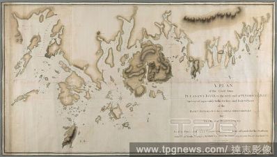
Editorial A plan of the coast from Pleasant River to the west end of Penobscott Bay. A PLAN of the Coast from PLEASANT RIVER to the west end of PENOBSCOT BAY / Surveyed agreeably to the Orders and Instructions of the RIGHT HONORABLE the LORDS COMMISSIONERS for T...
- 2022-12-24
- 1
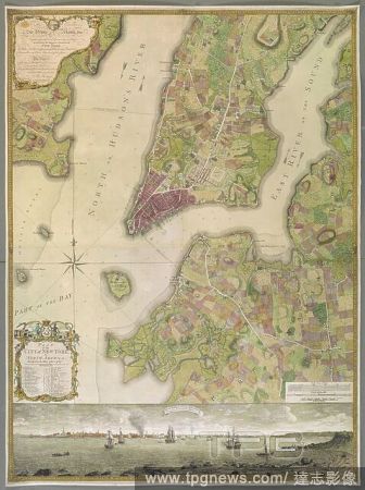
Editorial An 18th century plan of the city of New York. PLAN of the CITY of NEW YORK, in North America : Surveyed in the Years 1766 & 1767 / B. Ratzer, Lieut.t in His Majestys 60th or Royal American Reg.t. [London] : [Thomas Kitchin], [about 1770.]. 1 map on 3 s...
- 2022-12-24
- 1

Editorial A plan of Sandy Hook, 28 miles from New York, surveyed April 15th, 1757: showing the best channel for sailing to New York, with its banks and depths of water. PLAN OF SANDY HOOK 28. Miles from New York. [New York?] : [producer not identified], 1757. So...
- 2022-12-24
- 1
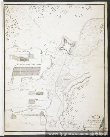
Editorial Plan of Fort Stanwix at the Onnida station', surveyed by 'Fran. Pfister Ens. 1760.' . R.U.S.I. MAPS. Vol. LXXVI (1-13). 57711 (1-4). Places in states North-East of New York. 18th century. 1764. 1:1800. 'Scale of 150 feet to one inch'. Scale bar of 30...
- 2022-12-24
- 1

Editorial New York and Staten Islands. A colored map of New York and Staten Islands, and. 1781. Map of New York and Staten Islands, and part of Long Island. Image taken from A colored map of New York and Staten Islands, and part of Long Island; surveyed by orde...
- 2022-12-24
- 2
 Loading