
filter
-
Brand
- By Category
- Direction
- Date Range
192Events
Pictures
Events

Editorial
- 2023-11-14
- 1
Editorial
- 2023-11-01
- 1
Editorial
- 2023-11-01
- 1

Editorial
- 2023-11-01
- 1

Editorial
- 2023-06-16
- 1

Editorial
- 2023-06-16
- 1

Editorial
- 2023-03-30
- 1

Editorial
- 2023-03-17
- 1

Editorial Stephen Van Rensselaer III. Dated: 1793/1795. Dimensions: overall: 91.7 x 71.3 cm (36 1/8 x 28 1/16 in.) framed: 113 x 92.7 x 6.7 cm (44 1/2 x 36 1/2 x 2 5/8 in.). Medium: oil on canvas.
- 2022-12-25
- 1

Editorial Stephen Van Rensselaer III. Dated: 1793/1795. Dimensions: overall: 91.7 x 71.3 cm (36 1/8 x 28 1/16 in.) framed: 113 x 92.7 x 6.7 cm (44 1/2 x 36 1/2 x 2 5/8 in.). Medium: oil on canvas.
- 2022-07-22
- 1

Editorial A bridge over Kinderhook Creek, along the Albany-Hudson Electric Trail in Kinderhook, N.Y. on Oct. 13, 2021. (Johnny Milano/The New York Times)
- 2021-11-10
- 1

Editorial A bridge over Kinderhook Creek, along the Albany-Hudson Electric Trail in Kinderhook, N.Y. on Oct. 13, 2021. (Johnny Milano/The New York Times)
- 2021-11-07
- 1

Editorial NY: Severe Flooding Follows Rensselaer County State Of Emergency, United States - 15 Jul 2021
- 2021-07-17
- 27

Editorial Stephen Van Rensselaer III. Dated: 1793/1795. Dimensions: overall: 91.7 x 71.3 cm (36 1/8 x 28 1/16 in.) framed: 113 x 92.7 x 6.7 cm (44 1/2 x 36 1/2 x 2 5/8 in.). Medium: oil on canvas.
- 2021-04-07
- 1
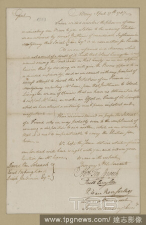
Editorial Ten Broeck, Abraham, Jacob Cuyler, P. Van Rensselaer, Leonard Gansevoort and John Lansing, Jr. Albany. To David Van Schaack, Evert Vosburgh and Dirck Gardinier, text, Documents, 1787.
- 2021-04-07
- 1

Editorial Jeremias van Rensselaer, still image, Prints, 1850 - 1900.
- 2021-02-22
- 2

Editorial Van Rensselaer, Solomon. Albany. Adjt. General's Office. To Major General Peter Van Orden, text, Documents, 1817.
- 2021-02-22
- 2
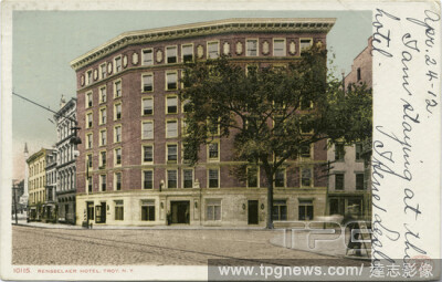
Editorial Rensselaer Hotel, Troy, N. Y., still image, Postcards, 1898 - 1931.
- 2021-02-22
- 2

Editorial Design for a Bookplate: Colonial Dames of America, Mrs. John King Van Rensselaer, American, 18481925, Steel engraving on white paper, Bookplate design engraved in black featuring a fan of the cabriolet type. A banderole or ribbon with the text 'Colonia...
- 2021-02-22
- 1

Editorial Maker: Nicholas Van Rensselaer, w. c. 1760 - 1770, Pair of knee?buckles, Silver, steel or iron, 1 3/16 ? 1 5/8 in. (3 ? 4.13 cm), Made in New York, New Yorkor made in Albany, New York, American, 18th?century, Jewelry.
- 2021-02-21
- 1

Editorial Maker: Nicholas Van Rensselaer, w. c. 1760 - 1770, Stock?buckle, ca.?176070, Silver, 1 3/8 ? 2 in. (3.5 ? 5.08 cm), Made in New York, New Yorkor made in Albany, New York, American, 18th?century, Jewelry.
- 2021-02-21
- 1

Editorial Stephen Van Rensselaer III. Dated: 1793/1795. Dimensions: overall: 91.7 x 71.3 cm (36 1/8 x 28 1/16 in.) framed: 113 x 92.7 x 6.7 cm (44 1/2 x 36 1/2 x 2 5/8 in.). Medium: oil on canvas.
- 2021-02-20
- 1

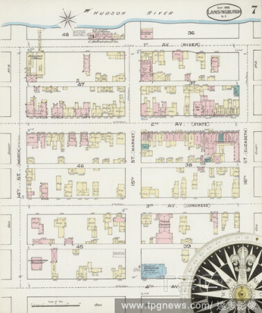
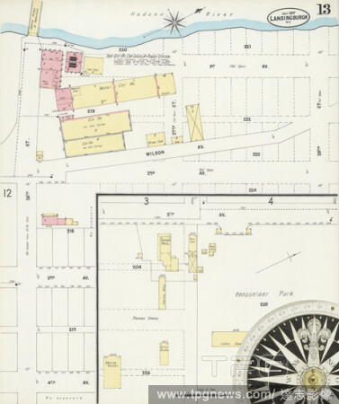
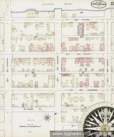
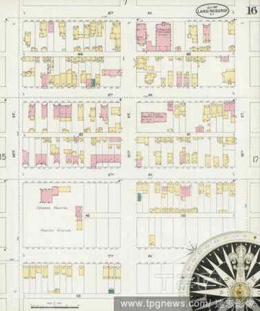
Editorial Image 18 of Sanborn Fire Insurance Map from Lansingburg, Rensselaer County, New York. Jul 1897. 23 Sheet(s), America, street map with a Nineteenth Century compass.
- 2021-02-20
- 2

Editorial Image 10 of Sanborn Fire Insurance Map from Troy, Rensselaer County, New York. 1885-1904 1885 Vol. 2. 61 Sheet(s). Includes West Troy, Green Island. Double-paged plates numbered 27-55. Bound, America, street map with a Nineteenth Century compass.
- 2021-02-20
- 1

Editorial Image 29 of Sanborn Fire Insurance Map from Troy, Rensselaer County, New York. 1885-1904 1885 Vol. 1. 55 Sheet(s). Double-paged plates numbered 1-26. Bound, America, street map with a Nineteenth Century compass.
- 2021-02-20
- 1
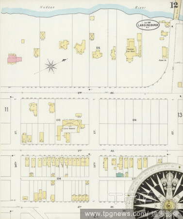
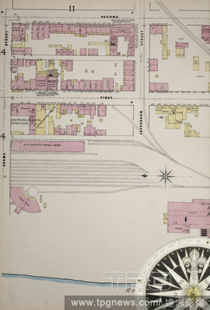
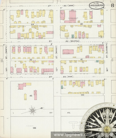
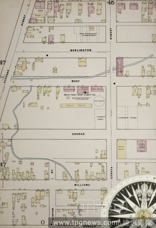
Editorial Image 12 of Sanborn Fire Insurance Map from Lansingburg, Rensselaer County, New York. Jul 1897. 23 Sheet(s), America, street map with a Nineteenth Century compass.
- 2021-02-20
- 2
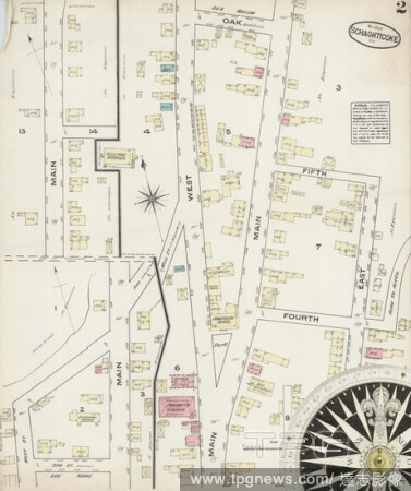
Editorial Image 2 of Sanborn Fire Insurance Map from Schaghticoke, Rensselaer County, New York. May 1884. 2 Sheet(s), America, street map with a Nineteenth Century compass.
- 2021-02-20
- 2

Editorial Image 33 of Sanborn Fire Insurance Map from Troy, Rensselaer County, New York. 1885-1904 1885 Vol. 1. 55 Sheet(s). Double-paged plates numbered 1-26. Bound, America, street map with a Nineteenth Century compass.
- 2021-02-20
- 1
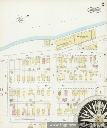
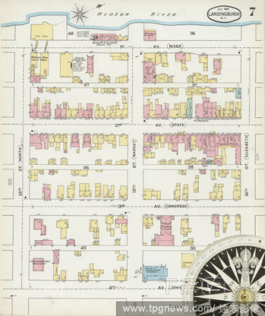
Editorial Image 2 of Sanborn Fire Insurance Map from Lansingburg, Rensselaer County, New York. Jul 1897. 23 Sheet(s), America, street map with a Nineteenth Century compass.
- 2021-02-20
- 1
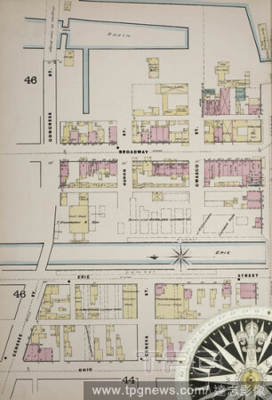
Editorial Image 25 of Sanborn Fire Insurance Map from Troy, Rensselaer County, New York. 1885-1904 1885 Vol. 1. 55 Sheet(s). Double-paged plates numbered 1-26. Bound, America, street map with a Nineteenth Century compass.
- 2021-02-20
- 1

Editorial Image 2 of Sanborn Fire Insurance Map from Schaghticoke, Rensselaer County, New York. May 1897. 4 Sheet(s), America, street map with a Nineteenth Century compass.
- 2021-02-20
- 2

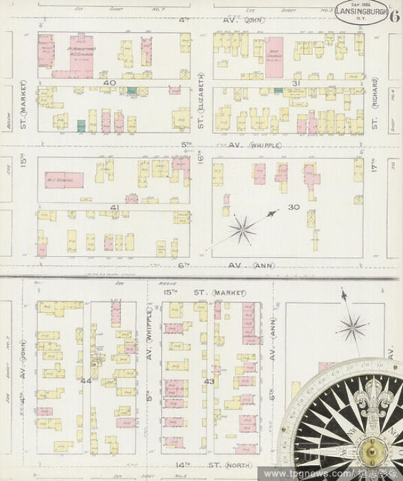
Editorial Image 9 of Sanborn Fire Insurance Map from Lansingburg, Rensselaer County, New York. Sep 1886. 14 Sheet(s), America, street map with a Nineteenth Century compass.
- 2021-02-20
- 2

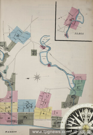
Editorial Image 3 of Sanborn Fire Insurance Map from Troy, Rensselaer County, New York. 1885-1904 1885 Vol. 1. 55 Sheet(s). Double-paged plates numbered 1-26. Bound, America, street map with a Nineteenth Century compass.
- 2021-02-20
- 1
Editorial Image 21 of Sanborn Fire Insurance Map from Troy, Rensselaer County, New York. 1885-1904 1885 Vol. 1. 55 Sheet(s). Double-paged plates numbered 1-26. Bound, America, street map with a Nineteenth Century compass.
- 2021-02-20
- 1

Editorial Image 6 of Sanborn Fire Insurance Map from Lansingburg, Rensselaer County, New York. Jul 1892. 16 Sheet(s), America, street map with a Nineteenth Century compass.
- 2021-02-20
- 1

Editorial Image 4 of Sanborn Fire Insurance Map from Lansingburg, Rensselaer County, New York. Jul 1897. 23 Sheet(s), America, street map with a Nineteenth Century compass.
- 2021-02-20
- 2

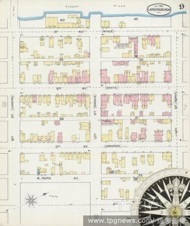
Editorial Image 10 of Sanborn Fire Insurance Map from Lansingburg, Rensselaer County, New York. Jul 1897. 23 Sheet(s), America, street map with a Nineteenth Century compass.
- 2021-02-20
- 1
Editorial Image 7 of Sanborn Fire Insurance Map from Lansingburg, Rensselaer County, New York. Jul 1892. 16 Sheet(s), America, street map with a Nineteenth Century compass.
- 2021-02-20
- 1
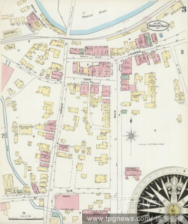
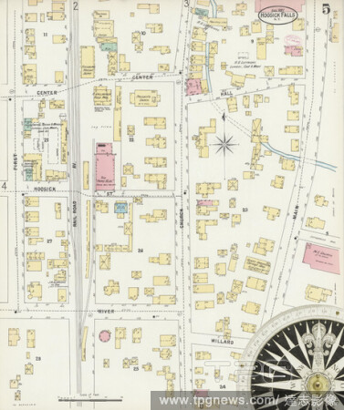
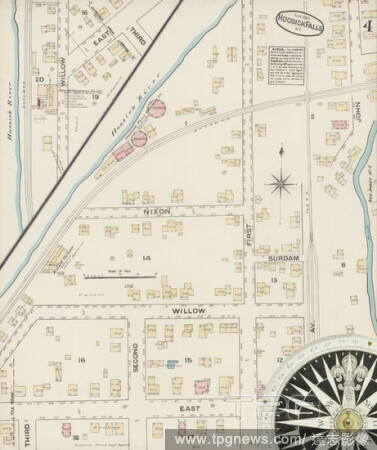
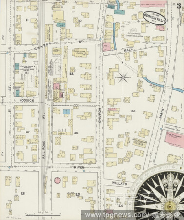
Editorial Image 3 of Sanborn Fire Insurance Map from Hoosick Falls, Rensselaer County, New York. Aug 1897. 9 Sheet(s), America, street map with a Nineteenth Century compass.
- 2021-02-20
- 3
Editorial Image 14 of Sanborn Fire Insurance Map from Lansingburg, Rensselaer County, New York. Jul 1892. 16 Sheet(s), America, street map with a Nineteenth Century compass.
- 2021-02-20
- 1
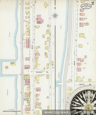
Editorial Image 2 of Sanborn Fire Insurance Map from Castleton On Hudson, Rensselaer County, New York. Mar 1898. 2 Sheet(s), America, street map with a Nineteenth Century compass.
- 2021-02-20
- 1
Editorial Image 7 of Sanborn Fire Insurance Map from Lansingburg, Rensselaer County, New York. Sep 1886. 14 Sheet(s), America, street map with a Nineteenth Century compass.
- 2021-02-20
- 1
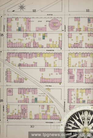
Editorial Image 12 of Sanborn Fire Insurance Map from Troy, Rensselaer County, New York. 1885-1904 1885 Vol. 2. 61 Sheet(s). Includes West Troy, Green Island. Double-paged plates numbered 27-55. Bound, America, street map with a Nineteenth Century compass.
- 2021-02-20
- 1
Editorial Image 23 of Sanborn Fire Insurance Map from Troy, Rensselaer County, New York. 1885-1904 1885 Vol. 1. 55 Sheet(s). Double-paged plates numbered 1-26. Bound, America, street map with a Nineteenth Century compass.
- 2021-02-20
- 2

Editorial Image 35 of Sanborn Fire Insurance Map from Troy, Rensselaer County, New York. 1885-1904 1885 Vol. 2. 61 Sheet(s). Includes West Troy, Green Island. Double-paged plates numbered 27-55. Bound, America, street map with a Nineteenth Century compass.
- 2021-02-20
- 1
Editorial Image 5 of Sanborn Fire Insurance Map from Hoosick Falls, Rensselaer County, New York. Aug 1897. 9 Sheet(s), America, street map with a Nineteenth Century compass.
- 2021-02-20
- 2

Editorial Image 8 of Sanborn Fire Insurance Map from Lansingburg, Rensselaer County, New York. Jul 1897. 23 Sheet(s), America, street map with a Nineteenth Century compass.
- 2021-02-20
- 1

Editorial Image 17 of Sanborn Fire Insurance Map from Troy, Rensselaer County, New York. 1885-1904 1885 Vol. 1. 55 Sheet(s). Double-paged plates numbered 1-26. Bound, America, street map with a Nineteenth Century compass.
- 2021-02-20
- 2

Editorial Image 27 of Sanborn Fire Insurance Map from Troy, Rensselaer County, New York. 1885-1904 1885 Vol. 2. 61 Sheet(s). Includes West Troy, Green Island. Double-paged plates numbered 27-55. Bound, America, street map with a Nineteenth Century compass.
- 2021-02-20
- 1
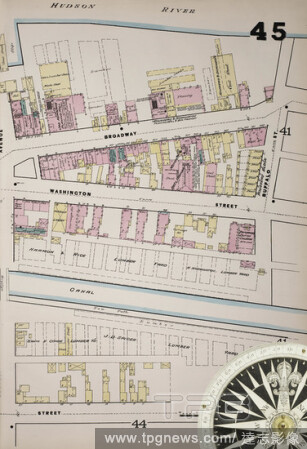
Editorial Image 40 of Sanborn Fire Insurance Map from Troy, Rensselaer County, New York. 1885-1904 1885 Vol. 2. 61 Sheet(s). Includes West Troy, Green Island. Double-paged plates numbered 27-55. Bound, America, street map with a Nineteenth Century compass.
- 2021-02-20
- 1
Editorial Image 1 of Sanborn Fire Insurance Map from Schaghticoke, Rensselaer County, New York. May 1897. 4 Sheet(s), America, street map with a Nineteenth Century compass.
- 2021-02-20
- 1

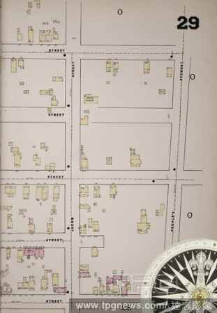
Editorial Image 29 of Sanborn Fire Insurance Map from Troy, Rensselaer County, New York. 1885-1904 1885 Vol. 2. 61 Sheet(s). Includes West Troy, Green Island. Double-paged plates numbered 27-55. Bound, America, street map with a Nineteenth Century compass.
- 2021-02-20
- 3

Editorial Image 22 of Sanborn Fire Insurance Map from Troy, Rensselaer County, New York. 1885-1904 1885 Vol. 1. 55 Sheet(s). Double-paged plates numbered 1-26. Bound, America, street map with a Nineteenth Century compass.
- 2021-02-20
- 1

Editorial Image 17 of Sanborn Fire Insurance Map from Troy, Rensselaer County, New York. 1885-1904 1885 Vol. 2. 61 Sheet(s). Includes West Troy, Green Island. Double-paged plates numbered 27-55. Bound, America, street map with a Nineteenth Century compass.
- 2021-02-20
- 2
Editorial Image 24 of Sanborn Fire Insurance Map from Troy, Rensselaer County, New York. 1885-1904 1885 Vol. 2. 61 Sheet(s). Includes West Troy, Green Island. Double-paged plates numbered 27-55. Bound, America, street map with a Nineteenth Century compass.
- 2021-02-20
- 2

Editorial Image 26 of Sanborn Fire Insurance Map from Troy, Rensselaer County, New York. 1885-1904 1885 Vol. 2. 61 Sheet(s). Includes West Troy, Green Island. Double-paged plates numbered 27-55. Bound, America, street map with a Nineteenth Century compass.
- 2021-02-20
- 2

Editorial Image 13 of Sanborn Fire Insurance Map from Troy, Rensselaer County, New York. 1885-1904 1885 Vol. 2. 61 Sheet(s). Includes West Troy, Green Island. Double-paged plates numbered 27-55. Bound, America, street map with a Nineteenth Century compass.
- 2021-02-20
- 1
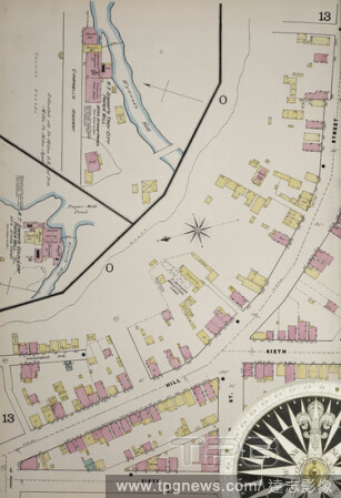
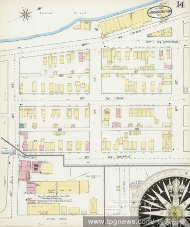
Editorial Image 13 of Sanborn Fire Insurance Map from Lansingburg, Rensselaer County, New York. Jul 1897. 23 Sheet(s), America, street map with a Nineteenth Century compass.
- 2021-02-20
- 1

Editorial Image 40 of Sanborn Fire Insurance Map from Troy, Rensselaer County, New York. 1885-1904 1885 Vol. 1. 55 Sheet(s). Double-paged plates numbered 1-26. Bound, America, street map with a Nineteenth Century compass.
- 2021-02-20
- 2
Editorial Image 9 of Sanborn Fire Insurance Map from Lansingburg, Rensselaer County, New York. Jul 1892. 16 Sheet(s), America, street map with a Nineteenth Century compass.
- 2021-02-20
- 1
Editorial Image 32 of Sanborn Fire Insurance Map from Troy, Rensselaer County, New York. 1885-1904 1885 Vol. 2. 61 Sheet(s). Includes West Troy, Green Island. Double-paged plates numbered 27-55. Bound, America, street map with a Nineteenth Century compass.
- 2021-02-20
- 2

Editorial Image 3 of Sanborn Fire Insurance Map from Valley Falls, Rensselaer County, New York. Aug 1897. 3 Sheet(s), America, street map with a Nineteenth Century compass.
- 2021-02-19
- 2
Editorial Image 8 of Sanborn Fire Insurance Map from Lansingburg, Rensselaer County, New York. Jul 1892. 16 Sheet(s), America, street map with a Nineteenth Century compass.
- 2021-02-19
- 2

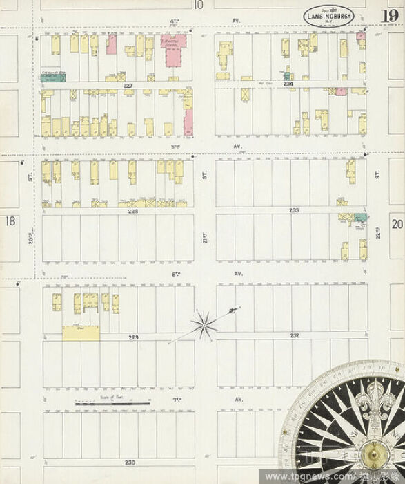
Editorial Image 19 of Sanborn Fire Insurance Map from Lansingburg, Rensselaer County, New York. Jul 1897. 23 Sheet(s), America, street map with a Nineteenth Century compass.
- 2021-02-19
- 4

Editorial Image 11 of Sanborn Fire Insurance Map from Lansingburg, Rensselaer County, New York. Sep 1886. 14 Sheet(s), America, street map with a Nineteenth Century compass.
- 2021-02-19
- 2

Editorial Image 32 of Sanborn Fire Insurance Map from Troy, Rensselaer County, New York. 1885-1904 1885 Vol. 1. 55 Sheet(s). Double-paged plates numbered 1-26. Bound, America, street map with a Nineteenth Century compass.
- 2021-02-19
- 2

Editorial Image 20 of Sanborn Fire Insurance Map from Troy, Rensselaer County, New York. 1885-1904 1885 Vol. 1. 55 Sheet(s). Double-paged plates numbered 1-26. Bound, America, street map with a Nineteenth Century compass.
- 2021-02-19
- 4
Editorial Image 4 of Sanborn Fire Insurance Map from Hoosick Falls, Rensselaer County, New York. Jun 1884. 4 Sheet(s), America, street map with a Nineteenth Century compass.
- 2021-02-19
- 2

Editorial Image 3 of Sanborn Fire Insurance Map from Troy, Rensselaer County, New York. 1885-1904 1885 Vol. 2. 61 Sheet(s). Includes West Troy, Green Island. Double-paged plates numbered 27-55. Bound, America, street map with a Nineteenth Century compass.
- 2021-02-19
- 2
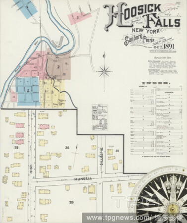
Editorial Image 1 of Sanborn Fire Insurance Map from Hoosick Falls, Rensselaer County, New York. Oct 1891. 6 Sheet(s), America, street map with a Nineteenth Century compass.
- 2021-02-19
- 4
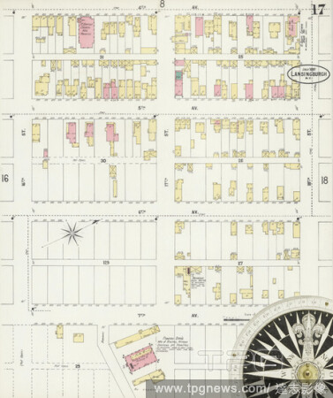
Editorial Image 17 of Sanborn Fire Insurance Map from Lansingburg, Rensselaer County, New York. Jul 1897. 23 Sheet(s), America, street map with a Nineteenth Century compass.
- 2021-02-19
- 2

Editorial Image 10 of Sanborn Fire Insurance Map from Troy, Rensselaer County, New York. 1885-1904 1885 Vol. 1. 55 Sheet(s). Double-paged plates numbered 1-26. Bound, America, street map with a Nineteenth Century compass.
- 2021-02-19
- 8
Editorial Image 16 of Sanborn Fire Insurance Map from Troy, Rensselaer County, New York. 1885-1904 1885 Vol. 1. 55 Sheet(s). Double-paged plates numbered 1-26. Bound, America, street map with a Nineteenth Century compass.
- 2021-02-19
- 8

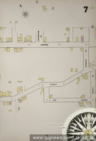
Editorial Image 6 of Sanborn Fire Insurance Map from Hoosick Falls, Rensselaer County, New York. Aug 1897. 9 Sheet(s), America, street map with a Nineteenth Century compass.
- 2021-02-19
- 4

Editorial Image 11 of Sanborn Fire Insurance Map from Lansingburg, Rensselaer County, New York. Jul 1892. 16 Sheet(s), America, street map with a Nineteenth Century compass.
- 2021-02-19
- 2
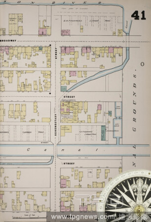
Editorial Image 39 of Sanborn Fire Insurance Map from Troy, Rensselaer County, New York. 1885-1904 1885 Vol. 2. 61 Sheet(s). Includes West Troy, Green Island. Double-paged plates numbered 27-55. Bound, America, street map with a Nineteenth Century compass.
- 2021-02-19
- 2

Editorial Image 2 of Sanborn Fire Insurance Map from Valley Falls, Rensselaer County, New York. Aug 1897. 3 Sheet(s), America, street map with a Nineteenth Century compass.
- 2021-02-19
- 2
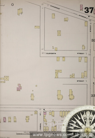
Editorial Image 37 of Sanborn Fire Insurance Map from Troy, Rensselaer County, New York. 1885-1904 1885 Vol. 2. 61 Sheet(s). Includes West Troy, Green Island. Double-paged plates numbered 27-55. Bound, America, street map with a Nineteenth Century compass.
- 2021-02-19
- 4

Editorial Image 18 of Sanborn Fire Insurance Map from Troy, Rensselaer County, New York. 1885-1904 1885 Vol. 2. 61 Sheet(s). Includes West Troy, Green Island. Double-paged plates numbered 27-55. Bound, America, street map with a Nineteenth Century compass.
- 2021-02-19
- 2
Editorial Image 5 of Sanborn Fire Insurance Map from Lansingburg, Rensselaer County, New York. Jul 1892. 16 Sheet(s), America, street map with a Nineteenth Century compass.
- 2021-02-19
- 2

Editorial Image 33 of Sanborn Fire Insurance Map from Troy, Rensselaer County, New York. 1885-1904 1885 Vol. 2. 61 Sheet(s). Includes West Troy, Green Island. Double-paged plates numbered 27-55. Bound, America, street map with a Nineteenth Century compass.
- 2021-02-19
- 2
Editorial Image 8 of Sanborn Fire Insurance Map from Lansingburg, Rensselaer County, New York. Sep 1886. 14 Sheet(s), America, street map with a Nineteenth Century compass.
- 2021-02-19
- 4

Editorial Image 2 of Sanborn Fire Insurance Map from Troy, Rensselaer County, New York. 1885-1904 1885 Vol. 2. 61 Sheet(s). Includes West Troy, Green Island. Double-paged plates numbered 27-55. Bound, America, street map with a Nineteenth Century compass.
- 2021-02-19
- 4

Editorial Image 16 of Sanborn Fire Insurance Map from Lansingburg, Rensselaer County, New York. Jul 1892. 16 Sheet(s), America, street map with a Nineteenth Century compass.
- 2021-02-19
- 2
Editorial Image 3 of Sanborn Fire Insurance Map from Hoosick Falls, Rensselaer County, New York. Oct 1891. 6 Sheet(s), America, street map with a Nineteenth Century compass.
- 2021-02-19
- 2
Editorial Image 2 of Sanborn Fire Insurance Map from Troy, Rensselaer County, New York. 1885-1904 1885 Vol. 1. 55 Sheet(s). Double-paged plates numbered 1-26. Bound, America, street map with a Nineteenth Century compass.
- 2021-02-19
- 2

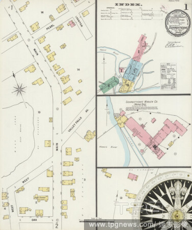
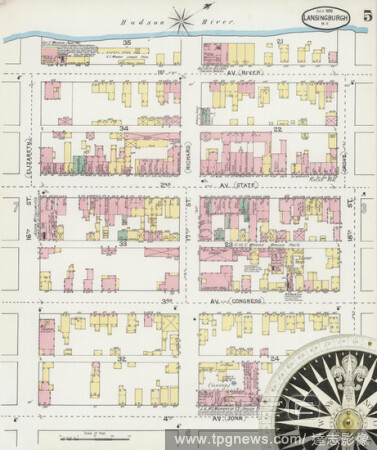
Editorial Image 1 of Sanborn Fire Insurance Map from Lansingburg, Rensselaer County, New York. Jul 1897. 23 Sheet(s), America, street map with a Nineteenth Century compass.
- 2021-02-19
- 2
Editorial Image 16 of Sanborn Fire Insurance Map from Lansingburg, Rensselaer County, New York. Jul 1897. 23 Sheet(s), America, street map with a Nineteenth Century compass.
- 2021-02-19
- 2

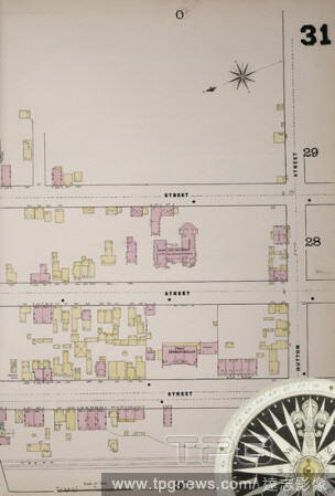
Editorial Image 31 of Sanborn Fire Insurance Map from Troy, Rensselaer County, New York. 1885-1904 1885 Vol. 1. 55 Sheet(s). Double-paged plates numbered 1-26. Bound, America, street map with a Nineteenth Century compass.
- 2021-02-19
- 2

Editorial Image 36 of Sanborn Fire Insurance Map from Troy, Rensselaer County, New York. 1885-1904 1885 Vol. 2. 61 Sheet(s). Includes West Troy, Green Island. Double-paged plates numbered 27-55. Bound, America, street map with a Nineteenth Century compass.
- 2021-02-19
- 4

Editorial Image 28 of Sanborn Fire Insurance Map from Troy, Rensselaer County, New York. 1885-1904 1885 Vol. 1. 55 Sheet(s). Double-paged plates numbered 1-26. Bound, America, street map with a Nineteenth Century compass.
- 2021-02-19
- 4

Editorial Image 28 of Sanborn Fire Insurance Map from Troy, Rensselaer County, New York. 1885-1904 1885 Vol. 2. 61 Sheet(s). Includes West Troy, Green Island. Double-paged plates numbered 27-55. Bound, America, street map with a Nineteenth Century compass.
- 2021-02-19
- 4
Editorial Image 8 of Sanborn Fire Insurance Map from Troy, Rensselaer County, New York. 1885-1904 1885 Vol. 2. 61 Sheet(s). Includes West Troy, Green Island. Double-paged plates numbered 27-55. Bound, America, street map with a Nineteenth Century compass.
- 2021-02-19
- 2

Editorial Image 4 of Sanborn Fire Insurance Map from Troy, Rensselaer County, New York. 1885-1904 1885 Vol. 1. 55 Sheet(s). Double-paged plates numbered 1-26. Bound, America, street map with a Nineteenth Century compass.
- 2021-02-19
- 2
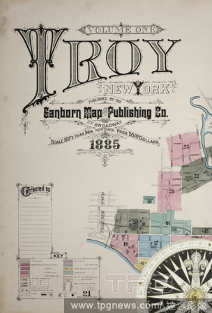
Editorial Image 1 of Sanborn Fire Insurance Map from Troy, Rensselaer County, New York. 1885-1904 1885 Vol. 1. 55 Sheet(s). Double-paged plates numbered 1-26. Bound, America, street map with a Nineteenth Century compass.
- 2021-02-19
- 2
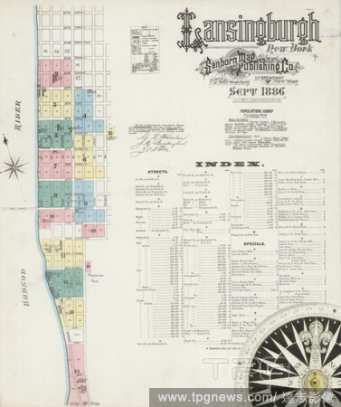
Editorial Image 1 of Sanborn Fire Insurance Map from Lansingburg, Rensselaer County, New York. Sep 1886. 14 Sheet(s), America, street map with a Nineteenth Century compass.
- 2021-02-19
- 2

Editorial Image 11 of Sanborn Fire Insurance Map from Troy, Rensselaer County, New York. 1885-1904 1885 Vol. 1. 55 Sheet(s). Double-paged plates numbered 1-26. Bound, America, street map with a Nineteenth Century compass.
- 2021-02-19
- 2

Editorial Image 15 of Sanborn Fire Insurance Map from Lansingburg, Rensselaer County, New York. Jul 1897. 23 Sheet(s), America, street map with a Nineteenth Century compass.
- 2021-02-19
- 2

Editorial Image 34 of Sanborn Fire Insurance Map from Troy, Rensselaer County, New York. 1885-1904 1885 Vol. 1. 55 Sheet(s). Double-paged plates numbered 1-26. Bound, America, street map with a Nineteenth Century compass.
- 2021-02-19
- 4
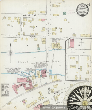
Editorial Image 1 of Sanborn Fire Insurance Map from Valley Falls, Rensselaer County, New York. Aug 1891. 2 Sheet(s), America, street map with a Nineteenth Century compass.
- 2021-02-19
- 2
 Loading