
filter
-
Brand
- By Category
- Direction
- Date Range
157Events
Pictures
Events
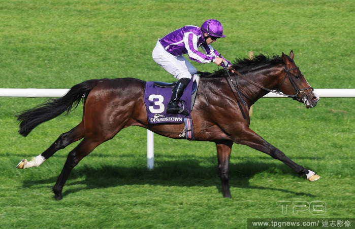
Editorial Leopardstown Races - Sunday 12th May
- 2024-05-13
- 2

Editorial Leopardstown Races - Sunday 12th May
- 2023-11-01
- 1
Editorial Leopardstown Races - Sunday 12th May
- 2023-11-01
- 1
Editorial Leopardstown Races - Sunday 12th May
- 2023-11-01
- 2
Editorial Leopardstown Races - Sunday 12th May
- 2023-11-01
- 1
Editorial Leopardstown Races - Sunday 12th May
- 2023-11-01
- 2

Editorial Leopardstown Races - Sunday 12th May
- 2023-06-15
- 1

Editorial Leopardstown Races - Sunday 12th May
- 2023-06-15
- 1
Editorial Leopardstown Races - Sunday 12th May
- 2023-06-14
- 1
Editorial Leopardstown Races - Sunday 12th May
- 2023-06-14
- 1

Editorial Leopardstown Races - Sunday 12th May
- 2023-06-14
- 1
Editorial Leopardstown Races - Sunday 12th May
- 2023-06-14
- 1

Editorial Leopardstown Races - Sunday 12th May
- 2023-06-07
- 1
Editorial Leopardstown Races - Sunday 12th May
- 2023-06-07
- 1
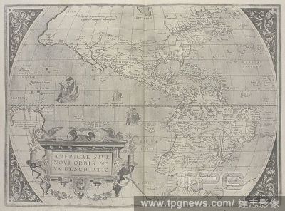
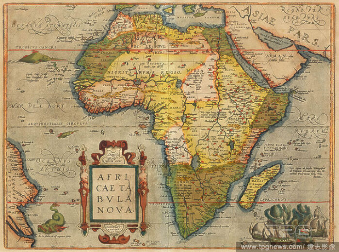
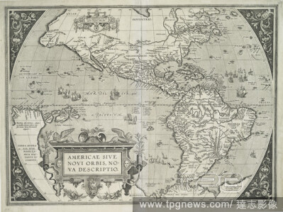
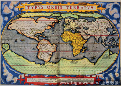
Editorial Americae sive novi orbis, no va descriptio. 16th century Map of America, by Ortelius. Theatrvm Orbis Terrarvm. Anvers : De l'Imprimerie de Christofle Plantin, pour Abraham Ortel, autheur mesme de ce liure, 1587. Source: Maps.C.2.d.2 before page 6.
- 2022-12-24
- 1
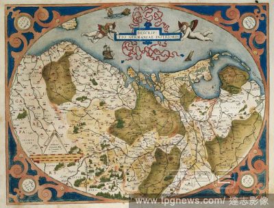
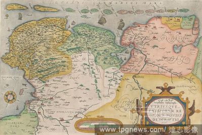
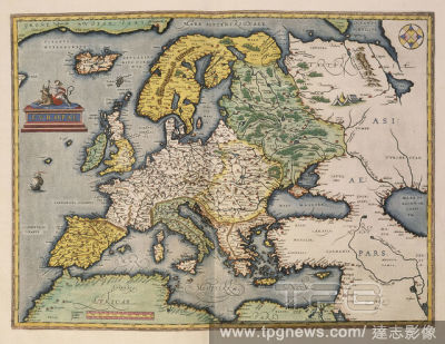
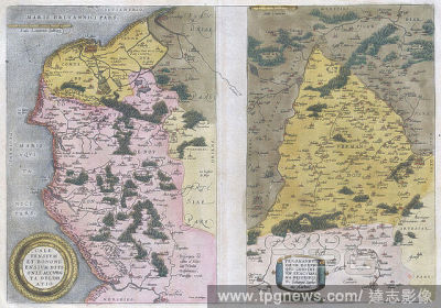
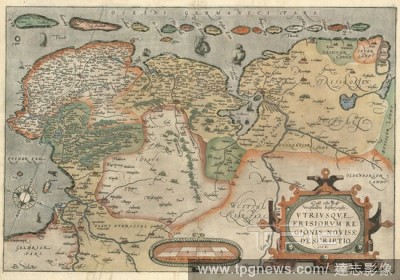
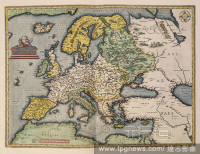
Editorial Map of Germany and current Netherlands. Theatrum Orbis Terrarum by Abraham Ortelius (1527-1598). First Edition. Antwerp, 1574. Library of Catalonia. Barcelona. Spain.
- 2022-12-24
- 2

Editorial MAPA DE EUROPA Y NORTE DE AFRICA - SIGLO XVI - FOTOGRAFIA EN BLANCO Y NEGRO - A?OS 60.
- 2022-12-23
- 4

Editorial MAPA SUR EUROPA Y NORTE AFRICA-ORB.TERRARUM-1570-.
- 2022-12-23
- 1

Editorial MAPA DE HOLANDA - SIGLO XVI.
- 2022-12-23
- 4
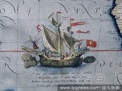
Editorial DETALLE DE LA NAO VICTORIA - MAPA DEL OCEANO PACIFICO - 1589.
- 2022-07-21
- 1
Editorial MAPA DE EUROPA Y NORTE DE AFRICA - SIGLO XVI.
- 2022-07-21
- 1

Editorial AMERICA SIVE NOVI ORBIS - 1587 - THEATRUM ORBIS TERRARUM.
- 2022-07-21
- 3

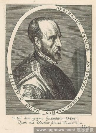
Editorial Abraham Ortelius, frontispiece to his 'Theatrum Orbis Terrarum' - 1579 - engraving. ABRAHAM ORTELIUS (1527-1598). ORTELIO ABRAHAM.
- 2022-07-21
- 1
Editorial World map. 1579. Madrid, Geographic department of the Army.
- 2022-07-21
- 1

Editorial MAPA DE LA BAHIA DE CADIZ GUIPUZCOA Y MADRID 1584.
- 2022-07-21
- 6
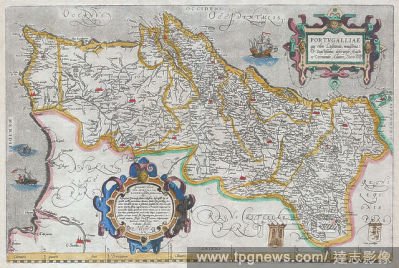
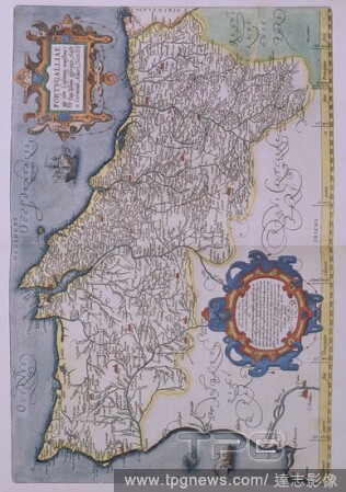
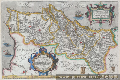
Editorial 1579, Ortelius Map of Portugal, Porvgalliae, Abraham Ortelius, also Orthellius, 1527 ? 1598, Flemish, Netherlandish cartographer and geographer.
- 2022-01-19
- 1
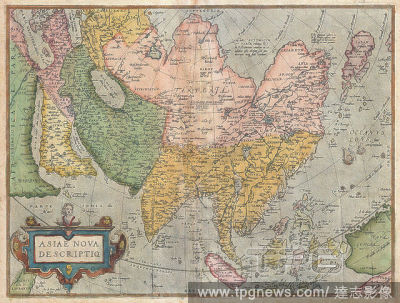
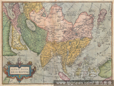
Editorial 1570, Ortelius Map of Asia, first edition, Abraham Ortelius, also Orthellius, 1527 ? 1598, Flemish, Netherlandish cartographer and geographer.
- 2022-01-19
- 1
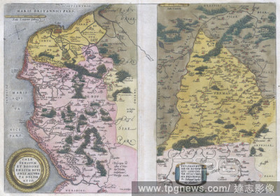
Editorial 1579, Ortelius Map of Calais and Vermandois, France and Vicinity, Abraham Ortelius, also Orthellius, 1527 ? 1598, Flemish, Netherlandish cartographer and geographer.
- 2022-01-19
- 1

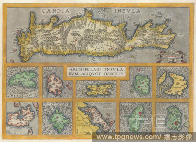
Editorial 1584, Ortelius Map of Crete, Candia and 10 Greek Islands, Abraham Ortelius, also Orthellius, 1527 ? 1598, Flemish, Netherlandish cartographer and geographer.
- 2022-01-18
- 1

Editorial Doel Ortelius Restauration Ship, Doel, Belgium - 20 Nov 2021
- 2021-11-21
- 7

Editorial Doel Ortelius Restauration Ship, Doel, Belgium - 20 Nov 2021
- 2021-11-20
- 29

Editorial Europe News - November 20, 2021
- 2021-11-20
- 33
Editorial Americae sive Novi Orbis, nova descriptio., still image, Prints, 1587 - 1595, Ortelius, Abraham (1527-1598).
- 2021-02-22
- 2

Editorial Abraham Ortelius, Map of Fezzae and Morocco, 1570, 1635, hand-colored on paper, 15 5/8 in. x 20 1/4 in. (39.69 cm x 51.44 cm).
- 2021-02-19
- 1
Editorial MAPA DE PORTUGAL-1560- CARTOGRAFIA S XVI-PERTENECIENTE AL THEATRUM ORBIS TERRARUM.
- 2021-02-19
- 3

Editorial Abraham Ortelius, frontispiece to his 'Theatrum Orbis Terrarum' - 1579 - engraving. ORTELIO ABRAHAM.
- 2020-12-04
- 1

Editorial The Mediterranean region. [Theatrvm Orbis Terrarvm. [By Abraham Ortelius. Th. Antwerp, 1595. Map of the Mediterranean. Image taken from [Theatrvm Orbis Terrarvm. [By Abraham Ortelius. The earliest, i.e. XX. Maij, MDLXX., edition, The verso of the titl...
- 2020-12-04
- 1
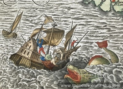
Editorial (Detail). A ship being attacked by a sea monster. [Typus orbis terrarum] (main title of album, containing 90 maps). Antwerp. 1598. Source: Maps C.2.d.7.(2).
- 2020-12-02
- 1
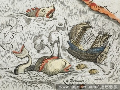
Editorial (Detail). Sea monsters attacking a ship. [Typus orbis terrarum] (main title of album, containing 90 maps). Antwerp. 1598. Source: Maps C.2.d.7.(2).
- 2020-12-02
- 1

Editorial MAPA DE TIERRA SANTA - THEATRUM ORBIS TERRARUM.
- 2020-11-30
- 1
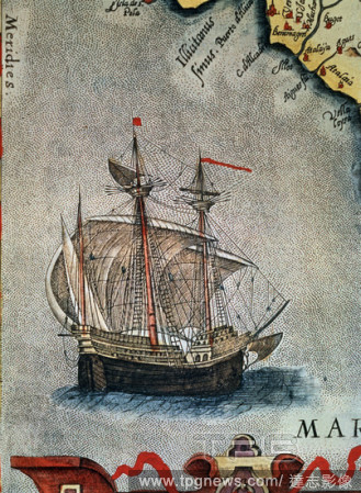
Editorial MAPA DEL REINO DE VALENCIA - DETALLE DE UN GALEON - SIGLO XVI - Detalle de la n? 6438.
- 2020-11-30
- 1

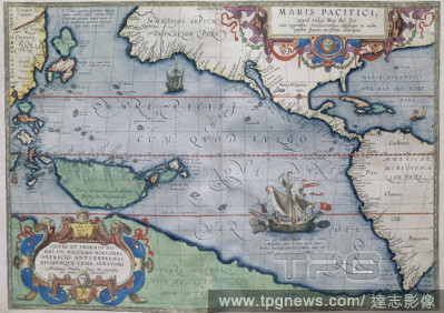
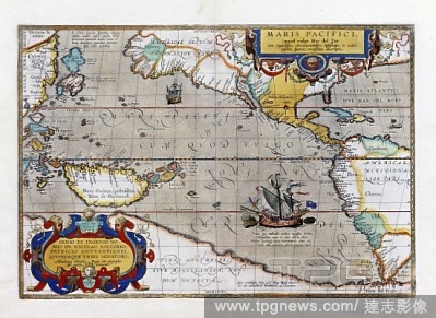
Editorial Maris Pacifici. Theatrum Orbis Terrarum. Antwerp, 1595. Map showing the Pacific Ocean and parts of North and South America. Image taken from Theatrum Orbis Terrarum. Originally published/produced in Antwerp, 1595. . Source: Maps.C.2.d.6, 6.
- 2020-11-26
- 1

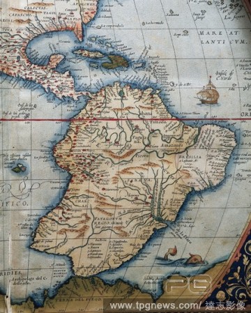
Editorial Map of Central and South America. Theatrum Orbis Terrarum by Abraham Ortelius. First Edition. 1574.
- 2020-11-26
- 1
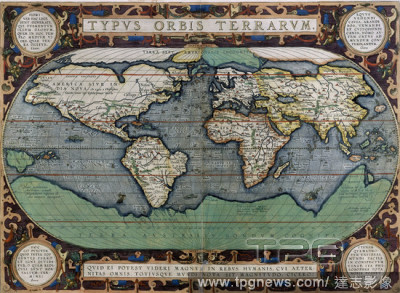
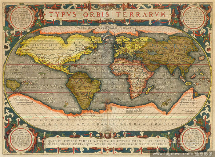
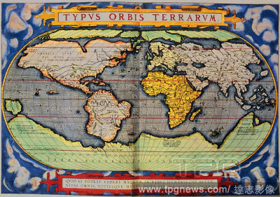
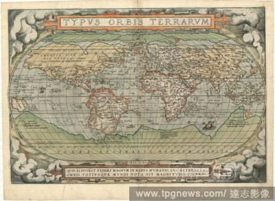
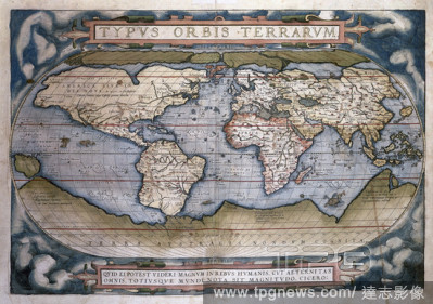
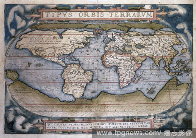
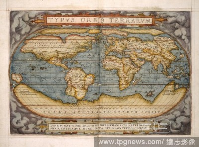
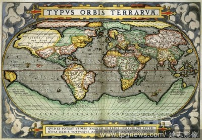
Editorial Typus Orbis Terrarum, map of the world, from Ortelius's 'Theatrum Orbis Terrarum', Antwerp - 1579 - hand-coloured engraving.
- 2020-11-26
- 1

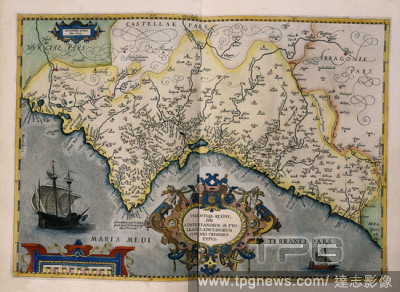
Editorial MAPA DE LA BAHIA DE CADIZ GUIPUZCOA Y MADRID 1584.
- 2020-11-26
- 2
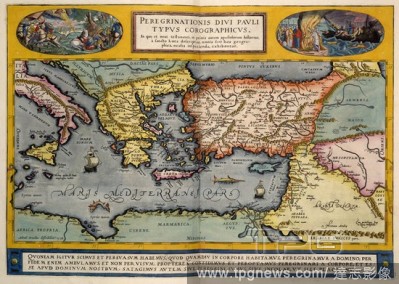
Editorial The Mediterranean region. [Theatrvm Orbis Terrarvm. [By Abraham Ortelius. Th. Antwerp, 1595. Map of the Mediterranean. Image taken from [Theatrvm Orbis Terrarvm. [By Abraham Ortelius. The earliest, i.e. XX. Maij, MDLXX., edition, The verso of the titl...
- 2020-09-28
- 1

Editorial Map of Central and South America. Theatrum Orbis Terrarum by Abraham Ortelius. First Edition. 1574.
- 2020-07-30
- 3

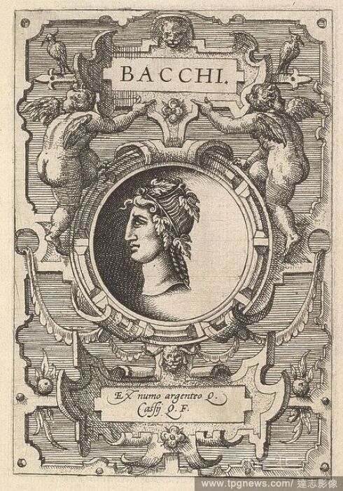
Editorial Bust of Janus surrounded by strapwork, from the series 'Deorum dearumque, ' a set of images of deities after coins in the collection of Abraham Ortelius.
- 2020-07-27
- 1
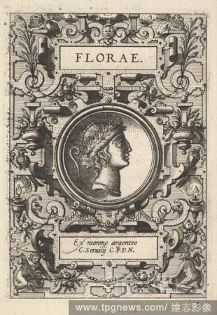
Editorial Bust of Florae surrounded by strapwork, from the series 'Deorum dearumque, ' a set of images of deities after coins in the collection of Abraham Ortelius.
- 2020-07-27
- 1
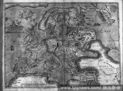
Editorial MAPA DE EUROPA Y NORTE DE AFRICA - SIGLO XVI - FOTOGRAFIA EN BLANCO Y NEGRO - A?OS 60.
- 2020-04-09
- 4
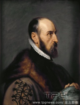
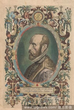
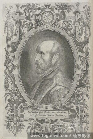
Editorial Portrait of Abraham Ortelius (1527-1598).
- 2020-01-15
- 1

Editorial Abraham Ortelius, Bronze Medal. Front: man's bust inside the inside. Reverse: snake with orbit apple crawling between stack of books within Greek inscription, Jacques Jonghelinck, Netherlands, 1598, bronze (metal), striking (metalworking), d 3.5 cm ? w...
- 2019-11-19
- 1

Editorial Bust of Janus surrounded by strapwork, from the series 'Deorum dearumque, ' a set of images of deities after coins in the collection of Abraham Ortelius.
- 2019-11-18
- 1

Editorial Bust of Florae surrounded by strapwork, from the series 'Deorum dearumque, ' a set of images of deities after coins in the collection of Abraham Ortelius.
- 2019-11-18
- 1
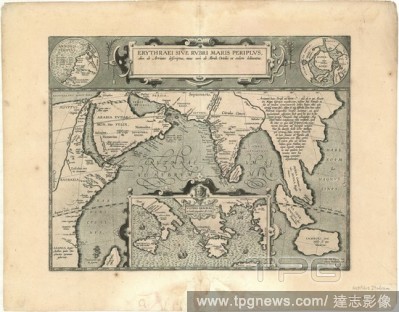
Editorial Map, Erythraei sive Rvbri Maris periplvs olim ab Arriano descriptvs, nunc vero ab Abrah. Ortelio ex eodem delineatvs, Abraham Ortelius (1527-1598), Flavius Arrianus (c.95-c.175), Copperplate print.
- 2019-11-18
- 1
Editorial Map, Oost ende West Vrieslandts beschr?vinghe, Abraham Ortelius (1527-1598), Copperplate print.
- 2019-11-18
- 1
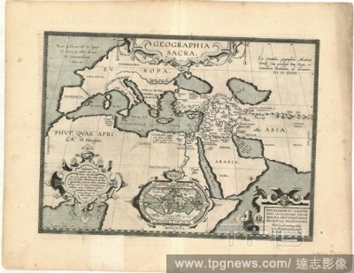
Editorial Map, Geographia sacra ex conatibus geographicis Abrahami Ortelij, Abraham Ortelius (1527-1598), Copperplate print.
- 2019-11-18
- 1
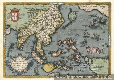
Editorial Map, Indiae Orientalis, insvlarvmque adiacientivm typvs, Abraham Ortelius (1527-1598), Copperplate print.
- 2019-11-18
- 1
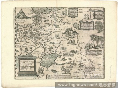
Editorial Map, Rvssiae, Moscoviae et Tartariae descriptio auctore Antonio Ienkensono Anglo, edita Londini anno 1562 & dedicata illustriss. D. Henrico S?dneo Wallie presidi, Anthony Jenkinson (-1611), Abraham Ortelius (1527-1598), Copperplate print.
- 2019-11-18
- 1
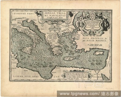
Editorial Map, Aeneae Troiani Navigatio Ad Virgilij sex priores Aeneidos, Abraham Ortelius (1527-1598), Copperplate print.
- 2019-11-18
- 1
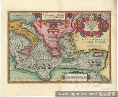
Editorial Map, Aeneae Troiani Navigatio Ad Virgilij sex priores Aeneidos, Abraham Ortelius (1527-1598), Copperplate print.
- 2019-11-18
- 1
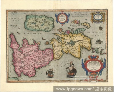
Editorial Map, Britannicarvm Insvlarvm typvs, Abraham Ortelius (1527-1598), Copperplate print.
- 2019-11-18
- 1
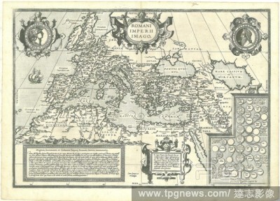
Editorial Map, Romani Imperii imago, Abraham Ortelius (1527-1598), Copperplate print.
- 2019-11-18
- 1
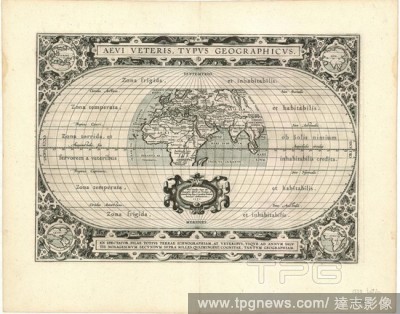
Editorial Map, Aevi veteris, typvs geographicvs Ortelius, Abraham Ortelius (1527-1598), Copperplate print.
- 2019-11-18
- 1
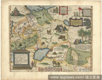
Editorial Map, Rvssiae, Moscoviae et Tartariae descriptio auctore Antonio Ienkensono Anglo, edita Londini anno 1562 & dedicata illustriss. D. Henrico S?dneo Wallie presidi, Anthony Jenkinson (-1611), Abraham Ortelius (1527-1598), Copperplate print.
- 2019-11-18
- 1
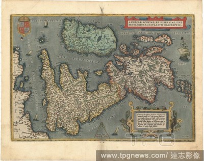
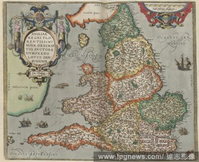
Editorial Map, Angliae, Scotiae et Hiberniae, sive Britannicar. insularum descriptio, Abraham Ortelius (1527-1598), Copperplate print.
- 2019-11-18
- 1
Editorial Map, Typus orbis terrarum Franciscus Hogenbergus sculpsit, Frans Hogenberg (1535-1590), Abraham Ortelius (1527-1598), Copperplate print.
- 2019-11-18
- 1

Editorial Map, Romani Imperii imago, Abraham Ortelius (1527-1598), Copperplate print.
- 2019-11-18
- 1

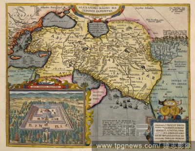
Editorial Map, Alexandri Magni Macedonis expeditio ex conatib. geographicis Ab. Ortelij, Abraham Ortelius (1527-1598), Copperplate print.
- 2019-11-18
- 1
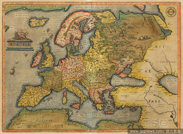
Editorial Theatrum Orbis Terrarum (Theatre of the World). Is considered to be the first true modern atlas. Written by Abraham Ortelius and originally printed on May 20, 1570, in Antwerp. World Map.
- 2019-08-02
- 1
Editorial MAPA DE EUROPA Y NORTE DE AFRICA - SIGLO XVI.
- 2019-08-02
- 1

Editorial MAPA SUR EUROPA Y NORTE AFRICA-ORB.TERRARUM-1570-.
- 2019-08-02
- 1
Editorial MAPA DEL OCEANO PACIFICO - 1589.
- 2019-08-02
- 2

Editorial MAPA DE HOLANDA - SIGLO XVI.
- 2019-08-02
- 1
Editorial World map. 1579. Madrid, Geographic department of the Army.
- 2019-08-02
- 1
Editorial Map of Valencia kingdom. 1584. Madrid, Geographical service of the army.
- 2019-08-02
- 2

Editorial Map of Central and South America. Theatrum Orbis Terrarum by Abraham Ortelius. First Edition. 1574.
- 2019-04-09
- 1
Editorial Map of Pacific Ocean with New Guinea and South America showing Magellan's ship Victoria from Theatrum Orbis Terrarum by Abraham Ortelius. Theatrum Orbis Terrarum ("Theatre of the World") is considered to be the first true modern atlas. Written by Abrah...
- 2019-03-20
- 1
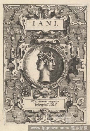
Editorial Bust of Janus surrounded by strapwork, from the series 'Deorum dearumque, ' a set of images of deities after coins in the collection of Abraham Ortelius.
- 2019-02-22
- 1

Editorial Bust of Florae surrounded by strapwork, from the series 'Deorum dearumque, ' a set of images of deities after coins in the collection of Abraham Ortelius.
- 2019-02-22
- 1

Editorial Maris Pacifici. Theatrum Orbis Terrarum. Antwerp, 1595. Map showing the Pacific Ocean and parts of North and South America. Image taken from Theatrum Orbis Terrarum. Originally published/produced in Antwerp, 1595. . Source: Maps.C.2.d.6, 6.
- 2019-01-24
- 1
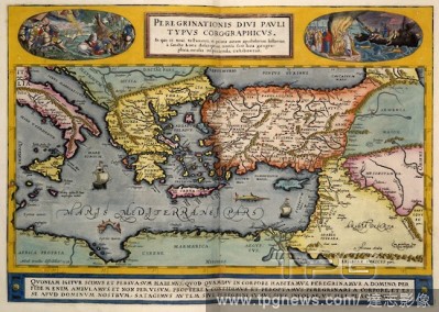
Editorial The Mediterranean region. [Theatrvm Orbis Terrarvm. [By Abraham Ortelius. Th. Antwerp, 1595. Map of the Mediterranean. Image taken from [Theatrvm Orbis Terrarvm. [By Abraham Ortelius. The earliest, i.e. XX. Maij, MDLXX., edition, The verso of the titl...
- 2019-01-24
- 1

Editorial El Escorial.
- 2019-01-24
- 1
Editorial 1579, Ortelius Map of Portugal, Porvgalliae, Abraham Ortelius, also Orthellius, 1527 ? 1598, Flemish, Netherlandish cartographer and geographer.
- 2019-01-23
- 1
Editorial 1570, Ortelius Map of Asia, first edition, Abraham Ortelius, also Orthellius, 1527 ? 1598, Flemish, Netherlandish cartographer and geographer.
- 2019-01-23
- 1
Editorial 1584, Ortelius Map of Crete, Candia and 10 Greek Islands, Abraham Ortelius, also Orthellius, 1527 ? 1598, Flemish, Netherlandish cartographer and geographer.
- 2019-01-23
- 1
Editorial 1579, Ortelius Map of Calais and Vermandois, France and Vicinity, Abraham Ortelius, also Orthellius, 1527 ? 1598, Flemish, Netherlandish cartographer and geographer.
- 2019-01-23
- 1
Editorial Theatrum Orbis Terrarum (Theatre of the World). Is considered to be the first true modern atlas. Written by Abraham Ortelius and originally printed on May 20, 1570, in Antwerp. World Map.
- 2019-01-23
- 1
Editorial Map of Central and South America. Theatrum Orbis Terrarum by Abraham Ortelius (1527-1598). First Edition. Antwerp, 1574.
- 2018-12-21
- 1
Editorial World map. Theatrum Orbis Terrarum. Antwerp, 1570. Source: Maps.C.2.c.3,.
- 2018-12-06
- 1
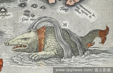
Editorial (Detail). A sea monster. [Typus orbis terrarum] (main title of album, containing 90 maps). Antwerp. 1598. Source: Maps C.2.d.7.(2).
- 2018-12-06
- 1
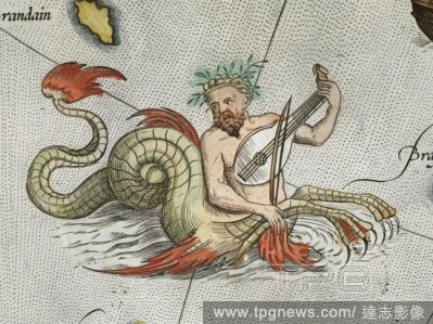
Editorial (Detail). A merman, playing an instrument. [Typus orbis terrarum] (main title of album, containing 90 maps). Antwerp. 1598. Source: Maps C.2.d.7.(2).
- 2018-12-06
- 1
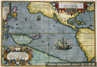
Editorial Maris Pacifici. Theatrum Orbis Terrarum. Antwerp, 1595. Map showing the Pacific Ocean and parts of North and South America. Image taken from Theatrum Orbis Terrarum. Originally published/produced in Antwerp, 1595. . Source: Maps.C.2.d.6, 6.
- 2018-12-06
- 1
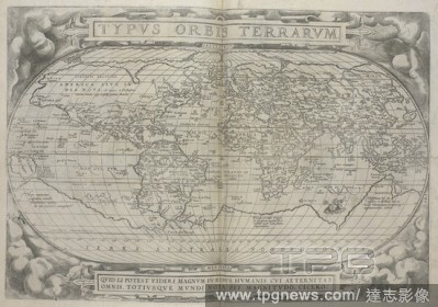
Editorial Typvs orbis terrarvm. 16th century world map by Ortelius. . Theatrvm Orbis Terrarvm. Anvers : De l'Imprimerie de Christofle Plantin, pour Abraham Ortel, autheur mesme de ce liure, 1587. Source: Maps.C.2.d.2 before page 2.
- 2018-12-06
- 1
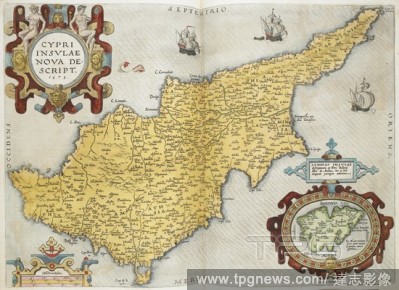
Editorial A map of Cyprus. Theatrum oder Schawbüch des Erdtkreijs. [In Antorff] : [bey Christoffel Plantin, in verlegung Abraham Ortell] , [1597]. Source: Maps C.49.e.58.
- 2018-12-06
- 1
Editorial World Map. Typus Orbis Terrarum. Atlas Sive Cosmographica. Antwerp, 1598. Source: Maps.C.2.d.7, 1-2.
- 2018-12-06
- 1
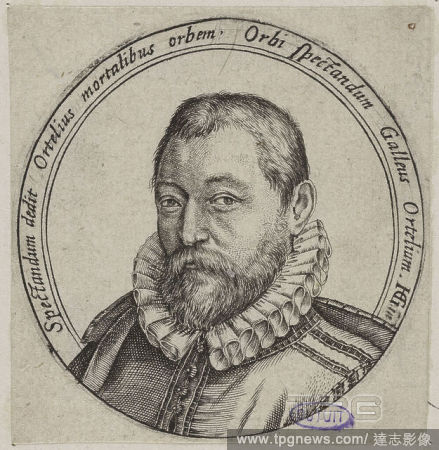
Editorial Abraham Ortelius (Ortels), (14 April 1527 – 28 June 1598). A Flemish cartographer and geographer. . Theatrvm Orbis Terrarvm. (Theatrum Orbis Terrarum.). Anvers : De l'Imprimerie de Christofle Plantin, pour Abraham Ortel, autheur mesme de ce liure, 15...
- 2018-12-06
- 1
Editorial Asia. [Theatrvm Orbis Terrarvm. [By Abraham Ortelius. Th. Antwerp, 1595. Map of Asia. Image taken from [Theatrvm Orbis Terrarvm. [By Abraham Ortelius. The earliest, i.e. XX. Maij, MDLXX., edition, The verso of the title blank. Originally published/pr...
- 2018-12-06
- 1

Editorial Title page of 'An Epitome of Ortelius his Theatre of the World'. An Epitome of Ortelius his Theatre of the World ... With new Mappes wanting in the Latin editions. London : J. Norton, [1610]. Source: Maps C.2.b.11, title page. Language: English.
- 2018-12-06
- 1
Editorial A 16th century map of England. [Typus orbis terrarum]. Antwerp, 1598. Source: Maps.C.2.D.7 map 11.
- 2018-12-06
- 1
 Loading