
filter
-
Brand
- By Category
- Direction
- Date Range
78Events
Pictures
Events

Editorial PA: Abortion Rights Rally in Williamsport
- 2024-06-25
- 15

Editorial US-NEWS-CMP-SACSTATE-FRATERNITY-SA
- 2023-11-21
- 1

Editorial US-NEWS-CMP-SACSTATE-FRATERNITY-SA
- 2023-06-11
- 6

Editorial Then-President Donald Trump attends a campaign rally at the Williamsport Regional Airport in Montoursville, Pa., Oct. 31, 2020. (Anna Moneymaker/The New York Times)
- 2023-01-16
- 5

Editorial PA: Holiday Shopping
- 2022-11-22
- 5

Editorial Students return to Bloomsburg University in US - 15 Aug 2021
- 2021-08-16
- 1

Editorial PA: Juneteenth Celebration in Williamsport
- 2021-06-20
- 10

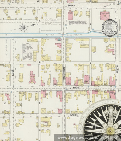
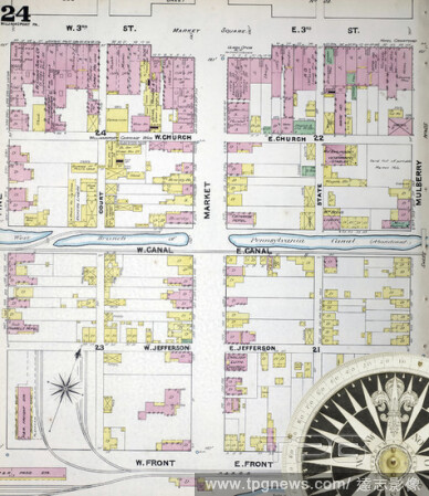
Editorial Image 10 of Sanborn Fire Insurance Map from Williamsport, Lycoming County, Pennsylvania. 1891. 56 Sheet(s). Bound, America, street map with a Nineteenth Century compass.
- 2021-02-20
- 1

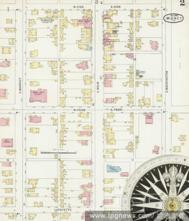
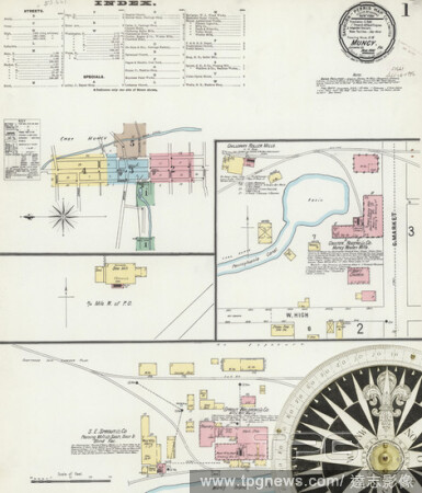
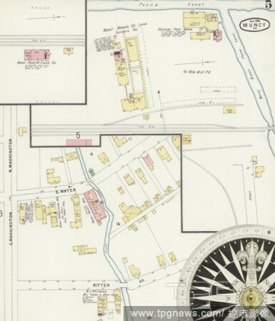
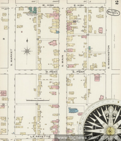
Editorial Image 1 of Sanborn Fire Insurance Map from Muncy, Lycoming County, Pennsylvania. Sep 1890. 5 Sheet(s), America, street map with a Nineteenth Century compass.
- 2021-02-20
- 1
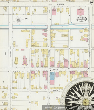
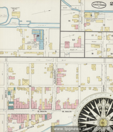
Editorial Image 1 of Sanborn Fire Insurance Map from Jersey Shore, Lycoming County, Pennsylvania. Oct 1891. 2 Sheet(s), America, street map with a Nineteenth Century compass.
- 2021-02-20
- 1
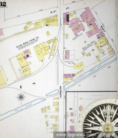
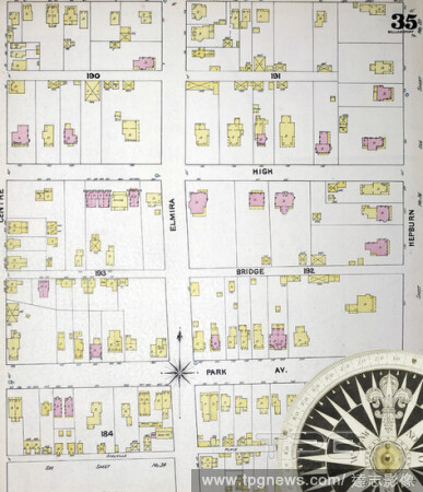
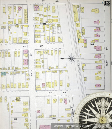
Editorial Image 32 of Sanborn Fire Insurance Map from Williamsport, Lycoming County, Pennsylvania. 1891. 56 Sheet(s). Bound, America, street map with a Nineteenth Century compass.
- 2021-02-20
- 1
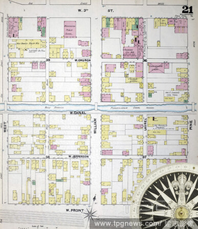
Editorial Image 21 of Sanborn Fire Insurance Map from Williamsport, Lycoming County, Pennsylvania. 1891. 56 Sheet(s). Bound, America, street map with a Nineteenth Century compass.
- 2021-02-20
- 1
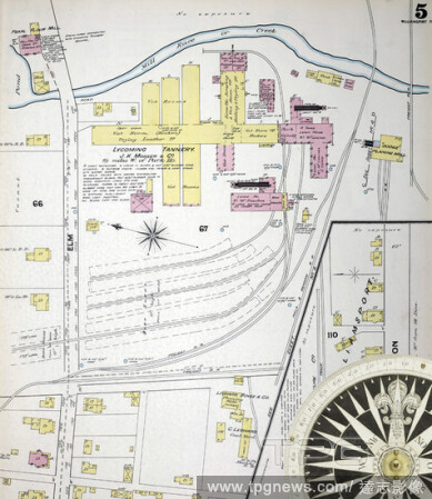
Editorial Image 5 of Sanborn Fire Insurance Map from Williamsport, Lycoming County, Pennsylvania. 1891. 56 Sheet(s). Bound, America, street map with a Nineteenth Century compass.
- 2021-02-20
- 1
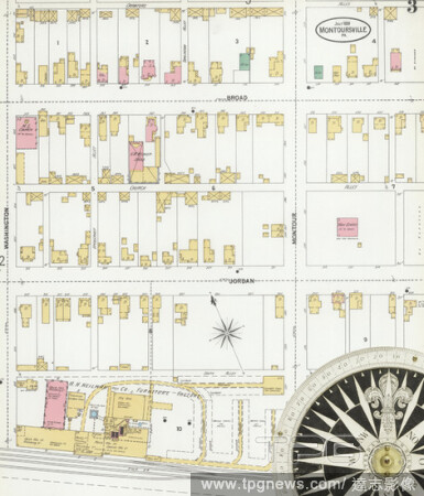
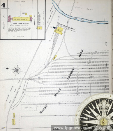
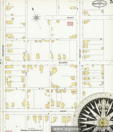
Editorial Image 3 of Sanborn Fire Insurance Map from Montoursville, Lycoming County, Pennsylvania. Jul 1899. 7 Sheet(s), America, street map with a Nineteenth Century compass.
- 2021-02-20
- 1
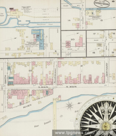
Editorial Image 2 of Sanborn Fire Insurance Map from Jersey Shore, Lycoming County, Pennsylvania. Oct 1885. 2 Sheet(s), America, street map with a Nineteenth Century compass.
- 2021-02-20
- 1

Editorial Image 4 of Sanborn Fire Insurance Map from Muncy, Lycoming County, Pennsylvania. Sep 1890. 5 Sheet(s), America, street map with a Nineteenth Century compass.
- 2021-02-20
- 1
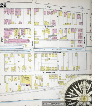
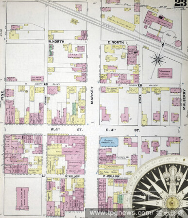
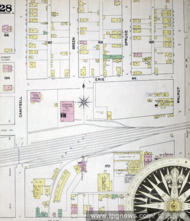
Editorial Image 26 of Sanborn Fire Insurance Map from Williamsport, Lycoming County, Pennsylvania. 1891. 56 Sheet(s). Bound, America, street map with a Nineteenth Century compass.
- 2021-02-20
- 1

Editorial Image 38 of Sanborn Fire Insurance Map from Williamsport, Lycoming County, Pennsylvania. 1891. 56 Sheet(s). Bound, America, street map with a Nineteenth Century compass.
- 2021-02-20
- 1
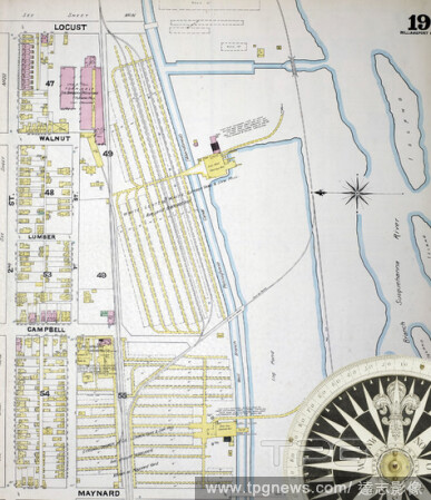
Editorial Image 19 of Sanborn Fire Insurance Map from Williamsport, Lycoming County, Pennsylvania. 1891. 56 Sheet(s). Bound, America, street map with a Nineteenth Century compass.
- 2021-02-20
- 1
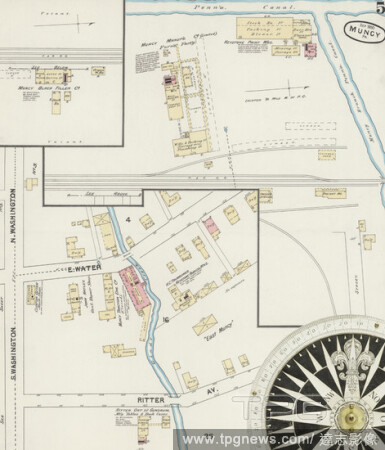
Editorial Image 2 of Sanborn Fire Insurance Map from Muncy, Lycoming County, Pennsylvania. Aug 1896. 5 Sheet(s), America, street map with a Nineteenth Century compass.
- 2021-02-20
- 1
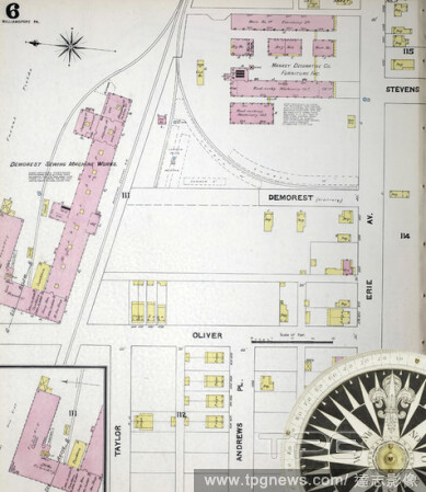
Editorial Image 6 of Sanborn Fire Insurance Map from Williamsport, Lycoming County, Pennsylvania. 1891. 56 Sheet(s). Bound, America, street map with a Nineteenth Century compass.
- 2021-02-20
- 1
Editorial Image 30 of Sanborn Fire Insurance Map from Williamsport, Lycoming County, Pennsylvania. 1891. 56 Sheet(s). Bound, America, street map with a Nineteenth Century compass.
- 2021-02-20
- 2
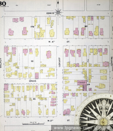
Editorial Image 14 of Sanborn Fire Insurance Map from Williamsport, Lycoming County, Pennsylvania. 1891. 56 Sheet(s). Bound, America, street map with a Nineteenth Century compass.
- 2021-02-20
- 1
Editorial Image 23 of Sanborn Fire Insurance Map from Williamsport, Lycoming County, Pennsylvania. 1891. 56 Sheet(s). Bound, America, street map with a Nineteenth Century compass.
- 2021-02-20
- 1
Editorial Image 4 of Sanborn Fire Insurance Map from Williamsport, Lycoming County, Pennsylvania. 1891. 56 Sheet(s). Bound, America, street map with a Nineteenth Century compass.
- 2021-02-20
- 1
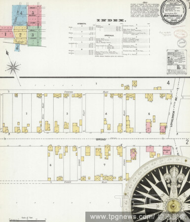
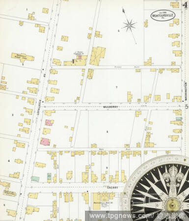
Editorial Image 1 of Sanborn Fire Insurance Map from Montoursville, Lycoming County, Pennsylvania. Jul 1899. 7 Sheet(s), America, street map with a Nineteenth Century compass.
- 2021-02-20
- 1

Editorial Image 6 of Sanborn Fire Insurance Map from Montoursville, Lycoming County, Pennsylvania. Jul 1899. 7 Sheet(s), America, street map with a Nineteenth Century compass.
- 2021-02-20
- 2

Editorial Image 1 of Sanborn Fire Insurance Map from Muncy, Lycoming County, Pennsylvania. Oct 1885. 3 Sheet(s), America, street map with a Nineteenth Century compass.
- 2021-02-20
- 1
Editorial Image 8 of Sanborn Fire Insurance Map from Williamsport, Lycoming County, Pennsylvania. 1891. 56 Sheet(s). Bound, America, street map with a Nineteenth Century compass.
- 2021-02-20
- 1
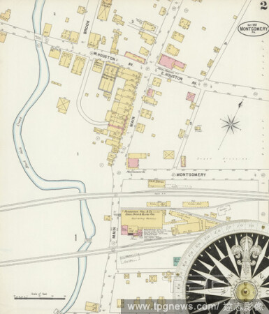
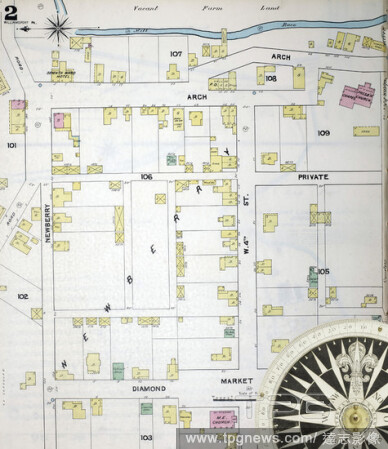
Editorial Image 2 of Sanborn Fire Insurance Map from Montgomery, Lycoming County, Pennsylvania. May 1897. 3 Sheet(s), America, street map with a Nineteenth Century compass.
- 2021-02-20
- 1

Editorial Image 31 of Sanborn Fire Insurance Map from Williamsport, Lycoming County, Pennsylvania. 1891. 56 Sheet(s). Bound, America, street map with a Nineteenth Century compass.
- 2021-02-20
- 1
Editorial Image 5 of Sanborn Fire Insurance Map from Muncy, Lycoming County, Pennsylvania. Sep 1890. 5 Sheet(s), America, street map with a Nineteenth Century compass.
- 2021-02-20
- 1

Editorial Image 1 of Sanborn Fire Insurance Map from Jersey Shore, Lycoming County, Pennsylvania. Sep 1896. 3 Sheet(s), America, street map with a Nineteenth Century compass.
- 2021-02-20
- 1

Editorial Image 3 of Sanborn Fire Insurance Map from Jersey Shore, Lycoming County, Pennsylvania. Sep 1896. 3 Sheet(s), America, street map with a Nineteenth Century compass.
- 2021-02-20
- 1
Editorial Image 3 of Sanborn Fire Insurance Map from Muncy, Lycoming County, Pennsylvania. Aug 1896. 5 Sheet(s), America, street map with a Nineteenth Century compass.
- 2021-02-20
- 1
Editorial Image 4 of Sanborn Fire Insurance Map from Muncy, Lycoming County, Pennsylvania. Aug 1896. 5 Sheet(s), America, street map with a Nineteenth Century compass.
- 2021-02-19
- 2
Editorial Image 35 of Sanborn Fire Insurance Map from Williamsport, Lycoming County, Pennsylvania. 1891. 56 Sheet(s). Bound, America, street map with a Nineteenth Century compass.
- 2021-02-19
- 2
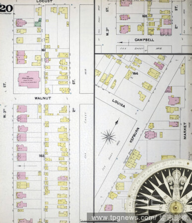
Editorial Image 20 of Sanborn Fire Insurance Map from Williamsport, Lycoming County, Pennsylvania. 1891. 56 Sheet(s). Bound, America, street map with a Nineteenth Century compass.
- 2021-02-19
- 2

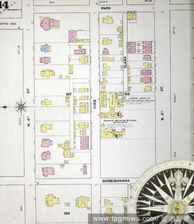
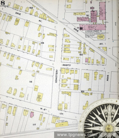
Editorial Image 17 of Sanborn Fire Insurance Map from Williamsport, Lycoming County, Pennsylvania. 1891. 56 Sheet(s). Bound, America, street map with a Nineteenth Century compass.
- 2021-02-19
- 4
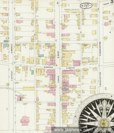
Editorial Image 1 of Sanborn Fire Insurance Map from Muncy, Lycoming County, Pennsylvania. Aug 1896. 5 Sheet(s), America, street map with a Nineteenth Century compass.
- 2021-02-19
- 2
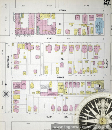
Editorial Image 27 of Sanborn Fire Insurance Map from Williamsport, Lycoming County, Pennsylvania. 1891. 56 Sheet(s). Bound, America, street map with a Nineteenth Century compass.
- 2021-02-19
- 2
Editorial Image 13 of Sanborn Fire Insurance Map from Williamsport, Lycoming County, Pennsylvania. 1891. 56 Sheet(s). Bound, America, street map with a Nineteenth Century compass.
- 2021-02-19
- 2
Editorial Image 28 of Sanborn Fire Insurance Map from Williamsport, Lycoming County, Pennsylvania. 1891. 56 Sheet(s). Bound, America, street map with a Nineteenth Century compass.
- 2021-02-19
- 2

Editorial Image 7 of Sanborn Fire Insurance Map from Montoursville, Lycoming County, Pennsylvania. Jul 1899. 7 Sheet(s), America, street map with a Nineteenth Century compass.
- 2021-02-19
- 2

Editorial Image 3 of Sanborn Fire Insurance Map from Muncy, Lycoming County, Pennsylvania. Sep 1890. 5 Sheet(s), America, street map with a Nineteenth Century compass.
- 2021-02-19
- 2
Editorial Image 5 of Sanborn Fire Insurance Map from Muncy, Lycoming County, Pennsylvania. Aug 1896. 5 Sheet(s), America, street map with a Nineteenth Century compass.
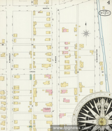
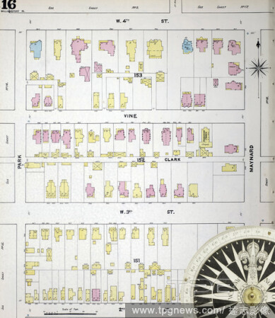
- 2021-02-19
- 4
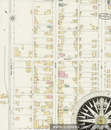
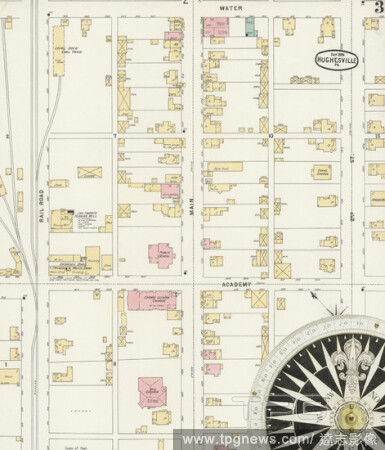
Editorial Image 2 of Sanborn Fire Insurance Map from Hughesville, Lycoming County, Pennsylvania. Sep 1896. 3 Sheet(s), America, street map with a Nineteenth Century compass.
- 2021-02-19
- 2

Editorial Image 29 of Sanborn Fire Insurance Map from Williamsport, Lycoming County, Pennsylvania. 1891. 56 Sheet(s). Bound, America, street map with a Nineteenth Century compass.
- 2021-02-19
- 2

Editorial Image 1 of Sanborn Fire Insurance Map from Montgomery, Lycoming County, Pennsylvania. May 1897. 3 Sheet(s), America, street map with a Nineteenth Century compass.
- 2021-02-19
- 2
Editorial Image 2 of Sanborn Fire Insurance Map from Jersey Shore, Lycoming County, Pennsylvania. Sep 1896. 3 Sheet(s), America, street map with a Nineteenth Century compass.
- 2021-02-19
- 2

Editorial Image 25 of Sanborn Fire Insurance Map from Williamsport, Lycoming County, Pennsylvania. 1891. 56 Sheet(s). Bound, America, street map with a Nineteenth Century compass.
- 2021-02-19
- 2
Editorial Image 16 of Sanborn Fire Insurance Map from Williamsport, Lycoming County, Pennsylvania. 1891. 56 Sheet(s). Bound, America, street map with a Nineteenth Century compass.
- 2021-02-19
- 2

Editorial Image 34 of Sanborn Fire Insurance Map from Williamsport, Lycoming County, Pennsylvania. 1891. 56 Sheet(s). Bound, America, street map with a Nineteenth Century compass.
- 2021-02-19
- 2
Editorial Image 5 of Sanborn Fire Insurance Map from Montoursville, Lycoming County, Pennsylvania. Jul 1899. 7 Sheet(s), America, street map with a Nineteenth Century compass.
- 2021-02-19
- 2
Editorial Image 2 of Sanborn Fire Insurance Map from Williamsport, Lycoming County, Pennsylvania. 1891. 56 Sheet(s). Bound, America, street map with a Nineteenth Century compass.
- 2021-02-19
- 2

Editorial Image 7 of Sanborn Fire Insurance Map from Williamsport, Lycoming County, Pennsylvania. 1891. 56 Sheet(s). Bound, America, street map with a Nineteenth Century compass.
- 2021-02-19
- 2

Editorial Image 18 of Sanborn Fire Insurance Map from Williamsport, Lycoming County, Pennsylvania. 1891. 56 Sheet(s). Bound, America, street map with a Nineteenth Century compass.
- 2021-02-19
- 2
Editorial Image 2 of Sanborn Fire Insurance Map from Jersey Shore, Lycoming County, Pennsylvania. Oct 1891. 2 Sheet(s), America, street map with a Nineteenth Century compass.
- 2021-02-19
- 2
Editorial Image 3 of Sanborn Fire Insurance Map from Williamsport, Lycoming County, Pennsylvania. 1891. 56 Sheet(s). Bound, America, street map with a Nineteenth Century compass.
- 2021-02-19
- 2
Editorial Image 3 of Sanborn Fire Insurance Map from Montgomery, Lycoming County, Pennsylvania. May 1897. 3 Sheet(s), America, street map with a Nineteenth Century compass.
- 2021-02-19
- 2

Editorial Image 1 of Sanborn Fire Insurance Map from Williamsport, Lycoming County, Pennsylvania. 1891. 56 Sheet(s). Bound, America, street map with a Nineteenth Century compass.
- 2021-02-19
- 2

Editorial Image 36 of Sanborn Fire Insurance Map from Williamsport, Lycoming County, Pennsylvania. 1891. 56 Sheet(s). Bound, America, street map with a Nineteenth Century compass.
- 2021-02-19
- 2

Editorial Image 37 of Sanborn Fire Insurance Map from Williamsport, Lycoming County, Pennsylvania. 1891. 56 Sheet(s). Bound, America, street map with a Nineteenth Century compass.
- 2021-02-19
- 2
Editorial Image 2 of Sanborn Fire Insurance Map from Montoursville, Lycoming County, Pennsylvania. Jul 1899. 7 Sheet(s), America, street map with a Nineteenth Century compass.
- 2021-02-19
- 2
Editorial Image 3 of Sanborn Fire Insurance Map from Hughesville, Lycoming County, Pennsylvania. Sep 1896. 3 Sheet(s), America, street map with a Nineteenth Century compass.
- 2021-02-19
- 1

Editorial Image 33 of Sanborn Fire Insurance Map from Williamsport, Lycoming County, Pennsylvania. 1891. 56 Sheet(s). Bound, America, street map with a Nineteenth Century compass.
- 2021-02-19
- 1
Editorial Image 4 of Sanborn Fire Insurance Map from Montoursville, Lycoming County, Pennsylvania. Jul 1899. 7 Sheet(s), America, street map with a Nineteenth Century compass.
- 2021-02-19
- 1
Editorial Image 24 of Sanborn Fire Insurance Map from Williamsport, Lycoming County, Pennsylvania. 1891. 56 Sheet(s). Bound, America, street map with a Nineteenth Century compass.
- 2021-02-19
- 1
Editorial Image 2 of Sanborn Fire Insurance Map from Muncy, Lycoming County, Pennsylvania. Oct 1885. 3 Sheet(s), America, street map with a Nineteenth Century compass.
- 2021-02-19
- 1

Editorial Image 39 of Sanborn Fire Insurance Map from Williamsport, Lycoming County, Pennsylvania. 1891. 56 Sheet(s). Bound, America, street map with a Nineteenth Century compass.
- 2021-02-19
- 1

Editorial Image 40 of Sanborn Fire Insurance Map from Williamsport, Lycoming County, Pennsylvania. 1891. 56 Sheet(s). Bound, America, street map with a Nineteenth Century compass.
- 2021-02-19
- 1

Editorial Image 1 of Sanborn Fire Insurance Map from Jersey Shore, Lycoming County, Pennsylvania. Oct 1885. 2 Sheet(s), America, street map with a Nineteenth Century compass.
- 2021-02-19
- 1

Editorial Image 11 of Sanborn Fire Insurance Map from Williamsport, Lycoming County, Pennsylvania. 1891. 56 Sheet(s). Bound, America, street map with a Nineteenth Century compass.
- 2021-02-19
- 1

Editorial Image 3 of Sanborn Fire Insurance Map from Muncy, Lycoming County, Pennsylvania. Oct 1885. 3 Sheet(s), America, street map with a Nineteenth Century compass.
- 2021-02-19
- 2

Editorial PA: Lycoming County Trump Train Road Rally
- 2020-11-02
- 11
 Loading