
filter
-
Brand
- By Category
- Direction
- Date Range
371Events
Pictures
Events
Editorial
- 2024-09-10
- 1
Editorial
- 2023-11-01
- 1

Editorial
- 2023-11-01
- 1
Editorial
- 2023-11-01
- 1
Editorial
- 2023-11-01
- 1
Editorial
- 2023-11-01
- 1
Editorial
- 2023-11-01
- 2
Editorial
- 2023-11-01
- 1
Editorial
- 2023-11-01
- 1
Editorial
- 2023-11-01
- 1
Editorial
- 2023-11-01
- 1

Editorial
- 2023-06-15
- 1
Editorial
- 2023-06-15
- 1

Editorial
- 2023-06-15
- 1

Editorial
- 2023-06-15
- 1
Editorial
- 2023-06-15
- 1
Editorial
- 2023-06-07
- 1
Editorial
- 2023-06-07
- 1
Editorial
- 2023-06-07
- 1

Editorial 85th Battalion, CEF, Nova Scotia Highlanders. Lieut. Colonel A.H. Bordon, OC, 1916.
- 2022-12-24
- 1
Editorial Officers and men of No. 9 Stationary Hospital CEF St. Francis Xavier's Unit, Lieut-Col. McLeod OC, 1916.
- 2022-12-24
- 1
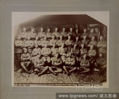
Editorial Lieut. Magee, Non Coms, and men of No, 4 Troop A Squadron, Strathcona's Horse, Ottawa. No. 59163a, 1900.
- 2022-12-24
- 1
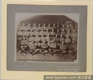
Editorial Lieut. Magee, Non Coms, and men of No, 4 Troop A Squadron, Strathcona's Horse, Ottawa. No. 59163a, 1900.
- 2022-12-24
- 1

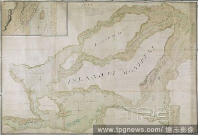
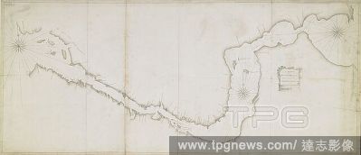
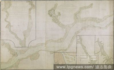
Editorial A plan of the St. Lawrence River from Montreal to Berthier on the North, and to Sorel on the South side of the River. A PLAN of the RIVER ST. LAURENCE from MONTREAL TO BERTHIER ON THE NORTH and to SOREL ON THE SOUTH SIDE OF THE RIVER; being part OF A S...
- 2022-12-24
- 1
Editorial Plan of the River Saint Lawrence from Montreal to the Parish of Berthier on the North side of the River, and Sorel on the South. [Halifax?] : by John Montresor Sub. Engineer & Lieut. Samuel Holland Capt. and Asting Engr., [between 1758 and 1763.]. Sour...
- 2022-12-24
- 1
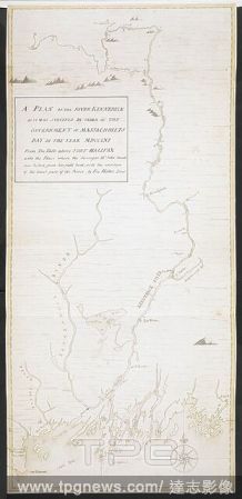
Editorial A plan of the River Kennebeck as it was surveyed by order of the Government of Massachusets Bay in the year MDCCLXI from the falls above Halifax unto the place where the surveyor John Small was killed, from his field book, with the addition of lower pa...
- 2022-12-24
- 1
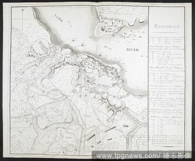
Editorial Plan of Yorktown, showing disposition of American, French and British forces. Drawn by Juliana 12th June 1782 & John Hoyman, Lieut. Inscribed as copy. PLANS of military operations, in North America, etc. 1716-1783. Source: Add. 15535.
- 2022-12-24
- 1
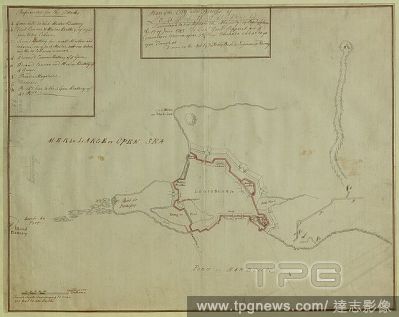
Editorial A plan of the City and Fortress of Louisbourg. Plan of the City and Fortress of LOUISBOURG Surrendered to his Britanick Majesty by Capitulation the 17 June 1745. to Lieut. Genl. Pepperel and Commodore Warren after 55 Days Blockade and 42 days open Tren...
- 2022-12-24
- 1

Editorial A view from Boston looking south, with a British soldier holding a bayonet standing by a cannon in a battery on top of Beacon Hill in the foreground. Boston rooftops can be seen beyond the palisade with Castle William on the left, Dorchester Point and ...
- 2022-12-24
- 1

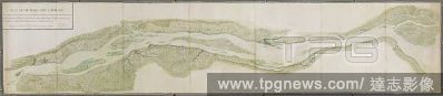
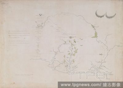
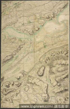
Editorial A plan of part of Canada and the St. Lawrence River which lies between Dechambeaux and Pointe du Lac. The map includes four inset plans; a continuation of the Chaudière River at upper left, two further continuations at lower right, and also an inset p...
- 2022-12-24
- 1
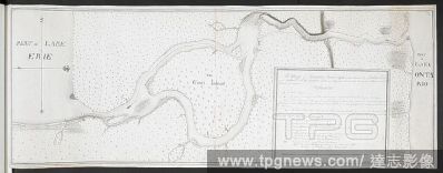
Editorial A map of Niagara River May 1760'. Part of Lake Erie. . 'A map of Niagara River May 1760 Geo. Demler Lieut 60th Regimt'. 1:63360. 'Scale of 8 miles' (= 8 inches). Map oriented with West at top. Amherst no. A 55. R.U.S.I. no. A 27.33A. Laid down in the m...
- 2022-12-24
- 1

Editorial A plan of Massachusetts Bay and part of the River Penobscot. MAY 23. 1759. PROVINCE MASSACHUSETTS BAY PENOBSCOT DOMINIONS OF GREAT BRITAIN POSSESSION CONFIRM'D BY THOS. POWNALL GOVR. [Place of production not identified] : [by --- Jones, Capt. North, of...
- 2022-12-24
- 1
Editorial Plan of that part of Canada and the River St. Lawrence, which lies between the Coteau des Cedres (the uppermost settlements of Canada) and the Island of St. Therese... [Quebec?] : Capt. Holland of the Royal American Regiment ... Lieut. Montresor Engine...
- 2022-12-24
- 1
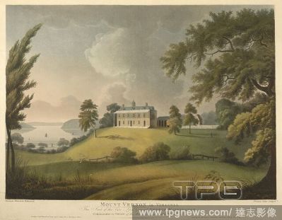
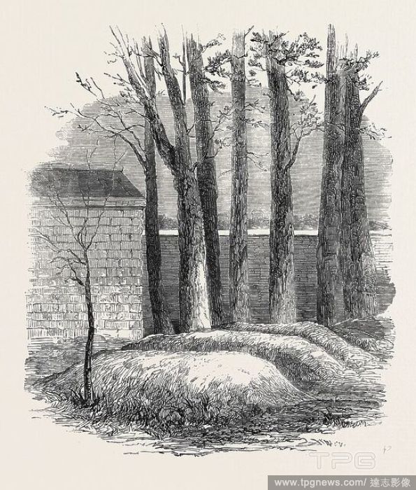
Editorial A view of the Eastern fa?ade of George Washington's two-storey country house with a veranda, colonnade, hipped roof, cupola and dormers built on a mound surrounded by landscaped grounds. Sailing ships can be seen on Potomac River in the background on ...
- 2022-12-24
- 1

Editorial A chart of the north west coast of America and the north east coast of Asia. Chart of the N. W. Coast of America and the N. E. Coast of Asia explored in the years 1778 and 1779. Prepared by Lieut. H. Roberts, under the immediate inspection of Capt. Coo...
- 2022-12-24
- 1
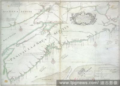
Editorial A chart of the peninsula of Nova Scotia. A CHART OF THE PENINSULA OF NOVA SCOTIA / done by order of His Excellency CHS. LAWRENCE Esqr. Lieut. Govr. & Commr. in Chief of his Majesty's Province of NOVA SCOTIA from many actual Surveys; and the whole corre...
- 2022-12-24
- 1
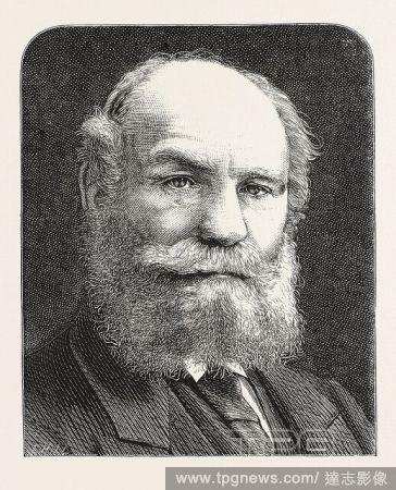
Editorial THE LATE LIEUT.-COL. THOMSON, MAYOR OF LIVERPOOL, ENGRAVING 1876, UK, britain, british, europe, united kingdom, great britain, european.
- 2022-12-24
- 1
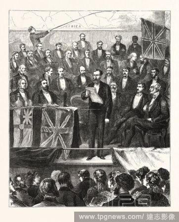
Editorial AFRICAN EXPLORATION : LIEUT. CAMERON READING AN ACCOUNT OF HIS ADVENTURES IN CENTRAL AFRICA BEFORE THE ROYAL GEOGRAPHICAL SOCIETY, AT ST. JAMES'S HALL, ON TUESDAY, APRIL 11TH., LONDON, ENGRAVING 1876, UK, britain, british, europe, united kingdom, great...
- 2022-12-24
- 1
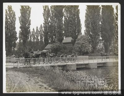
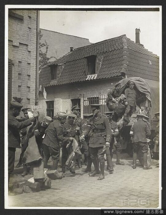
Editorial Field Artillery riding over a bridge [St Floris, France]. Men of the 13th Brigade, Royal Field Artillery under the command of Lieut-Col. Tyler, 30th July 1915. Record of the Indian Army in Europe during the First World War. 20th century, 30th July 1915...
- 2022-12-24
- 1
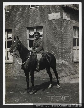
Editorial Lieut. Hitendra [Jitendra Narayan Bhup] of Kuch Behar on his horse 'Son of a Gun' [Le Sart, France]. A full-length portrait, in uniform, 24th July 1915. Record of the Indian Army in Europe during the First World War. 20th century, 24th July 1915. Gelat...
- 2022-12-24
- 1

Editorial Tasunka, (alias Plenty Horse[s]). The slayer of Lieut. Casey, near Pine Ridge, S.D., John C. H. Grabill was an american photographer. In 1886 he opened his first photographic studio.
- 2022-12-24
- 1
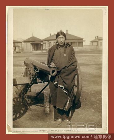
Editorial Tasunka, Ota (alias Plenty Horse[s]), the slayer of Lieut. Casey, near Pine Ridge, S.D., John C. H. Grabill was an american photographer. In 1886 he opened his first photographic studio.
- 2022-12-24
- 1

Editorial Tasunka, Ota (alias Plenty Horse[s]), the slayer of Lieut. Casey, near Pine Ridge, S.D., John C. H. Grabill was an american photographer. In 1886 he opened his first photographic studio.
- 2022-12-24
- 1

Editorial Ukraine-Cda-Latvia, Riga, Latvia - 17 Nov 2022
- 2022-11-19
- 1

Editorial Canada-Latvia, Riga, Latvia - 16 Nov 2022
- 2022-11-18
- 3
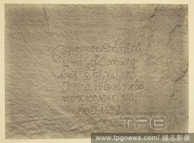
Editorial Historic Spanish Record of the Conquest, South Side of Inscription Rock, N.M. Geographical & Geological Explorations & Surveys West of the 100th Meridian. Expedition of 1873. -Lieut. Geo. M. Wheeler, Corps. of Engineers, Commanding. Timothy O'Sullivan;...
- 2022-07-21
- 1
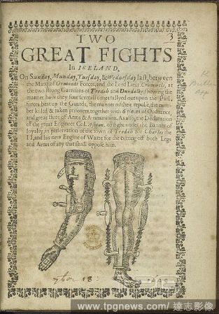
Editorial Woodcut on the subject of the battles at Tredah and Dundalk in Ireland in 1649 between the forces of the Marquis of Ormond and those of Oliver Cromwell. Two Great Fights in Ireland ... between the Marq: of Ormonds forces and the Lord Lieut. Cromwels at...
- 2022-07-21
- 1

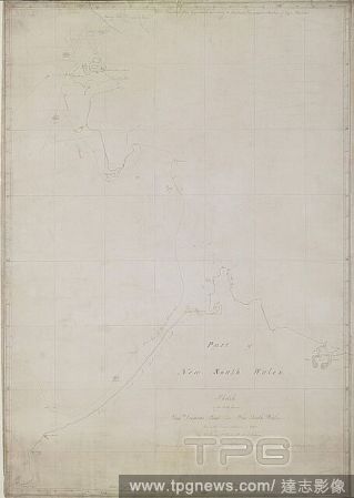
Editorial A chart of part of the south-eastern coast of the North Island of New Zealand, from Cape Runaway to Cape Kidnappers; drawn by Lieut. James Cook, shewing his track in 1769-1770. Charts, Plans, Views, and Drawings taken on board the Endeavour during Capt...
- 2022-04-25
- 1
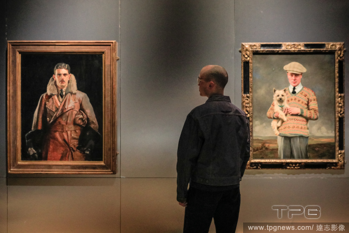
Editorial Fashioning Masculinities: The Art of Menswear photocall at the V&A, London, UK
- 2022-03-16
- 1

Editorial Illustration showing a girl guide. Girl Guides. A suggestion for character training for girls. (Pamphlet B. by Agnes Baden Powell and Lieut. Gen. Sir R. Baden-Powell.). London : Bishopsgate Press, [1909]. Source: 8306.aa.21.(3).
- 2022-01-18
- 1
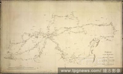
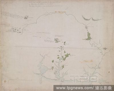
Editorial Survey of the marches of the British Army in the Mysore country during the campaigns of 1791 & 2 under Cornwallis. "Survey of the marches in the Mysore country," 1791, 1792, by Lieut. Robert Hyde Colebrooke.Mysore, India: Survey by Lieut. R. H. Colebro...
- 2022-01-18
- 1

Editorial The North Island of New Zealand, by Mr. Molineux, Master of the ' Endeavour':. CHARTS and maps made during voyages of discovery in the South Pacific Ocean by Samuel Wallis, commander of the "Dolphin," in 1767; Lieut. James Cook, commander of the "Endea...
- 2022-01-18
- 1
Editorial The Straits of Magellan, taken on board the "Dolphin," 1767; drawn by Richard Pickersgill. CHARTS and maps made during voyages of discovery in the South Pacific Ocean by Samuel Wallis, commander of the "Dolphin," in 1767; Lieut. James Cook, commander o...
- 2022-01-18
- 1
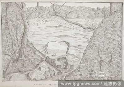
Editorial A view of the great natural arch at Tolaga; drawn by Lieut. James Cook. Charts, Plans, Views, and Drawings taken on board the Endeavour during Captain Cook's First Voyage, 1768-1771. 1769. Source: Add. 7085, No.22.
- 2022-01-18
- 1

Editorial New Zealand, by Mr. Molineux, master of the "Endeavour.". CHARTS and maps made during voyages of discovery in the South Pacific Ocean by Samuel Wallis, commander of the "Dolphin," in 1767; Lieut. James Cook, commander of the "Endeavour," in 1769 and 17...
- 2022-01-18
- 1
Editorial The North Island of New Zealand, by Mr. Molineux, Master of the ' Endeavour': Circ. 1770. CHARTS and maps made during voyages of discovery in the South Pacific Ocean by Samuel Wallis, commander of the "Dolphin," in 1767; Lieut. James Cook, commander of...
- 2022-01-18
- 1
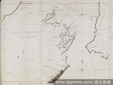
Editorial A chart of Cook's Straits, in New Zealand; drawn by Lieut. James Cook, on a large scale. Charts, Plans, Views, and Drawings taken on board the Endeavour during Captain Cook's First Voyage, 1768-1771. 1770. Ms. 2 f. 3 1/2 in. x 1 f. 7 1/2 in.; 70 x 50 c...
- 2022-01-18
- 1

Editorial Plan of the River Saint Lawrence from Montreal to the Parish of Berthier on the North side of the River, and Sorel on the South. [Halifax?] : by John Montresor Sub. Engineer & Lieut. Samuel Holland Capt. and Asting Engr., [between 1758 and 1763.]. Sour...
- 2022-01-18
- 1

Editorial A plan of the River Kennebeck as it was surveyed by order of the Government of Massachusets Bay in the year MDCCLXI from the falls above Halifax unto the place where the surveyor John Small was killed, from his field book, with the addition of lower pa...
- 2022-01-18
- 1
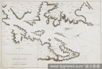
Editorial A plan of Queen Charlotte's Sound, on the southern side of Cook's Straits; drawn by Lieut. James Cook, on a scale of one mile to an inch. Charts, Plans, Views, and Drawings taken on board the Endeavour during Captain Cook's First Voyage, 1768-1771. 177...
- 2022-01-18
- 1

Editorial Plan of Yorktown, showing disposition of American, French and British forces. Drawn by Juliana 12th June 1782 & John Hoyman, Lieut. Inscribed as copy. PLANS of military operations, in North America, etc. 1716-1783. Source: Add. 15535.
- 2022-01-18
- 2
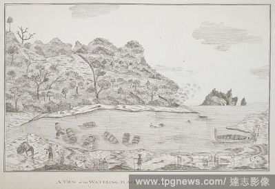
Editorial A view of the watering-place at Tolaga; drawn by Lieut. James Cook. Charts, Plans, Views, and Drawings taken on board the Endeavour during Captain Cook's First Voyage, 1768-1771. 1769. Ms. 1 f. 3 in. x 9 1/2 in.; 38 x 24 cm. Source: Add. 7085, No.21.
- 2022-01-18
- 1
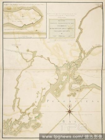
Editorial A plan of Massachusetts Bay and part of the River Penobscot. MAY 23. 1759. PROVINCE MASSACHUSETTS BAY PENOBSCOT DOMINIONS OF GREAT BRITAIN POSSESSION CONFIRM'D BY THOS. POWNALL GOVR. [Place of production not identified] : [by --- Jones, Capt. North, of...
- 2022-01-18
- 1

Editorial Plan of that part of Canada and the River St. Lawrence, which lies between the Coteau des Cedres (the uppermost settlements of Canada) and the Island of St. Therese... [Quebec?] : Capt. Holland of the Royal American Regiment ... Lieut. Montresor Engine...
- 2022-01-18
- 2

Editorial A chart of the north west coast of America and the north east coast of Asia. Chart of the N. W. Coast of America and the N. E. Coast of Asia explored in the years 1778 and 1779. Prepared by Lieut. H. Roberts, under the immediate inspection of Capt. Coo...
- 2022-01-18
- 1
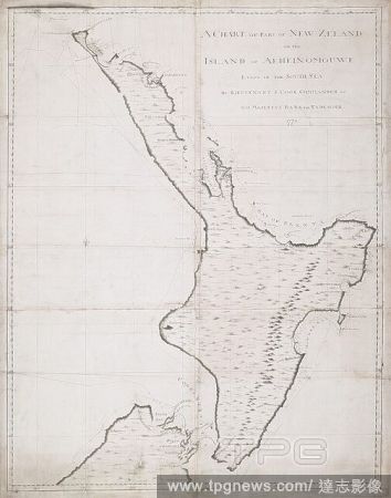
Editorial The Middle and North lslands of New Zealand, by James Cook; 1770. A chart of part of New Zealand or the island of Aeheinomouwe lying in the south sea by Lieutenant J.Cook commander of his Majesty's Bark the Endeavour. CHARTS and maps made during voyage...
- 2022-01-18
- 1
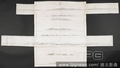
Editorial Various views of headlands on the coasts of New Zealand; drawn by Lieut. James Cook, in his first voyage. Charts, Plans, Views, and Drawings taken on board the Endeavour during Captain Cook's First Voyage, 1768-1771. ca. 1769-1770. Source: Add. 7085, N...
- 2022-01-18
- 1

Editorial A new plan of the Island of Grenada . A New Plan of the Island of Grenada from the original French Survey of M. Pinel. Taken in 1763 by order of government, and now published with the addition of English names, alterations of property and other improve...
- 2022-01-18
- 1

Editorial A chart of the peninsula of Nova Scotia. A CHART OF THE PENINSULA OF NOVA SCOTIA / done by order of His Excellency CHS. LAWRENCE Esqr. Lieut. Govr. & Commr. in Chief of his Majesty's Province of NOVA SCOTIA from many actual Surveys; and the whole corre...
- 2022-01-18
- 1
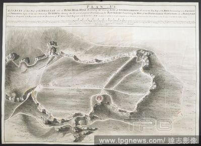
Editorial A survey of part of Gibraltar called the Windmill Hill. PLAN No: 3. A SURVEY of that Part of GIBRALTAR called the WIND-MILL-HILL Exhibiting the running LINE of ENTRENCHMENTS all round the Top Edge of the ROCK Commanding in an EMINENT and POWERFUL degre...
- 2022-01-18
- 1
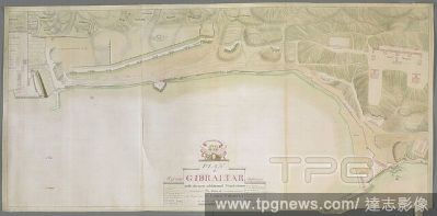
Editorial A plan of Gibraltar. PLAN of GIBRALTAR : with the new additional Work's done By Order of The Right Honble: the LORD TYRAWLY are mark'd with Red Letter. [Gibraltar] : Lieut: Geo: Massey, of the 53d. Regt: Delineavit, September 1758. Source: Maps K.Top.7...
- 2022-01-18
- 1
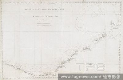
Editorial A chart of part of the sea coast of New South Wales, on the east coast of New Holland, from Point Hickes to Smoaky Cape; drawn by Lieut. James Cook, 1770. Charts, Plans, Views, and Drawings taken on board the Endeavour during Captain Cook's First Voyag...
- 2022-01-18
- 1
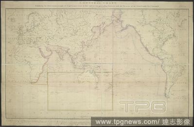
Editorial A general chart exhibiting the discoveries made by Capt. James Cook in this and his two preceeding voyages, with the Tracks of the ships under his command. A General Chart exhibiting the discoveries made by Capt? J. Cook in this and his two preceedin...
- 2022-01-18
- 1
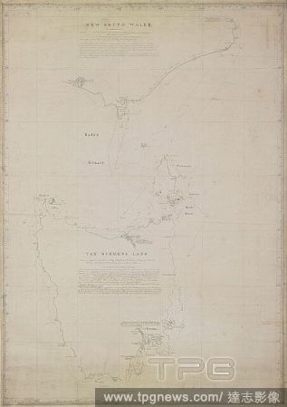
Editorial Part of New South Wales, Bass's Straits, and Van Diemens Land, by Matthew Flinders; 1798, 1799. CHARTS and maps made during voyages of discovery in the South Pacific Ocean by Samuel Wallis, commander of the "Dolphin," in 1767; Lieut. James Cook, comman...
- 2022-01-18
- 1
Editorial A chart of part of the sea coast of New South Wales, on the east coast of New Holland, from Cape Tribulation to Endeavour Straits; drawn by Lieut. James Cook, 1770. Charts, Plans, Views, and Drawings taken on board the Endeavour during Captain Cook's F...
- 2022-01-18
- 1
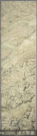
Editorial Map of post Jacobean Scotland in 1755, 10 years after the Battle of Culloden. The land of Culloden and Inverness. A very large and highly finished colored military survey of the kingdom of Scotland, exclusive of the islands, undertaken by order of Will...
- 2022-01-18
- 1
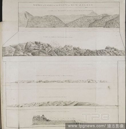
Editorial Various views of headlands on the coasts of New Zealand; drawn by Lieut. James Cook, in his first voyage. Charts, Plans, Views, and Drawings taken on board the Endeavour during Captain Cook's First Voyage, 1768-1771. ca. 1769-1770. Source: Add. 7085, N...
- 2022-01-18
- 1
Editorial Survey of Botany and Broken Bays and Port Jackson, in New South Wales, by Captain J[ohn] H[unter]. CHARTS and maps made during voyages of discovery in the South Pacific Ocean by Samuel Wallis, commander of the "Dolphin," in 1767; Lieut. James Cook, com...
- 2022-01-18
- 1
Editorial The parts between New South Wales and Van Diemen's Land, seen in the "Francis" schooner in 1798 by Matthew Flinders. CHARTS and maps made during voyages of discovery in the South Pacific Ocean by Samuel Wallis, commander of the "Dolphin," in 1767; Lieu...
- 2022-01-18
- 1
Editorial A chart of part of the north-eastern coast of the North Island of New Zealand, from the Cavalle Isles to the river Thames; drawn by Lieut. James Cook, shewing his track in 1769. Charts, Plans, Views, and Drawings taken on board the Endeavour during Cap...
- 2022-01-18
- 1
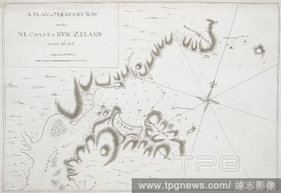
Editorial A plan of Mercury Bay, on the N.E. coast of New Zealand; drawn by Lieut. James Cook, on a scale of one inch to a mile. Charts, Plans, Views, and Drawings taken on board the Endeavour during Captain Cook's First Voyage, 1768-1771. 1769. Ms. 1 f. 4 1/2 i...
- 2022-01-18
- 1
Editorial Various views of headlands on the coasts of New Zealand; drawn by Lieut. James Cook, in his first voyage. Charts, Plans, Views, and Drawings taken on board the Endeavour during Captain Cook's First Voyage, 1768-1771. ca. 1769-1770. Source: Add. 7085, N...
- 2022-01-18
- 1
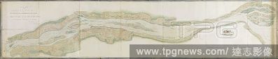
Editorial A plan of the St. Lawrence River from Montreal to Berthier on the North, and to Sorel on the South side of the River. A PLAN of the RIVER ST. LAURENCE from MONTREAL TO BERTHIER ON THE NORTH and to SOREL ON THE SOUTH SIDE OF THE RIVER; being part OF A S...
- 2022-01-18
- 1

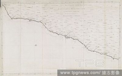
Editorial A chart of part of the sea coast of New South Wales, on the east coast of New Holland, from Smoaky Cape to Cape Townsend; drawn by Lieut. James Cook, 1770. Charts, Plans, Views, and Drawings taken on board the Endeavour during Captain Cook's First Voya...
- 2022-01-18
- 1
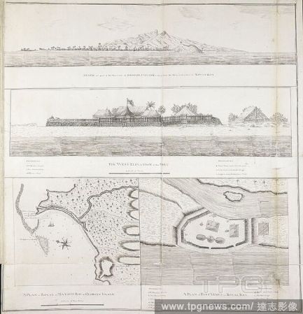
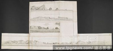
Editorial "A plan of Royal or Matavie Bay, in George's Island," or Otaheite, on a scale of 5 inches to a mile; with a view of the west side of the island, and a west elevation and plan of Fort Venus, in Royal Bay; drawn by Lieut. James Cook in his first voyage. ...
- 2022-01-18
- 1
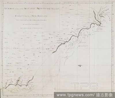
Editorial A chart of the sea coast of New South Wales, on the east coast of New Holland; drawn by Lieut. James Cook, who discovered and explored this coast in 1770. Charts, Plans, Views, and Drawings taken on board the Endeavour during Captain Cook's First Voyag...
- 2022-01-18
- 1

Editorial A plan of the City and Fortress of Louisbourg. Plan of the City and Fortress of LOUISBOURG Surrendered to his Britanick Majesty by Capitulation the 17 June 1745. to Lieut. Genl. Pepperel and Commodore Warren after 55 Days Blockade and 42 days open Tren...
- 2022-01-18
- 1
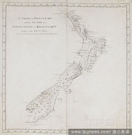
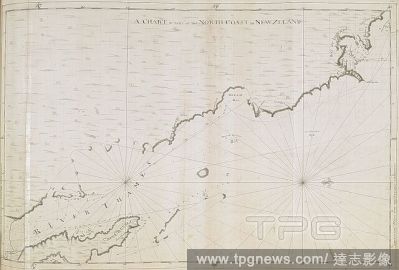
Editorial A general chart of New Zealand; drawn by Lieut. James Cook, shewing his track in 1769-1770. Charts, Plans, Views, and Drawings taken on board the Endeavour during Captain Cook's First Voyage, 1768-1771. 1769-1770. Ms. 1 f. 7 1/2 in. x 1 f. 7 1/2 in.; 5...
- 2022-01-18
- 1
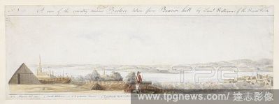
Editorial A view from Boston looking south, with a British soldier holding a bayonet standing by a cannon in a battery on top of Beacon Hill in the foreground. Boston rooftops can be seen beyond the palisade with Castle William on the left, Dorchester Point and ...
- 2022-01-18
- 1

Editorial A plan of King George's Island, or Otaheite; drawn by Lieut. James Cook in his first voyage, 1769, on a scale of one mile to an inch. . Charts, Plans, Views, and Drawings taken on board the Endeavour during Captain Cook's First Voyage, 1768-1771. 1769...
- 2022-01-18
- 1
Editorial A plan of part of Canada and the St. Lawrence River which lies between Dechambeaux and Pointe du Lac. The map includes four inset plans; a continuation of the Chaudière River at upper left, two further continuations at lower right, and also an inset p...
- 2022-01-18
- 2

Editorial A map of Niagara River May 1760'. Part of Lake Erie. . 'A map of Niagara River May 1760 Geo. Demler Lieut 60th Regimt'. 1:63360. 'Scale of 8 miles' (= 8 inches). Map oriented with West at top. Amherst no. A 55. R.U.S.I. no. A 27.33A. Laid down in the m...
- 2022-01-18
- 1

Editorial Various views of lands on the east coast of New South Wales; drawn by Lieut. James Cook, 1770. Charts, Plans, Views, and Drawings taken on board the Endeavour during Captain Cook's First Voyage, 1768-1771. 1770. Source: Add. 7085, No.36.
- 2022-01-18
- 1
Editorial Map of post Jacobean Scotland in 1755, 10 years after the Battle of Culloden. The land of Culloden and Inverness. The Roy Map of Scotland. A very large and highly finished colored military survey of the kingdom of Scotland, exclusive of the islands, un...
- 2022-01-18
- 1
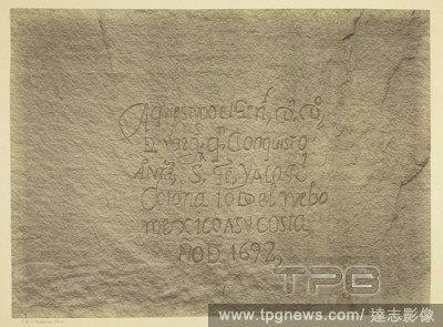
Editorial Historic Spanish Record of the Conquest, South Side of Inscription Rock, N.M. Geographical & Geological Explorations & Surveys West of the 100th Meridian. Expedition of 1873. -Lieut. Geo. M. Wheeler, Corps. of Engineers, Commanding. Timothy O'Sullivan;...
- 2021-10-09
- 1

Editorial Black Ca?on, Colorado River, looking below near Camp 7. Explorations in Nevada and Arizona, Expedition of 1871. Lieut. Geo. M. Wheeler, Com'd'g. Timothy O'Sullivan; American, born Ireland, 1840-1882. Date: 1871. Dimensions: 20.2 x 27.5 cm (image/paper)...
- 2021-10-09
- 1

Editorial Walter Cole's refined comic concert party, Brixton Hall, London. Assisted by Mr. Arthur W. Rigby vocalist, comedian, and mimic … Miss Katie Nanton … Mr. Walter Passmore, the well-known eccentric vocal comedian and mimic. Madame Sesor's Little Black...
- 2021-10-09
- 1
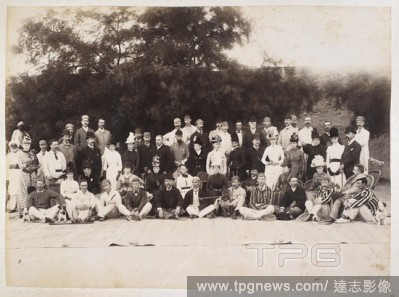
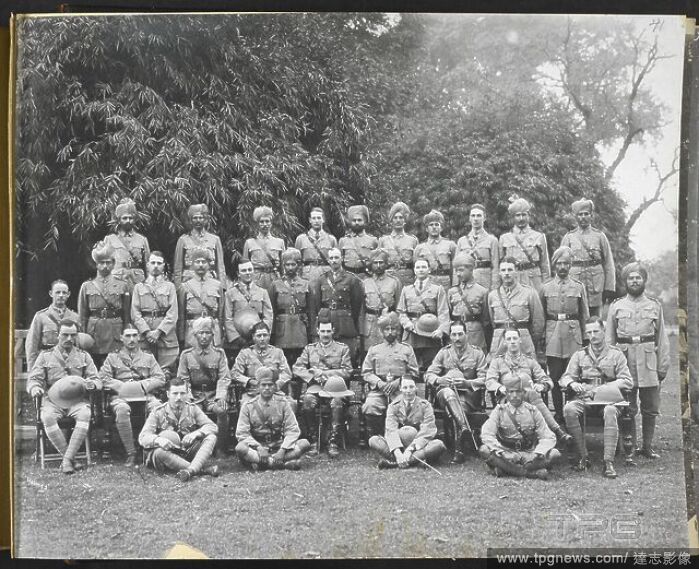
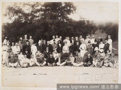
Editorial A European group, Hyderabad. This is most likely Hyderabad in Sindh, not the Deccan. Lieut-Colonel Reilly is sitting in a rattan chair right of centre . 1889. Photograph. Source: Photo 639/3(55).
- 2021-10-09
- 1
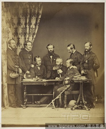
Editorial Group portrait of European army officers. Group is sitting round a table. Named in an accompanying manuscript list as: '[From left] 1. Major Holmes, Ass. Adj. Genl of Army; 2. Lieut Burne, Military Secretary; 3. Lt Col Hatch, Judge Advocate General of ...
- 2021-10-09
- 1
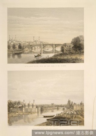
Editorial No.23: Iron bridge, from the left bank of the Goomtre. No.24: View from the Iron Bridge. . General views and special points of interest of the city of Lucknow / from drawings made on the spot by Lieut. Col. D.S. Dodgson, A.A.G. with descriptive notices...
- 2021-10-09
- 1
 Loading