
filter
-
Brand
- By Category
- Direction
- Date Range
61Events
Pictures
Events

Editorial NAB AFLW Season - Port Adelaide v Carlton - Alberton Oval
- 2024-09-29
- 1

Editorial 17th annual Diesel Gala and Beer Festival
- 2024-05-11
- 19

Editorial 17th annual Diesel Gala and Beer Festival, Swanage, Dorset, UK - 10 May 2024
- 2024-05-10
- 78

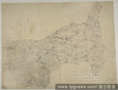
Editorial the North-South Geographical Demarcation Park Restoration and Renovation In Huai'an
- 2024-03-31
- 17

Editorial TRV-UST-BLUE-ORIGIN-ROCKET-SIMULATOR-OS
- 2023-12-11
- 1
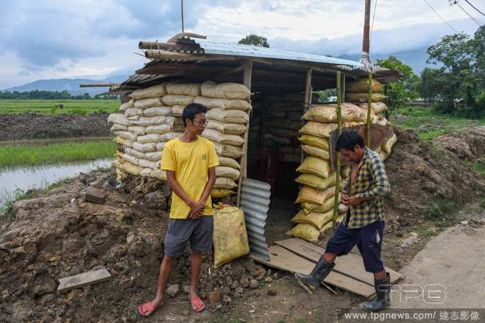
Editorial Men in Manipur villages picked up arms in Churachandpur - 11 Aug 2023
- 2023-08-20
- 3

Editorial Tribal youths take up arms in Churachandpur, India
- 2023-08-02
- 2

Editorial Ethnic violence and internal displacement in north-east Indian state of Manipur
- 2023-08-01
- 4

Editorial Iran-Aras Unesco Global Geopark, Julfa - 21 Jun 2023
- 2023-06-29
- 120

Editorial Anti ULEZ protest, Trafalgar Square, London, UK - 28 Jan 2023
- 2023-01-30
- 21

Editorial Thousands cross Hong Kong-China border as Covid restrictions end - 08 Jan 2023
- 2023-01-09
- 30
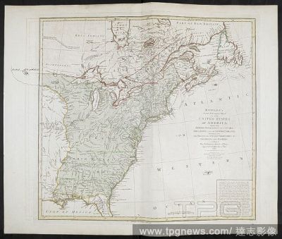
Editorial North America: Bowles' engraved map of the United States 1783, with a continuation of the boundary line in MS. . PLANS of military operations, in North America, etc. 1716-1783. Source: Add. 15535.
- 2022-12-24
- 1

Editorial Bentley Unveil Limited Edition Luxury Hybrid Bentayga Odyssean
- 2022-11-10
- 9

Editorial North Korea fired three short range ballistic missiles in Seoul, South Korea - 2 Nov 2022
- 2022-11-02
- 12

Editorial Australia vs England - T20 World Cup - Super 12 - Melbourne Cricket Ground
- 2022-10-28
- 1
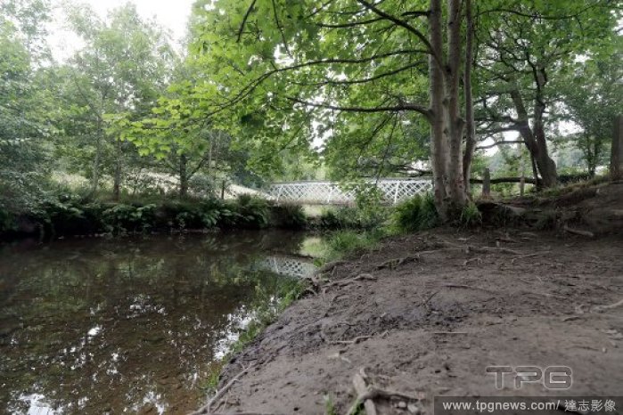
Editorial Mag Brook, Huddersfield
- 2022-07-29
- 3
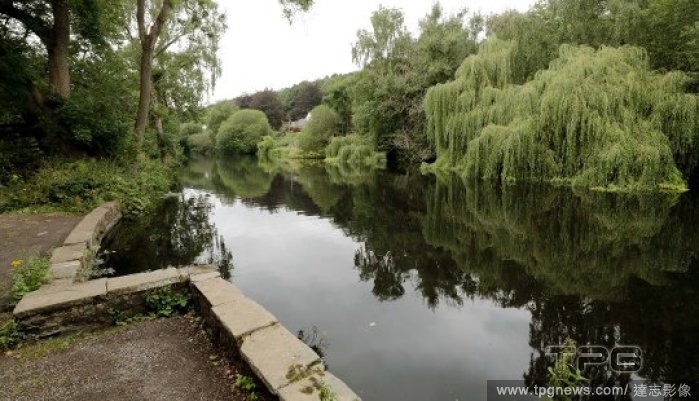
Editorial Mag Brook, Huddersfield
- 2022-07-29
- 2

Editorial Lebanon: Naqoura border with Israel
- 2022-06-27
- 9

Editorial North America: Bowles' engraved map of the United States 1783, with a continuation of the boundary line in MS. . PLANS of military operations, in North America, etc. 1716-1783. Source: Add. 15535.
- 2022-01-18
- 1
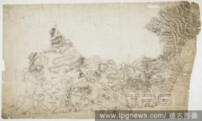
Editorial Map of Hampstead. The individual settlements that make up this area of London are shown by red blocks, with boundary lines indicating the fields separating them. Shading and soft interlining indicate relief, neatly illustrated at Primrose Hill, the su...
- 2021-10-09
- 1

Editorial Upper part of a double herm. From the two heads the rear heads merge with a boundary line. Of the two male figures there is a young and beardless and the other parent and with beard., Herme, marble, 24 cm, imperial time 0.
- 2021-02-20
- 1
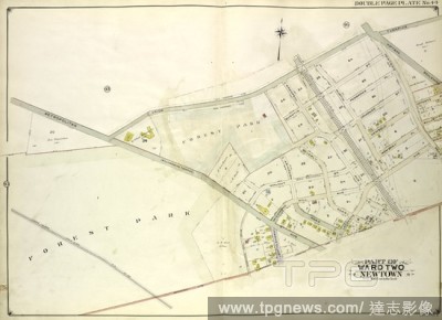
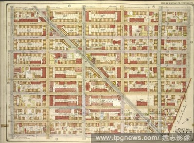
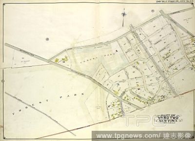
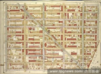
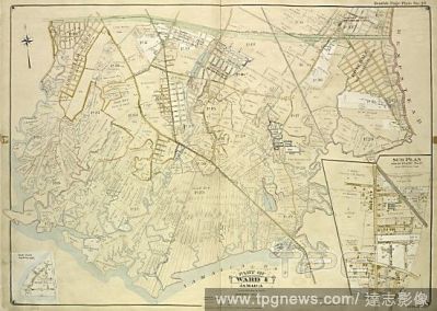
Editorial Queens, Vol. 2, Double Page Plate No. 44; Part of Ward Two Newtown; Map bounded by Union Turnpike, Hoffman Boulevard, Lefferts Ave., Muller Ave.; Including Augustin Ave, Newtown Road, Boundary line between Jamaica and Newtown, Long Island R.
- 2020-12-02
- 1

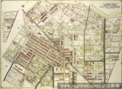
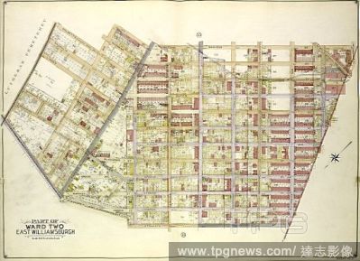
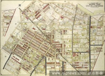
Editorial Queens, Vol. 2, Double Page Plate No. 34; Part of Ward Two East Williamsburgh; Map bounded by Palmetto St., Prospect Ave., Ivy St., Forest Ave., Ptnan Ave., Woodard Ave., Madison St., Myrtle Ave.; Including Boundary Line between borough of Qu.
- 2020-12-02
- 1

Editorial Brooklyn, Vol. 3, Double Page Plate No. 28; Part of Ward 28, Section 11; Map bounded by Stanhope St., St.Nicholas Ave., Boundary Line Borough of Brooklyn and Queens; Including Palmetto St., Central Ave.
- 2020-12-02
- 2

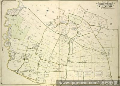
Editorial Queens, Vol. 3, Double Page Plate No. 19; Part of ward Three Flushing; Map bounded by Strongs Causeway Ireland, Mill Road, North Hempstead Turnpike, Crop Road, Union Ave., Hoffman Ave., Boundary Line of Flushing, Jamaica, Head of the Vlei.
- 2020-12-02
- 1
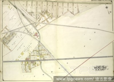
Editorial Queens, Vol. 2, Double Page Plate No. 43; Part of Ward Two Newtown; Map bounded by Metropolitan Ave. Williams Burg Turnpike, Ward Boundary line between Newtown and Jamaica, Myrtle Ave., Trotting Course Lane, Ocean View Ave.; Including Ma.
- 2020-12-02
- 2
Editorial Queens, Vol. 2, Double Page Plate No. 35; Part of Ward Two East Williamsburgh; Map bounded by Cooper Ave., Moffatt St., Irving Ave., Boundary line between borough of Queens and Brooklyn, Wyckof Ave., Madison St. Ivy St., Putnam Ave., Forest.
- 2020-12-02
- 1
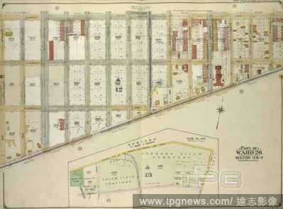
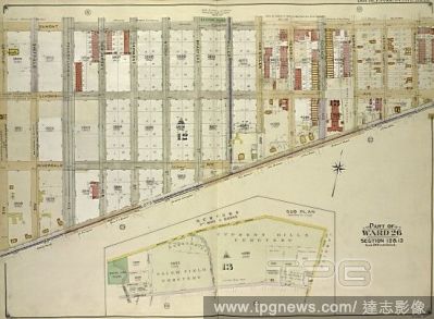
Editorial Brooklyn, Vol. 4, Double Page Plate No. 10; Part of Ward 26; Sections 12 & 13; Map bounded by Dumont Ave., Warwick St., New Lots Ave., Georgia Ave.; Sub Plan; Map bounded by Boundary Line of the Borough of Brooklyn and Queens, Elderts Lane;.
- 2020-12-02
- 1
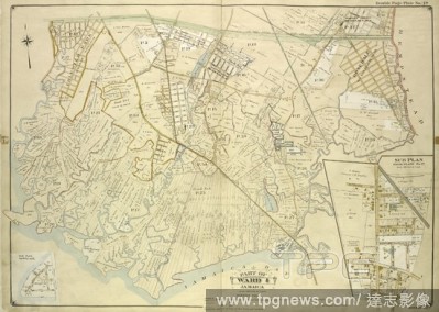
Editorial Queens, Vol. 1, Double Page Plate No. 19; Part Of Ward 4; Jamaica; Map bounded by Conduit Long Island R.R., Boundary Line Of The City of New York; Including Hook Canal Creek, Jamaica Bay, Dead or Salt Creek.; Sub Plan From Plate No. 17 Map bou.
- 2020-12-02
- 1
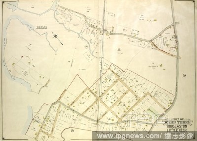
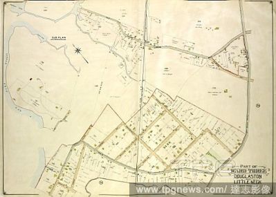
Editorial Queens, Vol. 3, Double Page Plate No. 21; Part of ward Three Sub Plan; Map bounded by Little Neck Bay, Odalls Cove; Including Bay St., Allen St.; Part of ward Three Douglaston and Little Neck; Map bounded by Boundary Line of City of New York a.
- 2020-12-02
- 1

Editorial COVID-19: Drive-In Concert in Bali
- 2020-08-18
- 1

Editorial Drive-In Concert in Bali, Indonesia
- 2020-08-18
- 24

Editorial Seattle Police Clear CHOP Zone
- 2020-07-05
- 7
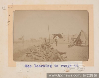
Editorial Photograph - 'Men Learning to Rough It', Egypt, Trooper G.S. Millar, World War I, 1914-1915, One of 49 photographs in an album from World War I likely to have been taken by Troop (later Lieutenant) G.S. Millar depicting the Light Horse camp in Egypt, 1...
- 2019-11-18
- 1

Editorial The illustration shows Prince Selarasa on the far right, with two of his elder brothers paying their respects to a holy man. The sage's daughter, Ni Rumsari, had dreamt that three handsome men would come to visit. Behind her stands a female servant fr...
- 2019-07-16
- 1
Editorial Brooklyn, Vol. 3, Double Page Plate No. 28; Part of Ward 28, Section 11; Map bounded by Stanhope St., St.Nicholas Ave., Boundary Line Borough of Brooklyn and Queens; Including Palmetto St., Central Ave.
- 2019-07-09
- 1

Editorial Brooklyn, Vol. 4, Double Page Plate No. 10; Part of Ward 26; Sections 12 & 13; Map bounded by Dumont Ave., Warwick St., New Lots Ave., Georgia Ave.; Sub Plan; Map bounded by Boundary Line of the Borough of Brooklyn and Queens, Elderts Lane;.
- 2019-07-09
- 1

Editorial North America: Bowles' engraved map of the United States 1783, with a continuation of the boundary line in MS. . PLANS of military operations, in North America, etc. 1716-1783. Source: Add. 15535.
- 2018-12-06
- 1

Editorial The illustration shows Prince Selarasa on the far right, with two of his elder brothers paying their respects to a holy man. The sage's daughter, Ni Rumsari, had dreamt that three handsome men would come to visit. Behind her stands a female servant fr...
- 2018-12-06
- 1
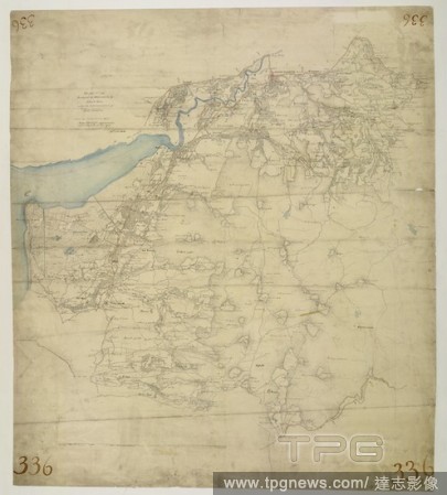
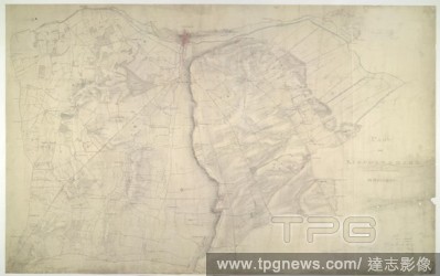
Editorial Feltwell St. Nicholas. The pecked red line following the course of the Little Ouse marks the county boundary of Norfolk and Cambridgeshire. Drawn on the left of the sheet, along the Ouse Valley, is a patchwork of arable land divided by straight water-f...
- 2018-12-06
- 1

Editorial Map of Hampstead. The individual settlements that make up this area of London are shown by red blocks, with boundary lines indicating the fields separating them. Shading and soft interlining indicate relief, neatly illustrated at Primrose Hill, the su...
- 2018-12-06
- 1
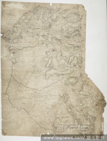
Editorial This drawing covers the boundary between the counties of Cardiganshire and Montgomeryshire. The border is marked as a red pecked line, following the course of the River Dovey for much of its length. Archaeological sites are noted in gothic script, an o...
- 2018-12-06
- 1
Editorial This plan covers an area of 82.625 square miles in Nottinghamshire and Lincolnshire. The county boundary is indicated by a red pecked line following the course of the River Trent down the right of the sheet. Land use is indicated by colours instead of ...
- 2018-12-06
- 1
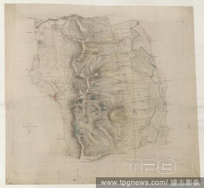
Editorial Welford. This drawing depicts the boundary of Leicestershire and Northamptonshire. The county border is indicated at top left by a pecked line following the course of the River Avon. Relative relief is depicted by brushwork interlining ('hachuring') an...
- 2018-12-06
- 1
Editorial This drawing shows the county boundary of Lincolnshire and Nottinghamshire as a red dotted line down the left of the sheet. The county town is depicted at the top of the plan on the north bank of the river Witham, set on the summit of the limestone rid...
- 2018-12-06
- 1
Editorial Queens, Vol. 2, Double Page Plate No. 44; Part of Ward Two Newtown; Map bounded by Union Turnpike, Hoffman Boulevard, Lefferts Ave., Muller Ave.; Including Augustin Ave, Newtown Road, Boundary line between Jamaica and Newtown, Long Island R.
- 2018-07-31
- 1
Editorial Queens, Vol. 2, Double Page Plate No. 34; Part of Ward Two East Williamsburgh; Map bounded by Palmetto St., Prospect Ave., Ivy St., Forest Ave., Ptnan Ave., Woodard Ave., Madison St., Myrtle Ave.; Including Boundary Line between borough of Qu.
- 2018-07-31
- 1
Editorial Brooklyn, Vol. 3, Double Page Plate No. 28; Part of Ward 28, Section 11; Map bounded by Stanhope St., St.Nicholas Ave., Boundary Line Borough of Brooklyn and Queens; Including Palmetto St., Central Ave.
- 2018-07-31
- 2
Editorial Queens, Vol. 3, Double Page Plate No. 19; Part of ward Three Flushing; Map bounded by Strongs Causeway Ireland, Mill Road, North Hempstead Turnpike, Crop Road, Union Ave., Hoffman Ave., Boundary Line of Flushing, Jamaica, Head of the Vlei.
- 2018-07-31
- 1

Editorial Queens, Vol. 2, Double Page Plate No. 43; Part of Ward Two Newtown; Map bounded by Metropolitan Ave. Williams Burg Turnpike, Ward Boundary line between Newtown and Jamaica, Myrtle Ave., Trotting Course Lane, Ocean View Ave.; Including Ma.
- 2018-07-31
- 2
Editorial Queens, Vol. 2, Double Page Plate No. 35; Part of Ward Two East Williamsburgh; Map bounded by Cooper Ave., Moffatt St., Irving Ave., Boundary line between borough of Queens and Brooklyn, Wyckof Ave., Madison St. Ivy St., Putnam Ave., Forest.
- 2018-07-31
- 1
Editorial Brooklyn, Vol. 4, Double Page Plate No. 10; Part of Ward 26; Sections 12 & 13; Map bounded by Dumont Ave., Warwick St., New Lots Ave., Georgia Ave.; Sub Plan; Map bounded by Boundary Line of the Borough of Brooklyn and Queens, Elderts Lane;.
- 2018-07-31
- 1
Editorial Queens, Vol. 1, Double Page Plate No. 19; Part Of Ward 4; Jamaica; Map bounded by Conduit Long Island R.R., Boundary Line Of The City of New York; Including Hook Canal Creek, Jamaica Bay, Dead or Salt Creek.; Sub Plan From Plate No. 17 Map bou.
- 2018-07-31
- 1
Editorial Queens, Vol. 3, Double Page Plate No. 21; Part of ward Three Sub Plan; Map bounded by Little Neck Bay, Odalls Cove; Including Bay St., Allen St.; Part of ward Three Douglaston and Little Neck; Map bounded by Boundary Line of City of New York a.
- 2018-07-31
- 1
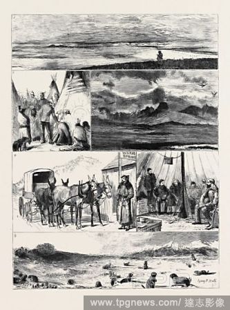
Editorial IN THE GREAT NORTH-WEST WITH THE MARQUIS OF LORNE, CROSSING THE BOUNDARY LINE: 1. Rolling Prairie: An Attempt by Dr. Macgregor to Describe the Infinite; 2. A Visit to the Blackfeet Lodges, Fort McLeod; 3. "Chief" Mountain, on the Boundary Line Between ...
- 2018-07-24
- 1

Editorial THE BOUNDARY LINE BETWEEN THE UNITED STATES AND CANADA.
- 2018-07-24
- 1

Editorial THE SAN JUAN BOUNDARY QUESTION: BOUNDARY LINE BETWEEN BRITISH COLUMBIA AND THE UNITED STATES.
- 2018-07-24
- 1
 Loading