
filter
-
Brand
- By Category
- Direction
- Date Range
53Events
Pictures
Events
Editorial
- 2023-11-01
- 1

Editorial Montpellier: Tribute to French teachers Samuel Paty and Dominique Bernard
- 2023-10-17
- 30
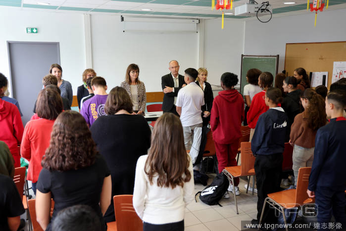
Editorial Montpellier: Ceremony for slain French teachers Samuel Paty and Dominique Bernard
- 2023-10-16
- 6
Editorial Montpellier: Ceremony for slain French teachers Samuel Paty and Dominique Bernard
- 2023-06-14
- 1
Editorial Montpellier: Ceremony for slain French teachers Samuel Paty and Dominique Bernard
- 2023-03-21
- 3
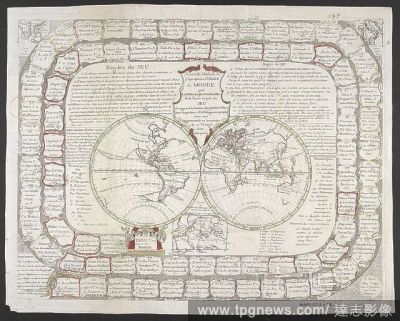
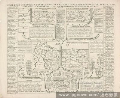
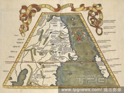
Editorial A map of the world in two hemispheres. . Nouvelle methode de geographie ou voiage du monde par les villes les plus considerables de la terre ou par un jeu on apprend la situation des pai?s & de villes, leur dependance & la religion des peuples avec un...
- 2022-01-18
- 1
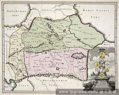
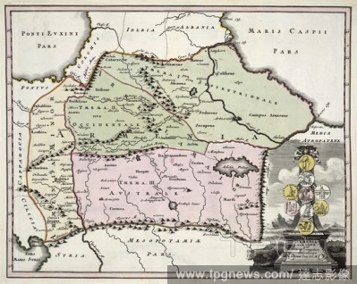
Editorial Armenia. J.D. K?hler's ... Schul- und Reisen-Atlas aller zu. Nuremberg, 1718. Map of Armenia. Image taken from J.D. K?hler's Schul- und Reisen-Atlas aller zu Erlernung der alten, mittlern und neuen Geographie, dienlichen Universal- und Particular-Ch...
- 2022-01-18
- 1

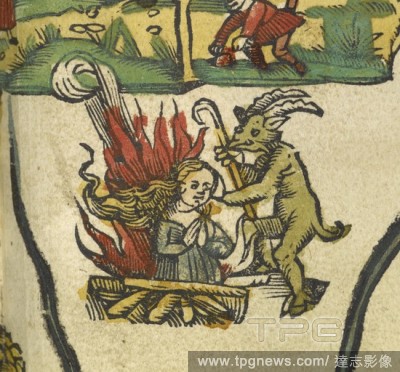
Editorial Ancient depiction of a suttee. A horned figure standing by a woman burning on a pyre. . Claudii Ptolemaei ... opus Geographie? [translated by J. Angelius] ... [Strassburg] : Joannes Grieninger civis Argentoraten?, 1522. Source: Maps.C.1.d.11.
- 2020-12-04
- 1

Editorial Rassemblement devant la prefecture de Grenoble en hommage au professeur d histoire geographie Samuel Paty
- 2020-10-19
- 36
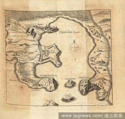
Editorial The Gulf of Spetie, Overview Il golfo della Spezia, S. 744, 1702, Schauplatz des Krieges in Italien, oder accurate Beschreibung der Lombardey: worinnen der Hertzogth?mer Meyland, Savoyen, Piemont, Montferrat, Parma, Modena und Mantua, auch derer Republ...
- 2020-01-15
- 1
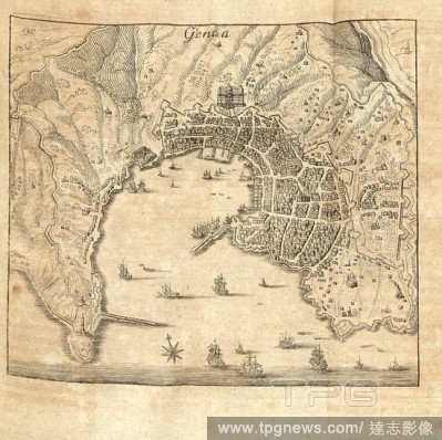
Editorial Genoa, Plan Genoa, p. 747, 1702, Schauplatz des Krieges in Italien, oder accurate Beschreibung der Lombardey: worinnen der Hertzogth?mer Meyland, Savoyen, Piemont, Montferrat, Parma, Modena und Mantua, auch derer Republiquen Venedig, Genua und Lucca, i...
- 2020-01-15
- 1
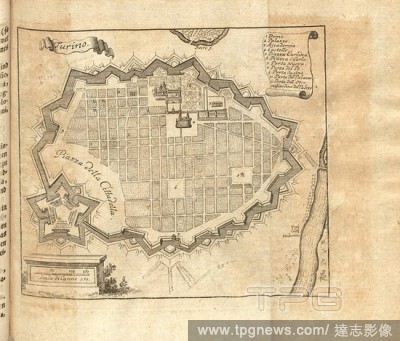
Editorial Turin, Plan Turin, p. 145, 1702, Schauplatz des Krieges in Italien, oder accurate Beschreibung der Lombardey: worinnen der Hertzogth?mer Meyland, Savoyen, Piemont, Montferrat, Parma, Modena und Mantua, auch derer Republiquen Venedig, Genua und Lucca, i...
- 2020-01-15
- 1
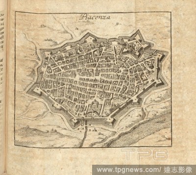
Editorial Piacenza, Plan Piacenza, p. 520, 1702, Schauplatz des Krieges in Italien, oder accurate Beschreibung der Lombardey: worinnen der Hertzogth?mer Meyland, Savoyen, Piemont, Montferrat, Parma, Modena und Mantua, auch derer Republiquen Venedig, Genua und Lu...
- 2020-01-15
- 1
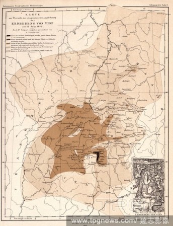
Editorial Map showing the geographical extent of the Visp earthquake on 25 July 1855, Map on the extent of damage caused by the earthquake at Visp, signed: signed by A. Petermann; Lith., v, C. Hellfarth, Plate 7, ed. 1856, Petermann, August (gez.); Lith. Anst. v...
- 2020-01-15
- 1
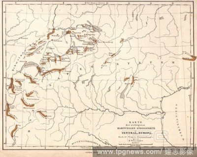
Editorial Map of the most important habitual shock areas in Central Europe, Map on earthquakes in Switzerland and northern Italy, signed: signed by A. Peterman, pl. 6, ed. 1856, Petermann, August (gez.), 1856, August Petermann: Mittheilungen aus Justus Perthes? ...
- 2020-01-15
- 1
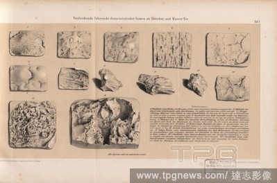
Editorial Comparative overview of characteristic forms of glacier and water ice, Comparison of glacial ice with water ice, Signed: After the original castings in plaster cast and lith., v, G. B?hmer; Gedr, b, Winckelmann u., Sons, Plate 1, B?hmer, G. (gez. u. li...
- 2020-01-15
- 1
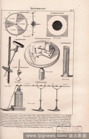
Editorial instruments, Cyanometer, Diaphanometer, Pyrheliometer, Prismatic Porometer, Eudiometer, Anthracometer, Signed: Lith., H. Drosse, Plate X., Drosse, H. (lith.), 1850, Hermann Schlagintweit; Adolph Schlagintweit: Untersuchungen ?ber die physicalische Geog...
- 2020-01-15
- 1

Editorial Politische Geographie : Ratzel, Friedrich, 1844-1904.
- 2019-12-18
- 1
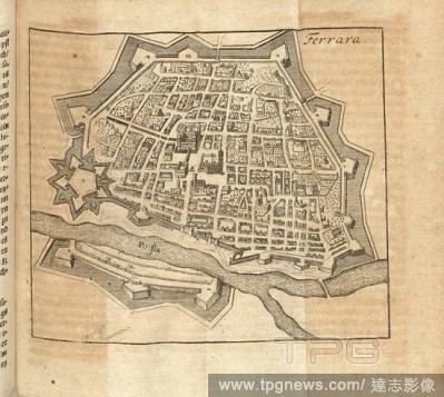
Editorial Ferrara, Plan Ferrara, p. 575, 1702, Schauplatz des Krieges in Italien, oder accurate Beschreibung der Lombardey: worinnen der Hertzogth?mer Meyland, Savoyen, Piemont, Montferrat, Parma, Modena und Mantua, auch derer Republiquen Venedig, Genua und Lucc...
- 2019-11-18
- 1
Editorial Cremona, Plan Cremona, p. 1026, 1702, Schauplatz des Krieges in Italien, oder accurate Beschreibung der Lombardey: worinnen der Hertzogth?mer Meyland, Savoyen, Piemont, Montferrat, Parma, Modena und Mantua, auch derer Republiquen Venedig, Genua und Luc...
- 2019-11-18
- 1

Editorial Venice, Plan Venice, p. 621, 1702, Schauplatz des Krieges in Italien, oder accurate Beschreibung der Lombardey: worinnen der Hertzogth?mer Meyland, Savoyen, Piemont, Montferrat, Parma, Modena und Mantua, auch derer Republiquen Venedig, Genua und Lucca,...
- 2019-11-18
- 1
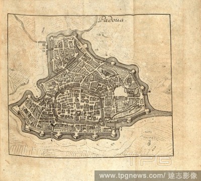
Editorial Padova, Plan Padua, p. 653, 1702, Schauplatz des Krieges in Italien, oder accurate Beschreibung der Lombardey: worinnen der Hertzogth?mer Meyland, Savoyen, Piemont, Montferrat, Parma, Modena und Mantua, auch derer Republiquen Venedig, Genua und Lucca, ...
- 2019-11-18
- 1
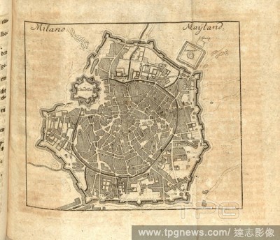
Editorial Milano, Mayland, Plan Milan, p. 397, 1702, Schauplatz des Krieges in Italien, oder accurate Beschreibung der Lombardey: worinnen der Hertzogth?mer Meyland, Savoyen, Piemont, Montferrat, Parma, Modena und Mantua, auch derer Republiquen Venedig, Genua un...
- 2019-11-18
- 1
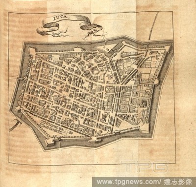
Editorial Luca, Plan Lucca, Date Appreciated, S. 804, 1702, Schauplatz des Krieges in Italien, oder accurate Beschreibung der Lombardey: worinnen der Hertzogth?mer Meyland, Savoyen, Piemont, Montferrat, Parma, Modena und Mantua, auch derer Republiquen Venedig, G...
- 2019-11-18
- 1

Editorial Villa Franca, Villefranche-sur-Mer, p. 202, 1702, Schauplatz des Krieges in Italien, oder accurate Beschreibung der Lombardey: worinnen der Hertzogth?mer Meyland, Savoyen, Piemont, Montferrat, Parma, Modena und Mantua, auch derer Republiquen Venedig, G...
- 2019-11-18
- 1
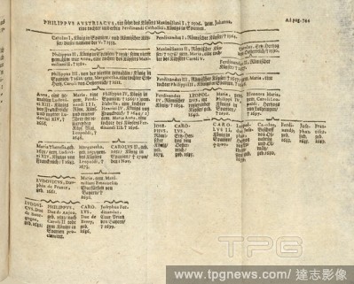
Editorial Pilippus Austriacus, Family tree Philipp I of Habsburg, S. 861, 1702, Schauplatz des Krieges in Italien, oder accurate Beschreibung der Lombardey: worinnen der Hertzogth?mer Meyland, Savoyen, Piemont, Montferrat, Parma, Modena und Mantua, auch derer Re...
- 2019-11-18
- 1

Editorial Ancient depiction of a suttee. A horned figure standing by a woman burning on a pyre. . Claudii Ptolemaei ... opus Geographie? [translated by J. Angelius] ... [Strassburg] : Joannes Grieninger civis Argentoraten?, 1522. Source: Maps.C.1.d.11.
- 2019-07-09
- 1

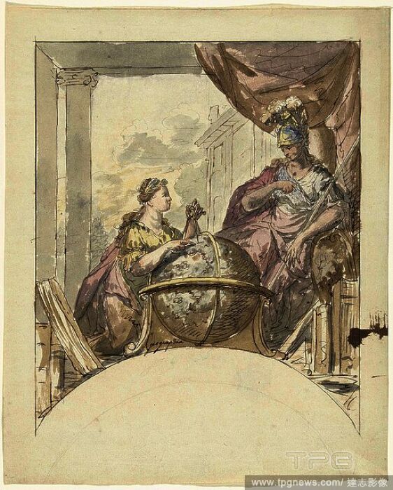
Editorial Geographie and Minerva. Draughtsman: Elias van Nijmegen. Dating: 1677 - 1755. Measurements: h 305 mm ? w 246 mm.
- 2019-01-25
- 1
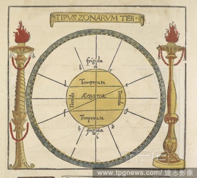
Editorial A 16th century climatic map/diagram of the world. Claudii Ptolemaei ... opus Geographie? [translated by J. Angelius] ... [Strassburg] : Joannes Grieninger civis Argentoraten?, 1522. Source: Maps.C.1.d.11.
- 2019-01-24
- 1
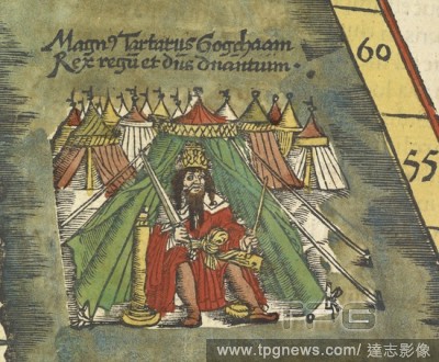
Editorial Ancient depiction of the Great Khan. Claudii Ptolemaei ... opus Geographie? [translated by J. Angelius] ... [Strassburg] : Joannes Grieninger civis Argentoraten?, 1522. Source: Maps.C.1.d.11.
- 2018-12-06
- 1

Editorial 16th century map showing east India. Claudii Ptolemaei ... opus Geographie? [translated by J. Angelius] ... [Strassburg] : Joannes Grieninger civis Argentoraten?, 1522. Source: Maps.C.1.d.11.
- 2018-12-06
- 1
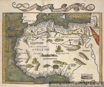
Editorial 16th century map showing northern Africa. Claudii Ptolemaei ... opus Geographie? [translated by J. Angelius] ... [Strassburg] : Joannes Grieninger civis Argentoraten?, 1522. Source: Maps.C.1.d.11.
- 2018-12-06
- 1

Editorial A 16th century climatic map/diagram of the world. Claudii Ptolemaei ... opus Geographie? [translated by J. Angelius] ... [Strassburg] : Joannes Grieninger civis Argentoraten?, 1522. Source: Maps.C.1.d.11.
- 2018-12-06
- 1
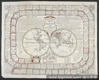
Editorial A map of the world in two hemispheres. . Nouvelle methode de geographie ou voiage du monde par les villes les plus considerables de la terre ou par un jeu on apprend la situation des pai?s & de villes, leur dependance & la religion des peuples avec un...
- 2018-12-06
- 1
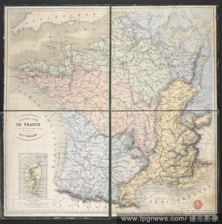
Editorial A map of France. Nouvelle carte de France, a l'usage de la geographie versifie?e de la France / par M. V[ict]or Guillon ; Imp[rime?e] Lemercier, Paris. Paris : A. Logerot, e?diteur, Quai des Augustins 55, [1862?]. Source: Maps.c.27.f.21. Language: F...
- 2018-12-06
- 1
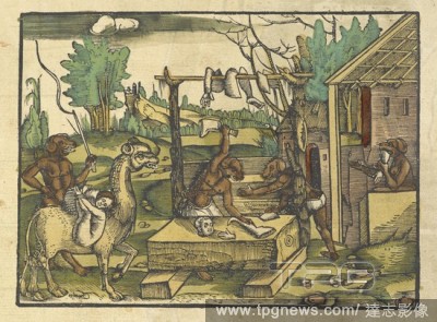
Editorial Asian dog headed cannibals. Claudii Ptolemaei ... opus Geographie? [translated by J. Angelius] ... [Strassburg] : Joannes Grieninger civis Argentoraten?, 1522. Source: Maps.C.1.d.11.
- 2018-12-06
- 1
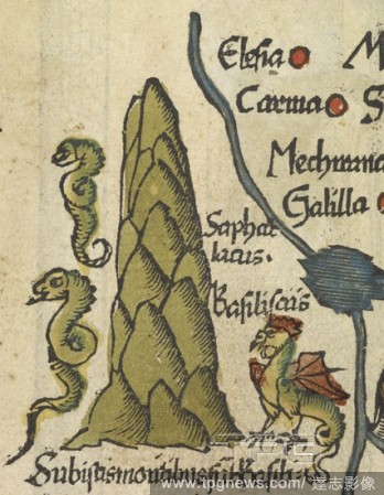
Editorial A basilisk and seahorses. Claudii Ptolemaei ... opus Geographie? [translated by J. Angelius] ... [Strassburg] : Joannes Grieninger civis Argentoraten?, 1522. Source: Maps.C.1.d.11.
- 2018-12-06
- 1

Editorial A map of Norwich. The Cosmographical Glasse, conteinyng the pleasant Principles of Cosmographie, Geographie, Hydrographie, or Nauigation. [With woodcuts, including a map of Norwich.]. Londini : In officina Ioan Daij, 1559. Source: G.6583. Language: Eng...
- 2018-12-06
- 1
Editorial 16th century map showing part of northern Asia. Claudii Ptolemaei ... opus Geographie? [translated by J. Angelius] ... [Strassburg] : Joannes Grieninger civis Argentoraten?, 1522. Source: Maps.C.1.d.11.
- 2018-12-06
- 1

Editorial 16th century map showing southern Africa. Claudii Ptolemaei ... opus Geographie? [translated by J. Angelius] ... [Strassburg] : Joannes Grieninger civis Argentoraten?, 1522. Source: Maps.C.1.d.11.
- 2018-12-06
- 1
Editorial Ancient depiction of a suttee. A horned figure standing by a woman burning on a pyre. . Claudii Ptolemaei ... opus Geographie? [translated by J. Angelius] ... [Strassburg] : Joannes Grieninger civis Argentoraten?, 1522. Source: Maps.C.1.d.11.
- 2018-12-06
- 1

Editorial Ancient depiction of cannibals. Claudii Ptolemaei ... opus Geographie? [translated by J. Angelius] ... [Strassburg] : Joannes Grieninger civis Argentoraten?, 1522. Source: Maps.C.1.d.11.
- 2018-12-06
- 1
Editorial Armenia. J.D. K?hler's ... Schul- und Reisen-Atlas aller zu. Nuremberg, 1718. Map of Armenia. Image taken from J.D. K?hler's Schul- und Reisen-Atlas aller zu Erlernung der alten, mittlern und neuen Geographie, dienlichen Universal- und Particular-Ch...
- 2018-12-06
- 1

Editorial Ancient depiction of a man. . Claudii Ptolemaei ... opus Geographie? [translated by J. Angelius] ... [Strassburg] : Joannes Grieninger civis Argentoraten?, 1522. Source: Maps.C.1.d.11.
- 2018-12-06
- 1
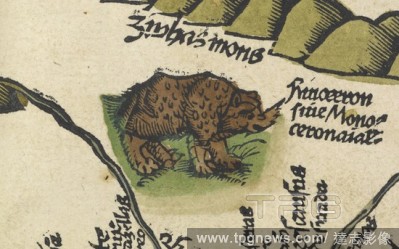
Editorial Ancient depiction of a rhinocerous. Claudii Ptolemaei ... opus Geographie? [translated by J. Angelius] ... [Strassburg] : Joannes Grieninger civis Argentoraten?, 1522. Source: Maps.C.1.d.11.
- 2018-12-06
- 1
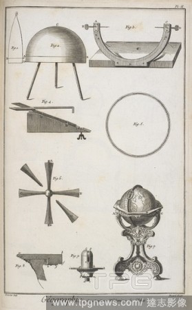
Editorial 'Geographie'. Various measuring instruments. Encylopaedie. 18th century. Source: BAR.034.1.(5).
- 2018-12-06
- 1
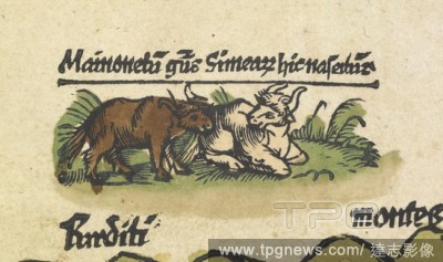
Editorial Two bulls. Claudii Ptolemaei ... opus Geographie? [translated by J. Angelius] ... [Strassburg] : Joannes Grieninger civis Argentoraten?, 1522. Source: Maps.C.1.d.11.
- 2018-12-06
- 1
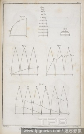
Editorial Geographie, construction geographie des globes. Diagrams of Measurements. Encyclope?die. 18th century. Source: BAR.034.1.(5) Plate 1.
- 2018-12-06
- 1

Editorial 16th century map showing part of India. Claudii Ptolemaei ... opus Geographie? [translated by J. Angelius] ... [Strassburg] : Joannes Grieninger civis Argentoraten?, 1522. Source: Maps.C.1.d.11.
- 2018-12-06
- 1
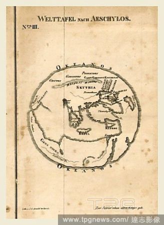
Editorial Aeschylos, Handbuch der alten Geographie, 19th century engraving.
- 2018-07-27
- 1

Editorial NAIPE DE BARAJA"GEOGRAPHIE"DISE?ADA PARA EL DELFIN 1698-SIG.E.R.2947.
- 2018-07-19
- 1
 Loading