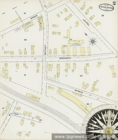
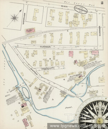
EditorialImage 2 of Sanborn Fire Insurance Map from Leominster, Worcester County, Massachusetts. Feb 1896. 11 Sheet(s), America, street map with a Nineteenth Century compass.
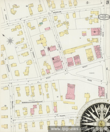
EditorialImage 4 of Sanborn Fire Insurance Map from Leominster, Worcester County, Massachusetts. Jan 1884. 7 Sheet(s), America, street map with a Nineteenth Century compass.
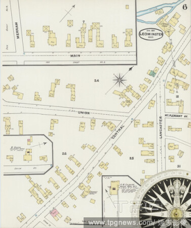
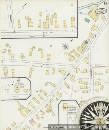
EditorialImage 6 of Sanborn Fire Insurance Map from Leominster, Worcester County, Massachusetts. Apr 1891. 10 Sheet(s), America, street map with a Nineteenth Century compass.
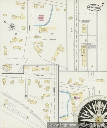
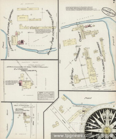
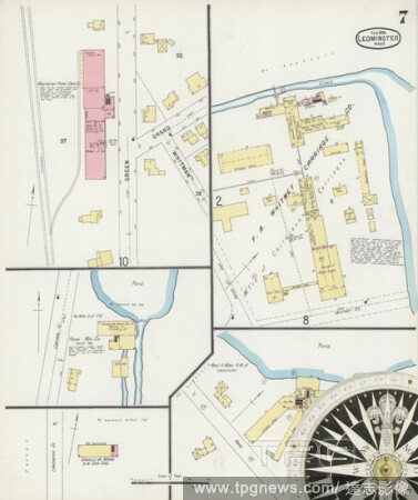
EditorialImage 7 of Sanborn Fire Insurance Map from Leominster, Worcester County, Massachusetts. Apr 1891. 10 Sheet(s), America, street map with a Nineteenth Century compass.
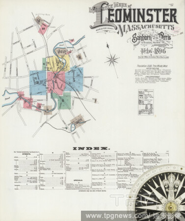
EditorialImage 1 of Sanborn Fire Insurance Map from Leominster, Worcester County, Massachusetts. Feb 1896. 11 Sheet(s), America, street map with a Nineteenth Century compass.
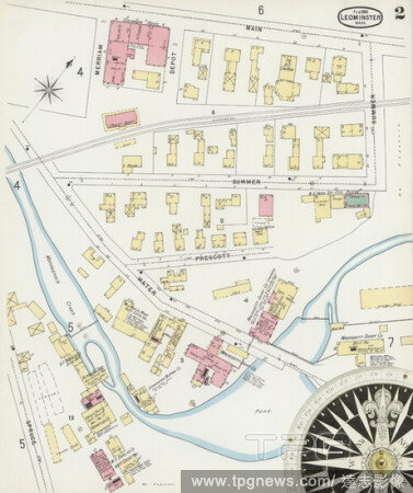
EditorialImage 2 of Sanborn Fire Insurance Map from Leominster, Worcester County, Massachusetts. Apr 1891. 10 Sheet(s), America, street map with a Nineteenth Century compass.
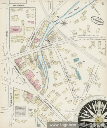
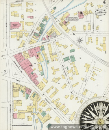
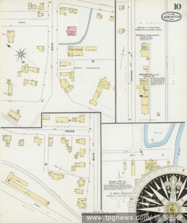
EditorialImage 4 of Sanborn Fire Insurance Map from Leominster, Worcester County, Massachusetts. Feb 1896. 11 Sheet(s), America, street map with a Nineteenth Century compass.
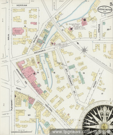
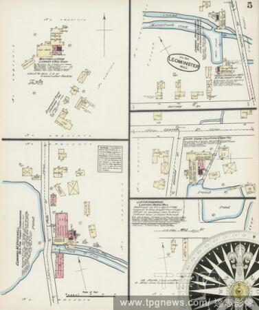
EditorialImage 5 of Sanborn Fire Insurance Map from Leominster, Worcester County, Massachusetts. Apr 1891. 10 Sheet(s), America, street map with a Nineteenth Century compass.
EditorialImage 6 of Sanborn Fire Insurance Map from Leominster, Worcester County, Massachusetts. Feb 1896. 11 Sheet(s), America, street map with a Nineteenth Century compass.
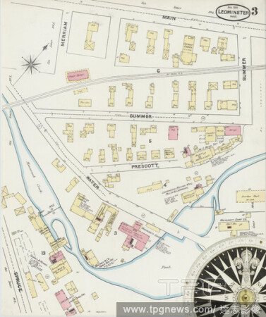
EditorialImage 3 of Sanborn Fire Insurance Map from Leominster, Worcester County, Massachusetts. Feb 1896. 11 Sheet(s), America, street map with a Nineteenth Century compass.
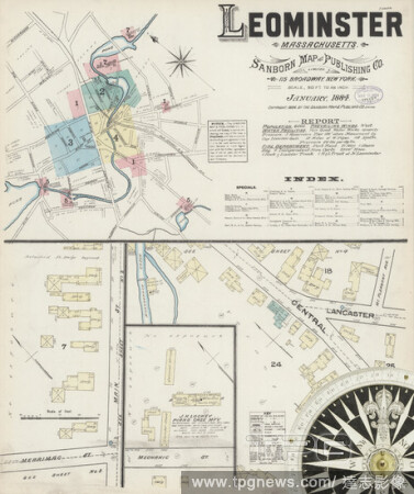
EditorialImage 1 of Sanborn Fire Insurance Map from Leominster, Worcester County, Massachusetts. Jan 1884. 7 Sheet(s), America, street map with a Nineteenth Century compass.
EditorialImage 6 of Sanborn Fire Insurance Map from Leominster, Worcester County, Massachusetts. Jan 1884. 7 Sheet(s), America, street map with a Nineteenth Century compass.
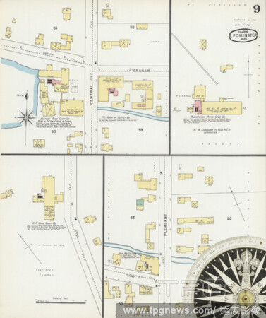
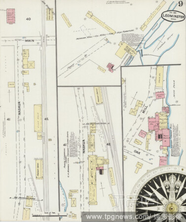
EditorialImage 9 of Sanborn Fire Insurance Map from Leominster, Worcester County, Massachusetts. Feb 1896. 11 Sheet(s), America, street map with a Nineteenth Century compass.
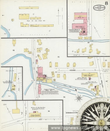
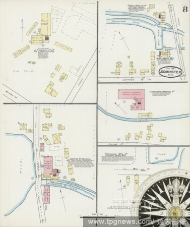
EditorialImage 8 of Sanborn Fire Insurance Map from Leominster, Worcester County, Massachusetts. Feb 1896. 11 Sheet(s), America, street map with a Nineteenth Century compass.
EditorialImage 10 of Sanborn Fire Insurance Map from Leominster, Worcester County, Massachusetts. Apr 1891. 10 Sheet(s), America, street map with a Nineteenth Century compass.
EditorialImage 9 of Sanborn Fire Insurance Map from Leominster, Worcester County, Massachusetts. Apr 1891. 10 Sheet(s), America, street map with a Nineteenth Century compass.
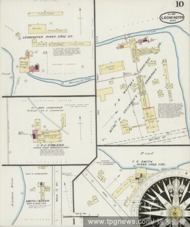
EditorialImage 10 of Sanborn Fire Insurance Map from Leominster, Worcester County, Massachusetts. Feb 1896. 11 Sheet(s), America, street map with a Nineteenth Century compass.
EditorialImage 4 of Sanborn Fire Insurance Map from Leominster, Worcester County, Massachusetts. Apr 1891. 10 Sheet(s), America, street map with a Nineteenth Century compass.
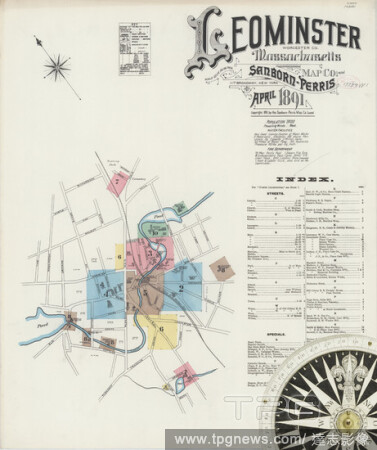
EditorialImage 1 of Sanborn Fire Insurance Map from Leominster, Worcester County, Massachusetts. Apr 1891. 10 Sheet(s), America, street map with a Nineteenth Century compass.
EditorialImage 7 of Sanborn Fire Insurance Map from Leominster, Worcester County, Massachusetts. Jan 1884. 7 Sheet(s), America, street map with a Nineteenth Century compass.
EditorialImage 7 of Sanborn Fire Insurance Map from Leominster, Worcester County, Massachusetts. Feb 1896. 11 Sheet(s), America, street map with a Nineteenth Century compass.
EditorialImage 5 of Sanborn Fire Insurance Map from Leominster, Worcester County, Massachusetts. Jan 1884. 7 Sheet(s), America, street map with a Nineteenth Century compass.
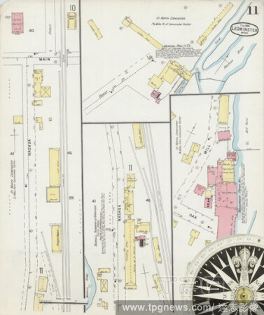
EditorialImage 11 of Sanborn Fire Insurance Map from Leominster, Worcester County, Massachusetts. Feb 1896. 11 Sheet(s), America, street map with a Nineteenth Century compass.
EditorialImage 2 of Sanborn Fire Insurance Map from Leominster, Worcester County, Massachusetts. Jan 1884. 7 Sheet(s), America, street map with a Nineteenth Century compass.
EditorialImage 8 of Sanborn Fire Insurance Map from Leominster, Worcester County, Massachusetts. Apr 1891. 10 Sheet(s), America, street map with a Nineteenth Century compass.
EditorialImage 3 of Sanborn Fire Insurance Map from Leominster, Worcester County, Massachusetts. Apr 1891. 10 Sheet(s), America, street map with a Nineteenth Century compass.
EditorialA prayer for deliverance to the Virgin Mary. Below, the first nine lines of 'King Horn', probably the oldest surviving Middle English Romance. The Harley Lyrics. West Midlands [near Leominster?]; circa 1340. Source: Harley 2253, f.83. Language: Middle ...
EditorialLast six lines of 'Annot and John'; 'Alysoun'; 'The Lover's Complaint'. The Harley Lyrics. West Midlands [near Leominster?]; circa 1340. Source: Harley 2253, f.63v. Language: Middle English.
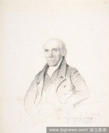
EditorialPortrait of a Gentleman, 1827, Graphite, sheet: 6 1/2 x 5 1/2 in. (16.5 x 14 cm), Drawings, John Scarlett Davis (British, Leominster, Herefordshire 1804?1845 London), Davis drew this portrait while touring Yorkshire between 1825 and 1828. Sir Thomas La...


 Loading