
filter
-
Brand
- By Category
- Direction
- Date Range
199Events
Pictures
Events

Editorial
- 2023-11-01
- 1
Editorial
- 2023-11-01
- 1
Editorial
- 2023-11-01
- 1
Editorial
- 2023-11-01
- 2
Editorial
- 2023-06-15
- 1
Editorial
- 2023-06-07
- 1
Editorial
- 2023-06-07
- 1
Editorial
- 2023-06-07
- 1

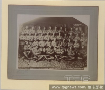
Editorial Lieut. Magee, Non Coms, and men of No, 4 Troop A Squadron, Strathcona's Horse, Ottawa. No. 59163a, 1900.
- 2022-12-24
- 1

Editorial Lieut. Magee, Non Coms, and men of No, 4 Troop A Squadron, Strathcona's Horse, Ottawa. No. 59163a, 1900.
- 2022-12-24
- 1
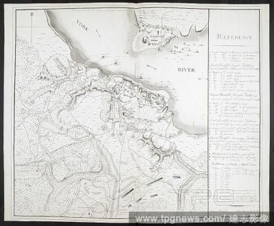
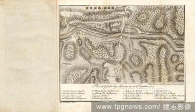
Editorial Plan of Yorktown, showing disposition of American, French and British forces. Drawn by Juliana 12th June 1782 & John Hoyman, Lieut. Inscribed as copy. PLANS of military operations, in North America, etc. 1716-1783. Source: Add. 15535.
- 2022-12-24
- 1
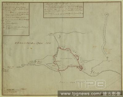
Editorial A plan of the City and Fortress of Louisbourg. Plan of the City and Fortress of LOUISBOURG Surrendered to his Britanick Majesty by Capitulation the 17 June 1745. to Lieut. Genl. Pepperel and Commodore Warren after 55 Days Blockade and 42 days open Tren...
- 2022-12-24
- 1

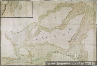
Editorial A plan of part of Canada and the St. Lawrence River which lies between Dechambeaux and Pointe du Lac. The map includes four inset plans; a continuation of the Chaudière River at upper left, two further continuations at lower right, and also an inset p...
- 2022-12-24
- 1
Editorial Plan of that part of Canada and the River St. Lawrence, which lies between the Coteau des Cedres (the uppermost settlements of Canada) and the Island of St. Therese... [Quebec?] : Capt. Holland of the Royal American Regiment ... Lieut. Montresor Engine...
- 2022-12-24
- 1
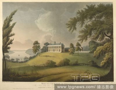
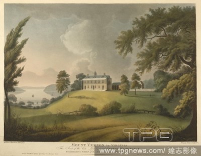
Editorial A view of the Eastern fa?ade of George Washington's two-storey country house with a veranda, colonnade, hipped roof, cupola and dormers built on a mound surrounded by landscaped grounds. Sailing ships can be seen on Potomac River in the background on ...
- 2022-12-24
- 1

Editorial A chart of the north west coast of America and the north east coast of Asia. Chart of the N. W. Coast of America and the N. E. Coast of Asia explored in the years 1778 and 1779. Prepared by Lieut. H. Roberts, under the immediate inspection of Capt. Coo...
- 2022-12-24
- 1
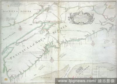
Editorial A chart of the peninsula of Nova Scotia. A CHART OF THE PENINSULA OF NOVA SCOTIA / done by order of His Excellency CHS. LAWRENCE Esqr. Lieut. Govr. & Commr. in Chief of his Majesty's Province of NOVA SCOTIA from many actual Surveys; and the whole corre...
- 2022-12-24
- 1
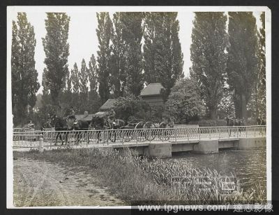
Editorial Field Artillery riding over a bridge [St Floris, France]. Men of the 13th Brigade, Royal Field Artillery under the command of Lieut-Col. Tyler, 30th July 1915. Record of the Indian Army in Europe during the First World War. 20th century, 30th July 1915...
- 2022-12-24
- 1

Editorial Ukraine-Cda-Latvia, Riga, Latvia - 17 Nov 2022
- 2022-11-19
- 1
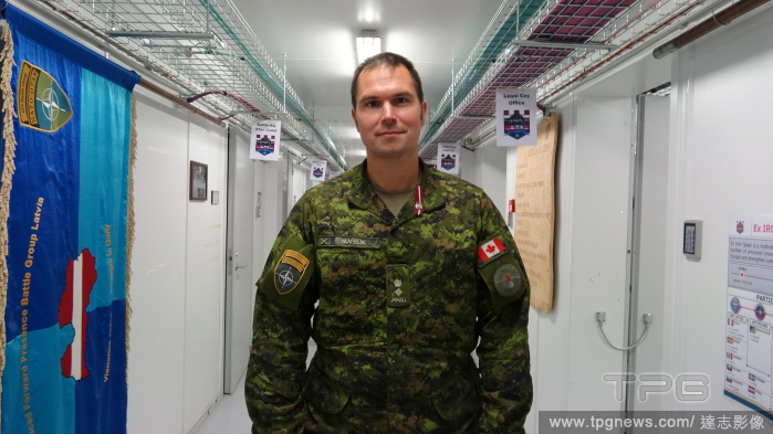
Editorial Canada-Latvia, Riga, Latvia - 16 Nov 2022
- 2022-11-18
- 3
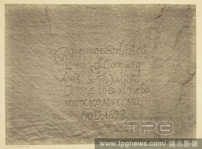
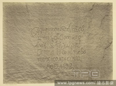
Editorial Historic Spanish Record of the Conquest, South Side of Inscription Rock, N.M. Geographical & Geological Explorations & Surveys West of the 100th Meridian. Expedition of 1873. -Lieut. Geo. M. Wheeler, Corps. of Engineers, Commanding. Timothy O'Sullivan;...
- 2022-07-21
- 1

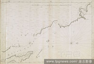
Editorial A chart of part of the south-eastern coast of the North Island of New Zealand, from Cape Runaway to Cape Kidnappers; drawn by Lieut. James Cook, shewing his track in 1769-1770. Charts, Plans, Views, and Drawings taken on board the Endeavour during Capt...
- 2022-04-25
- 1
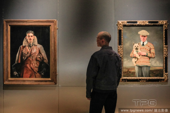
Editorial Fashioning Masculinities: The Art of Menswear photocall at the V&A, London, UK
- 2022-03-16
- 1
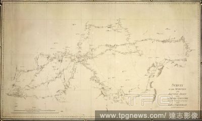
Editorial Survey of the marches of the British Army in the Mysore country during the campaigns of 1791 & 2 under Cornwallis. "Survey of the marches in the Mysore country," 1791, 1792, by Lieut. Robert Hyde Colebrooke.Mysore, India: Survey by Lieut. R. H. Colebro...
- 2022-01-18
- 1
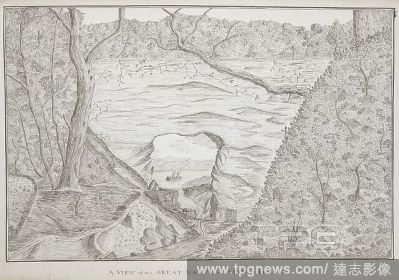
Editorial A view of the great natural arch at Tolaga; drawn by Lieut. James Cook. Charts, Plans, Views, and Drawings taken on board the Endeavour during Captain Cook's First Voyage, 1768-1771. 1769. Source: Add. 7085, No.22.
- 2022-01-18
- 1
Editorial The North Island of New Zealand, by Mr. Molineux, Master of the ' Endeavour': Circ. 1770. CHARTS and maps made during voyages of discovery in the South Pacific Ocean by Samuel Wallis, commander of the "Dolphin," in 1767; Lieut. James Cook, commander of...
- 2022-01-18
- 1
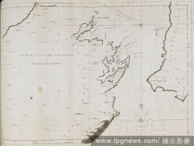
Editorial A chart of Cook's Straits, in New Zealand; drawn by Lieut. James Cook, on a large scale. Charts, Plans, Views, and Drawings taken on board the Endeavour during Captain Cook's First Voyage, 1768-1771. 1770. Ms. 2 f. 3 1/2 in. x 1 f. 7 1/2 in.; 70 x 50 c...
- 2022-01-18
- 1
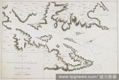
Editorial A plan of Queen Charlotte's Sound, on the southern side of Cook's Straits; drawn by Lieut. James Cook, on a scale of one mile to an inch. Charts, Plans, Views, and Drawings taken on board the Endeavour during Captain Cook's First Voyage, 1768-1771. 177...
- 2022-01-18
- 1

Editorial Plan of Yorktown, showing disposition of American, French and British forces. Drawn by Juliana 12th June 1782 & John Hoyman, Lieut. Inscribed as copy. PLANS of military operations, in North America, etc. 1716-1783. Source: Add. 15535.
- 2022-01-18
- 2
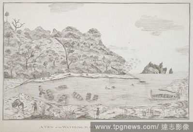
Editorial A view of the watering-place at Tolaga; drawn by Lieut. James Cook. Charts, Plans, Views, and Drawings taken on board the Endeavour during Captain Cook's First Voyage, 1768-1771. 1769. Ms. 1 f. 3 in. x 9 1/2 in.; 38 x 24 cm. Source: Add. 7085, No.21.
- 2022-01-18
- 1

Editorial Plan of that part of Canada and the River St. Lawrence, which lies between the Coteau des Cedres (the uppermost settlements of Canada) and the Island of St. Therese... [Quebec?] : Capt. Holland of the Royal American Regiment ... Lieut. Montresor Engine...
- 2022-01-18
- 2

Editorial A chart of the north west coast of America and the north east coast of Asia. Chart of the N. W. Coast of America and the N. E. Coast of Asia explored in the years 1778 and 1779. Prepared by Lieut. H. Roberts, under the immediate inspection of Capt. Coo...
- 2022-01-18
- 1
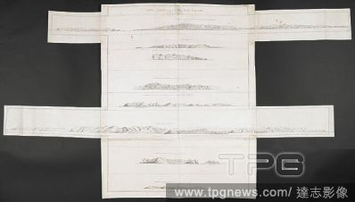
Editorial Various views of headlands on the coasts of New Zealand; drawn by Lieut. James Cook, in his first voyage. Charts, Plans, Views, and Drawings taken on board the Endeavour during Captain Cook's First Voyage, 1768-1771. ca. 1769-1770. Source: Add. 7085, N...
- 2022-01-18
- 1

Editorial A chart of the peninsula of Nova Scotia. A CHART OF THE PENINSULA OF NOVA SCOTIA / done by order of His Excellency CHS. LAWRENCE Esqr. Lieut. Govr. & Commr. in Chief of his Majesty's Province of NOVA SCOTIA from many actual Surveys; and the whole corre...
- 2022-01-18
- 1
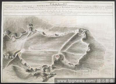
Editorial A survey of part of Gibraltar called the Windmill Hill. PLAN No: 3. A SURVEY of that Part of GIBRALTAR called the WIND-MILL-HILL Exhibiting the running LINE of ENTRENCHMENTS all round the Top Edge of the ROCK Commanding in an EMINENT and POWERFUL degre...
- 2022-01-18
- 1
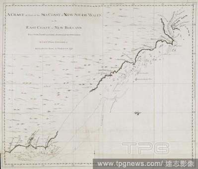
Editorial A chart of part of the sea coast of New South Wales, on the east coast of New Holland, from Point Hickes to Smoaky Cape; drawn by Lieut. James Cook, 1770. Charts, Plans, Views, and Drawings taken on board the Endeavour during Captain Cook's First Voyag...
- 2022-01-18
- 1
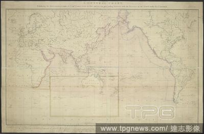
Editorial A general chart exhibiting the discoveries made by Capt. James Cook in this and his two preceeding voyages, with the Tracks of the ships under his command. A General Chart exhibiting the discoveries made by Capt? J. Cook in this and his two preceedin...
- 2022-01-18
- 1
Editorial A chart of part of the sea coast of New South Wales, on the east coast of New Holland, from Cape Tribulation to Endeavour Straits; drawn by Lieut. James Cook, 1770. Charts, Plans, Views, and Drawings taken on board the Endeavour during Captain Cook's F...
- 2022-01-18
- 1
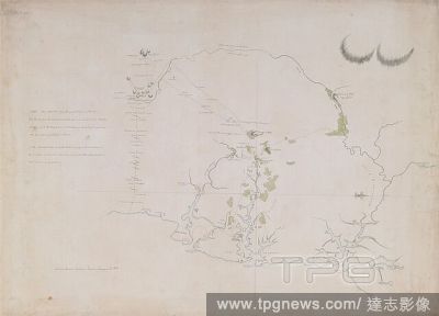
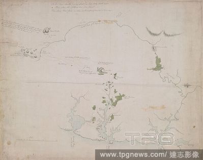
Editorial Survey of Botany and Broken Bays and Port Jackson, in New South Wales, by Captain J[ohn] H[unter]. CHARTS and maps made during voyages of discovery in the South Pacific Ocean by Samuel Wallis, commander of the "Dolphin," in 1767; Lieut. James Cook, com...
- 2022-01-18
- 1
Editorial A chart of part of the north-eastern coast of the North Island of New Zealand, from the Cavalle Isles to the river Thames; drawn by Lieut. James Cook, shewing his track in 1769. Charts, Plans, Views, and Drawings taken on board the Endeavour during Cap...
- 2022-01-18
- 1
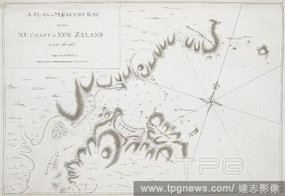
Editorial A plan of Mercury Bay, on the N.E. coast of New Zealand; drawn by Lieut. James Cook, on a scale of one inch to a mile. Charts, Plans, Views, and Drawings taken on board the Endeavour during Captain Cook's First Voyage, 1768-1771. 1769. Ms. 1 f. 4 1/2 i...
- 2022-01-18
- 1

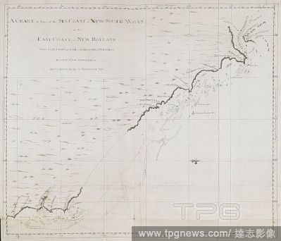
Editorial A chart of part of the sea coast of New South Wales, on the east coast of New Holland, from Smoaky Cape to Cape Townsend; drawn by Lieut. James Cook, 1770. Charts, Plans, Views, and Drawings taken on board the Endeavour during Captain Cook's First Voya...
- 2022-01-18
- 1
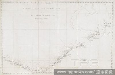
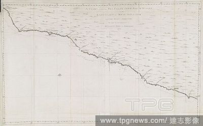
Editorial A chart of the sea coast of New South Wales, on the east coast of New Holland; drawn by Lieut. James Cook, who discovered and explored this coast in 1770. Charts, Plans, Views, and Drawings taken on board the Endeavour during Captain Cook's First Voyag...
- 2022-01-18
- 1

Editorial A plan of the City and Fortress of Louisbourg. Plan of the City and Fortress of LOUISBOURG Surrendered to his Britanick Majesty by Capitulation the 17 June 1745. to Lieut. Genl. Pepperel and Commodore Warren after 55 Days Blockade and 42 days open Tren...
- 2022-01-18
- 1

Editorial A plan of King George's Island, or Otaheite; drawn by Lieut. James Cook in his first voyage, 1769, on a scale of one mile to an inch. . Charts, Plans, Views, and Drawings taken on board the Endeavour during Captain Cook's First Voyage, 1768-1771. 1769...
- 2022-01-18
- 1
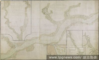
Editorial A plan of part of Canada and the St. Lawrence River which lies between Dechambeaux and Pointe du Lac. The map includes four inset plans; a continuation of the Chaudière River at upper left, two further continuations at lower right, and also an inset p...
- 2022-01-18
- 2

Editorial Various views of lands on the east coast of New South Wales; drawn by Lieut. James Cook, 1770. Charts, Plans, Views, and Drawings taken on board the Endeavour during Captain Cook's First Voyage, 1768-1771. 1770. Source: Add. 7085, No.36.
- 2022-01-18
- 1
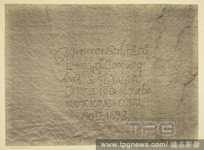
Editorial Historic Spanish Record of the Conquest, South Side of Inscription Rock, N.M. Geographical & Geological Explorations & Surveys West of the 100th Meridian. Expedition of 1873. -Lieut. Geo. M. Wheeler, Corps. of Engineers, Commanding. Timothy O'Sullivan;...
- 2021-10-09
- 1

Editorial Black Ca?on, Colorado River, looking below near Camp 7. Explorations in Nevada and Arizona, Expedition of 1871. Lieut. Geo. M. Wheeler, Com'd'g. Timothy O'Sullivan; American, born Ireland, 1840-1882. Date: 1871. Dimensions: 20.2 x 27.5 cm (image/paper)...
- 2021-10-09
- 1
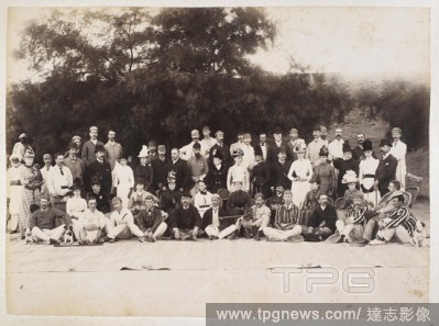
Editorial A European group, Hyderabad. This is most likely Hyderabad in Sindh, not the Deccan. Lieut-Colonel Reilly is sitting in a rattan chair right of centre . 1889. Photograph. Source: Photo 639/3(55).
- 2021-10-09
- 1
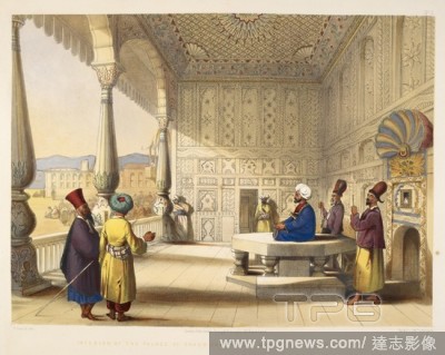
Editorial ‘Interior of the Palace of Shauh Shujah ool Moolk, late King of Caubul’. Costumes and Scenery of Afghaunistaun. Twenty-six lithographs variously by R. Carrick, E. Walker, W. Walton and Hulme after Lieut James Rattray. Hering & Remington, London, 18...
- 2021-10-09
- 1

Editorial Mess Room. Wiltshire Regt. Peshawur, 1886. A view looking along the dining room, with trophy heads and skins lining the wall and the table laid for dinner. Photograph album of Lieut Col C.L. Harvey Wiltshire Regiment and Bengal Staff Corps. 1886. Photo...
- 2021-10-09
- 1

Editorial Soldiers of the 2nd Punjab Cavalry, January 1871. Group photograph. British and Indian officers. . India, January 1871. Photographer: Keyes, Sir Charles Patton Group of British and Indian officers under the command of Lieut-Colonel T.G. Kennedy. Europ...
- 2021-10-09
- 1
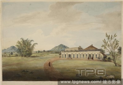
Editorial Bungalow of Lieutenant-Colonel W.R. Gilbert at Hazaribagh. A colonial residence for a military gentleman. The Raj. circa1825. India. . Bungalow of Lieut.-Colonel W.R. Gilbert in Hazaribagh (Bihar). Source: Add. Or. 2514.
- 2021-10-09
- 1

Editorial Reconcilliation Day Toronto, Toronto, Canada - 10 Sep 2021
- 2021-10-01
- 1
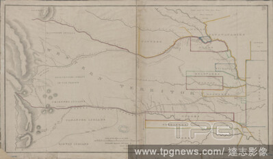
Editorial Dodge expedition route map from Fort Leavenworth to the Rocky Mountains and return, cartographic, Maps, 1836, Steen, (Enoch), Lieut.
- 2021-04-07
- 1
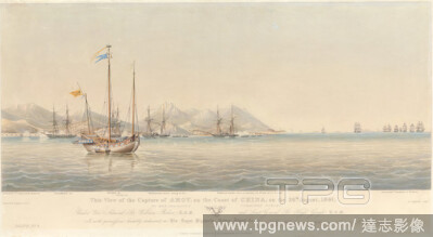
Editorial This View of the Capture of Amoy on the Coast of China, on the 26th August, 1841, by Her Majesty's Combined Forces, under Vice Admiral Sir William Parker K.C.B. and Lieut. General Sir Hugh Gough... Plate 3, Henry Papprill, 1816d.after 1883, American, a...
- 2021-02-21
- 1

Editorial This View of the Capture of Amoy on the Coast of China, on the 26th August, 1841, by Her Majesty's Combined Forces, under Vice Admiral Sir William Parker K.C.B. and Lieut. General Sir Hugh Gough... Plate 1, Henry Papprill, 1816d.after 1883, American, a...
- 2021-02-21
- 1

Editorial funeral of Cornelis Tromp, 1691 Lykstaatsie of Cornelis Tromp, Lieut. Admiral General of Holland and West-Vriesland (title on object), Admission of Admiral Cornelis Tromp by night along the Nieuwe Herengracht in Amsterdam for a yacht that would bring t...
- 2020-12-04
- 1
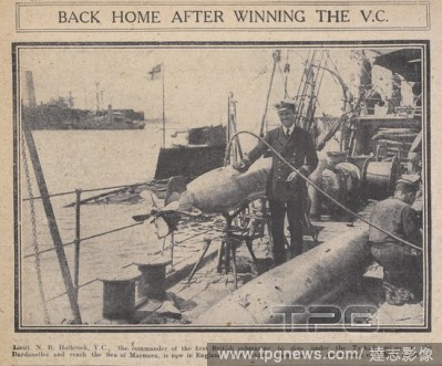
Editorial 'Back home after winning the V.C'. Lieut. N.B. Holbrook, the commander of the first British submarine to dive under the Turkish mines in the Dardanelles and reach the sea of Marmora. He is standing on the deck of H.M.S. Adamant. . Daily Sketch. London,...
- 2020-12-04
- 1

Editorial Photographic portraits of two British officers : Sec-Lieut. Roland C. Larking, 3/4th Norfolk Regiment; and, Sec-Lieut. C. Gordon Larking, 3rd Royal Sussex Regiment. South Eastern Gazzette. England, 1916. Source: South Eastern Gassette, 08 February 1916...
- 2020-12-04
- 1
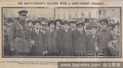
Editorial The heavy-weight's platoon with a light weight segreant. Lieut. Victor McLaglan, the heavyweight boxer who was considered a possible world's champion, raised a platoon of his own with the help of Johnny Summers, the well-known lightweight, in Trafalgar...
- 2020-12-04
- 1
Editorial A view of the Eastern fa?ade of George Washington's two-storey country house with a veranda, colonnade, hipped roof, cupola and dormers built on a mound surrounded by landscaped grounds. Sailing ships can be seen on Potomac River in the background on ...
- 2020-12-02
- 1
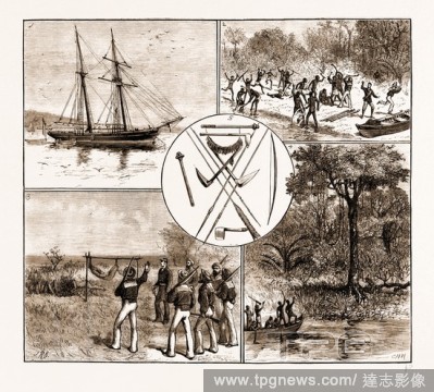
Editorial THE MASSACRE OF LIEUT. BOWER AND FIVE SEAMEN OF H.M.S. "SANDFLY" IN THE SOLOMON ISLANDS, 1881: 1. H.M. Schooner Sandfly in Port Jackson. 2. The Attack on Lieut. Bower and the Boat's Crew. 3. Finding the Bodies of Venton, Carne, and Paterson. 4. The Nat...
- 2020-12-01
- 1

Editorial Survey of Botany and Broken Bays and Port Jackson, in New South Wales, by Captain J[ohn] H[unter]. CHARTS and maps made during voyages of discovery in the South Pacific Ocean by Samuel Wallis, commander of the "Dolphin," in 1767; Lieut. James Cook, com...
- 2020-11-26
- 1

Editorial A plan of the entrance of Endeavour River, in New South Wales; drawn by Lieut. James Cook, on a scale of 4 1/2 inches to a mile. Charts, Plans, Views, and Drawings taken on board the Endeavour during Captain Cook's First Voyage, 1768-1771. 1770. Ms. 1 ...
- 2020-11-26
- 1

Editorial A sketch of Botany Bay, in New South Wales; drawn by Lieut. James Cook, on a scale of one league to a mile. Charts, Plans, Views, and Drawings taken on board the Endeavour during Captain Cook's First Voyage, 1768-1771. 1770. Ms. 1 f. 1 1/2 in. x 1 f.; ...
- 2020-11-26
- 1

Editorial A chart of part of the sea coast of New South Wales, on the east coast of New Holland, from Cape Townsend to Cape Tribulation; drawn by Lieut. James Cook, 1770. Charts, Plans, Views, and Drawings taken on board the Endeavour during Captain Cook's First...
- 2020-11-26
- 1

Editorial A chart of part of the sea coast of New South Wales, on the east coast of New Holland, from Smoaky Cape to Cape Townsend; drawn by Lieut. James Cook, 1770. Charts, Plans, Views, and Drawings taken on board the Endeavour during Captain Cook's First Voya...
- 2020-11-26
- 1

Editorial A chart of the sea coast of New South Wales, on the east coast of New Holland; drawn by Lieut. James Cook, who discovered and explored this coast in 1770. Charts, Plans, Views, and Drawings taken on board the Endeavour during Captain Cook's First Voyag...
- 2020-11-26
- 1

Editorial Various views of lands on the east coast of New South Wales; drawn by Lieut. James Cook, 1770. Charts, Plans, Views, and Drawings taken on board the Endeavour during Captain Cook's First Voyage, 1768-1771. 1770. Source: Add. 7085, No.36.
- 2020-11-26
- 1

Editorial A chart of part of the sea coast of New South Wales, on the east coast of New Holland, from Point Hickes to Smoaky Cape; drawn by Lieut. James Cook, 1770. Charts, Plans, Views, and Drawings taken on board the Endeavour during Captain Cook's First Voyag...
- 2020-11-26
- 1
Editorial A chart of part of the sea coast of New South Wales, on the east coast of New Holland, from Cape Tribulation to Endeavour Straits; drawn by Lieut. James Cook, 1770. Charts, Plans, Views, and Drawings taken on board the Endeavour during Captain Cook's F...
- 2020-11-26
- 1

Editorial Mosque and Tomb of the Emperor Soolta Mahmood of Ghuznee. Lieut. James Rattray's Scenery, Inhabitants, and Costumes of Afghaunistan. London : Hering & Remington, 1848. Lithograph. Source: X 562, plate 10.
- 2020-09-29
- 1
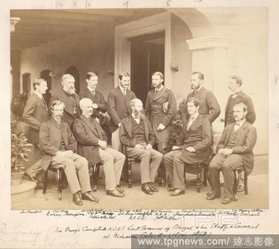
Editorial Sir George Campbell. 1874. Sir George Campbell K.C.S.I. Lieut. Governor of Bengal & his Staff & Council, at Belvedere, Calcutta. Group portrait on the verandah of Belvedere. A key on the mount of the print identifies the figures as follows: (standing l...
- 2020-09-28
- 1

Editorial A plan of King George's Island, or Otaheite; drawn by Lieut. James Cook in his first voyage, 1769, on a scale of one mile to an inch. . Charts, Plans, Views, and Drawings taken on board the Endeavour during Captain Cook's First Voyage, 1768-1771. 1769...
- 2020-09-28
- 1

Editorial Mosque of Goolaum Hoosein Huzrut-Jee, a great prophet of the Afghauns. Lieut. James Rattray's Scenery, Inhabitants, and C. London : Hering & Remington, 1848. Lithograph. Source: X 562, plate 30.
- 2020-09-28
- 1
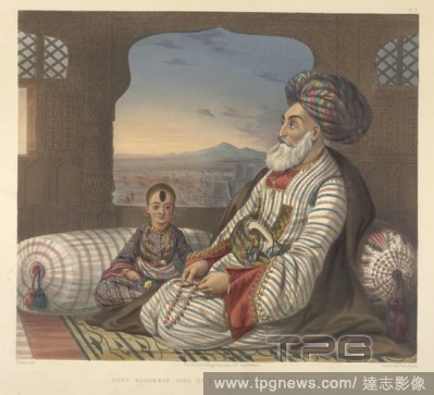
Editorial Dost Mahommed King of Caubul and his youngest son. Lieut. James Rattray's Scenery, Inhabitants, and Costumes of Afghaunistan. London : Hering & Remington, 1848. Source: X 562, plate 2.
- 2020-09-28
- 1

Editorial A chart of the north west coast of America and the north east coast of Asia. Chart of the N. W. Coast of America and the N. E. Coast of Asia explored in the years 1778 and 1779. Prepared by Lieut. H. Roberts, under the immediate inspection of Capt. Coo...
- 2020-09-28
- 1

Editorial Afghaun Foot Soldiers in their Winter Dress, with entrance to the valley of Urgundeh. Lieut. James Rattray's Scenery, Inhabitants, and Costumes of Afghaunistan. London : Hering & Remington, 1848. Source: X 562, plate 11.
- 2020-09-28
- 1
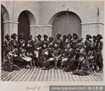
Editorial Soldiers of the 2nd Punjab Cavalry, January 1871. Group photograph. British and Indian officers. . India, January 1871. Photographer: Keyes, Sir Charles Patton Group of British and Indian officers under the command of Lieut-Colonel T.G. Kennedy. Europ...
- 2020-09-28
- 1

Editorial Bungalow of Lieutenant-Colonel W.R. Gilbert at Hazaribagh. A colonial residence for a military gentleman. The Raj. circa1825. India. . Bungalow of Lieut.-Colonel W.R. Gilbert in Hazaribagh (Bihar). Source: Add. Or. 2514.
- 2020-09-28
- 1
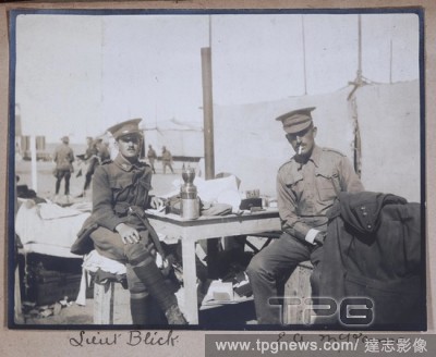
Editorial Photograph - Lieut. Blick & Capt. McKenna, Egypt, Captain Edward Albert McKenna, World War I, 1914-1915, One of 139 photographs in an album from World War I likely to have been taken by Captain Edward Albert McKenna. The photographs include the 7th Bat...
- 2020-01-15
- 1
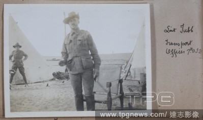
Editorial Photograph - 'Lieut Tubb', Captain Edward Albert McKenna, World War I, 1914-1915, One of 139 photographs in an album from World War I likely to have been taken by Captain Edward Albert McKenna. The photographs include the 7th Battalion training in Mena...
- 2020-01-15
- 1
Editorial Plan of the battle at Almaraz on December 25, 1808, Plan of Troops at the Battle of Almaraz, signed: Gez., v, Ludwig, Lieut, D., v, Ant. Karcher, Fig. 1, to p. 530, Ludwig, Damian (gez.); Karcher, Anton (gest.), Franz Xaver Rigel: Der siebenj?hrige Kam...
- 2020-01-15
- 1
Editorial funeral of Cornelis Tromp, 1691 Lykstaatsie of Cornelis Tromp, Lieut. Admiral General of Holland and West-Vriesland (title on object), Admission of Admiral Cornelis Tromp by night along the Nieuwe Herengracht in Amsterdam for a yacht that would bring t...
- 2019-11-19
- 1

Editorial Winter camp. Narrative of a Journey to the Shores of the Polar. J. Murray: London, 1823. Manner of making a resting place on a winters night. March 15th 1820. Image taken from Narrative of a Journey to the Shores of the Polar Sea, in the years 1819, 2...
- 2019-11-19
- 1
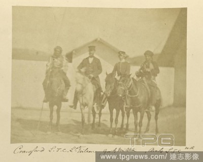
Editorial Crawford L.T.C., Lieut. Wilson, Gorti Militia, Arabs L.T.C., Dr. William Robertson (Scottish, 1818 - 1882), Turkey, 1855 - 1856, Albumen silver print, 8.1 ? 10.4 cm (3 3/16 ? 4 1/8 in.).
- 2019-11-19
- 1
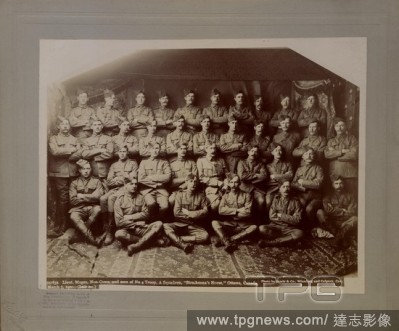
Editorial Lieut. Magee, Non Coms, and men of No, 4 Troop A Squadron, Strathcona's Horse, Ottawa. No. 59163a, 1900.
- 2019-11-19
- 1
Editorial Lieut. Magee, Non Coms, and men of No, 4 Troop A Squadron, Strathcona's Horse, Ottawa. No. 59163a, 1900.
- 2019-11-19
- 1
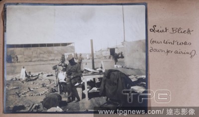
Editorial Photograph - 'Lieut. Blick', Egypt, Captain Edward Albert McKenna, World War I, 1914-1915, One of 139 photographs in an album from World War I likely to have been taken by Captain Edward Albert McKenna. The photographs include the 7th Battalion trainin...
- 2019-11-18
- 1
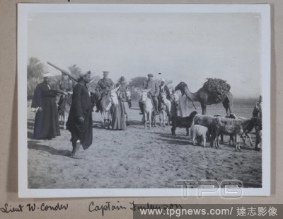
Editorial Photograph - 'Lieut. W. Conder, Captain Finlayson', Egypt, Captain Edward Albert McKenna, World War I, 1914-1915, One of 139 photographs in an album from World War I likely to have been taken by Captain Edward Albert McKenna. The photographs include th...
- 2019-11-18
- 1
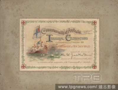
Editorial Invitation - To Lieut-Colonel W. J. Ferris & Mrs Ferris, Commonwealth of Australia Inaugural Celebrations at Sydney, 1 Jan 1901, Invitation addressed to Lieutenant Colonel W.J.Ferris and Mrs Ferris from the Government of New South Wales. The invitation...
- 2019-11-18
- 1
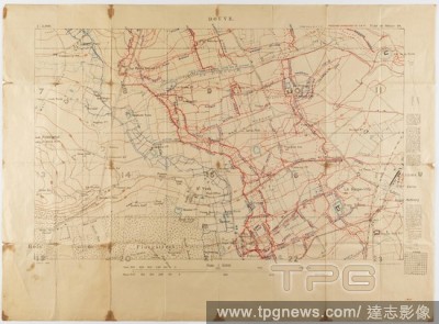
Editorial Map - Military, Trench, France, Douve, Sheet 28, Scale 1:5,000, World War I, May 1917, Alternative Name(s): Military Map Ordnance Survey trench map, Douve, France, World War I, dated May 1917. Part of sheet 28. Scale 1:5,000. Trenches corrected to 1:4:...
- 2019-11-18
- 1
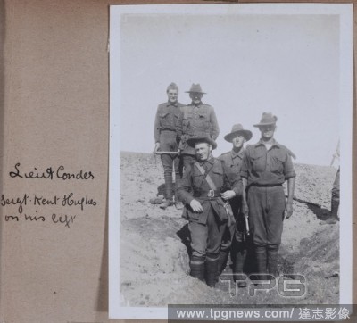
Editorial Photograph - Lieut. Conder & Sergt. Hughes, Egypt, Captain Edward Albert McKenna, World War I, 1914-1915, One of 139 photographs in an album from World War I likely to have been taken by Captain Edward Albert McKenna. The photographs include the 7th Ba...
- 2019-11-18
- 1

Editorial Invitation - To Lieut-Colonel W. J. Ferris & Mrs Ferris, Commonwealth of Australia Inaugural Celebrations at Sydney, 1 Jan 1901, Invitation addressed to Lieutenant Colonel W.J.Ferris and Mrs Ferris from the Government of New South Wales. The invitation...
- 2019-11-18
- 1
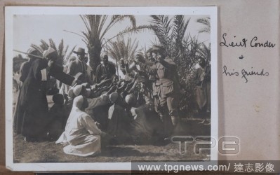
Editorial Photograph - 'Lieut. Conder & His Friends', Egypt, Captain Edward Albert McKenna, World War I, 1914-1915, One of 139 photographs in an album from World War I likely to have been taken by Captain Edward Albert McKenna. The photographs include the 7th Ba...
- 2019-11-18
- 1

Editorial Historic Spanish Record of the Conquest, South Side of Inscription Rock, N.M. Geographical & Geological Explorations & Surveys West of the 100th Meridian. Expedition of 1873. -Lieut. Geo. M. Wheeler, Corps. of Engineers, Commanding. Timothy O'Sullivan;...
- 2019-04-01
- 1
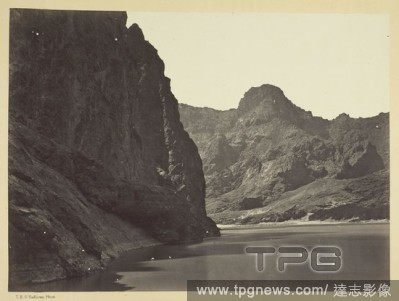
Editorial Black Ca?on, Colorado River, looking below near Camp 7. Explorations in Nevada and Arizona, Expedition of 1871. Lieut. Geo. M. Wheeler, Com'd'g. Timothy O'Sullivan; American, born Ireland, 1840-1882. Date: 1871. Dimensions: 20.2 x 27.5 cm (image/paper)...
- 2019-04-01
- 1
Editorial Historic Spanish Record of the Conquest, South Side of Inscription Rock, N.M. Geographical & Geological Explorations & Surveys West of the 100th Meridian. Expedition of 1873. -Lieut. Geo. M. Wheeler, Corps. of Engineers, Commanding. Timothy O'Sullivan;...
- 2019-03-18
- 1
 Loading