
filter
-
Brand
- By Category
- Direction
- Date Range
90Events
Pictures
Events

Editorial
- 2024-05-22
- 3

Editorial
- 2023-11-14
- 1

Editorial NOEX
- 2023-11-09
- 1

Editorial NOEX
- 2023-11-08
- 1
Editorial NOEX
- 2023-06-07
- 1

Editorial Tea Strainer. W.H. Saxton, Jr.; American, active 1891-1896; New London, Connecticut. Date: 1891-1896. Dimensions: 2.5 ? 6 cm (7/8 ? 2 3/8 in.). Silver. Origin: New London.
- 2022-04-24
- 1

Editorial Women's Final Four 2022 in Minneapolis
- 2022-04-04
- 4

Editorial President Trump Talks About Tax Cuts, Washington, District of Columbia, United States - 12 Apr 2018
- 2021-09-06
- 2

Editorial President Trump Talks About Tax Cuts, Washington, District of Columbia, United States - 12 Apr 2018
- 2021-07-13
- 3

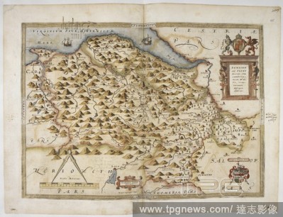
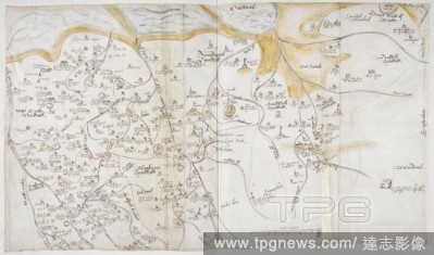
Editorial Coloured manuscript map of the south coast of Devon and Dorset, from Dartmouth to Weymouth, with a description of Ottermouth Haven. Lord Burghley's Atlas. London; 1579. SAXTON, SAXTON's. Source: Royal 18 D. III, ff.9v-10. Language: English.
- 2020-12-02
- 1
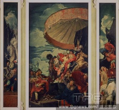
Editorial TRIUNFO DE APOLO - 1913 - SALA DE LOS BUCRANEOS DE LA KENT HOUSE DE SIR SAXTON NOBLE EN LONDRES - GRISALLA EN NEGRO Y ORO SOBRE LIENZO 262 x 441 cm. SERT JOSE MARIA.
- 2019-09-16
- 1

Editorial Sailing : READY STEADY TOKYO - Sailing
- 2019-08-22
- 1

Editorial Sailing : READY STEADY TOKYO
- 2019-08-21
- 2

Editorial VANESSA HUDGENS , ALY MICHALKA , RYAN DONOWHO , GAELAN CONNELL , CHARLIE SAXTON and TIM JO in BANDSLAM (2009).
- 2019-06-21
- 6

Editorial VANESSA HUDGENS , ALY MICHALKA , RYAN DONOWHO , GAELAN CONNELL , CHARLIE SAXTON and TIM JO in BANDSLAM (2009).
- 2019-06-06
- 6
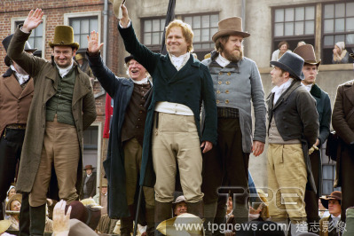
Editorial PETERLOO
- 2019-04-09
- 2

Editorial Tea Strainer. W.H. Saxton, Jr.; American, active 1891-1896; New London, Connecticut. Date: 1891-1896. Dimensions: 2.5 ? 6 cm (7/8 ? 2 3/8 in.). Silver. Origin: New London.
- 2019-03-18
- 1

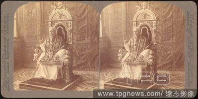
Editorial [Group of 12 Stereograph Views of Celebrities, Including Popes and Presidents].
- 2019-02-15
- 1

Editorial XYZ Films party at Sundance
- 2019-02-02
- 2

Editorial XYZ Films party at Sundance
- 2019-02-02
- 2
Editorial Map of Lancashire, 1577. Lord Burghley's Atlas. Maps of counties of England and Wales, printed and coloured; from drawings by Christopher Saxton. England [London], 1579. Source: Royal 18 D. III f.80. Language: English.
- 2018-12-06
- 1
Editorial Coloured plan of Scarborough Castle, on the Yorkshire coast. . Lord Burghley's Atlas. Maps of counties of England and Wales, printed and coloured; from drawings by Christopher Saxton. England [London], 1579. Source: Royal 18 D. III f.65. Language: English.
- 2018-12-06
- 1
Editorial Plan of Shrewsbury. Lord Burghley's Atlas. London; 1579. Source: Royal 18 D. III, ff.89v-90. Language: English.
- 2018-12-06
- 1
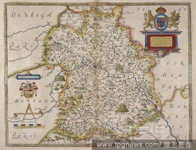
Editorial Map of Anglesey and Wales. Lord Burghley's Atlas. Maps of counties of England and Wales, printed and coloured; from drawings by Christopher Saxton. England [London], 1579. SAXTON, SAXTON'S. Source: Royal 18 D. III f.117r. Language: English.
- 2018-12-06
- 1

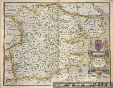
Editorial A map of Essex. Essexi? Comitat. nova ... descriptio ... 1576. Christophorus Saxton descripsit. [London], 1576. Source: Maps C.3.bb.5, page 12. Language: Latin.
- 2018-12-06
- 1
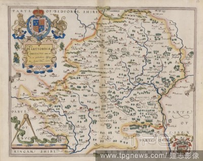
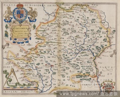
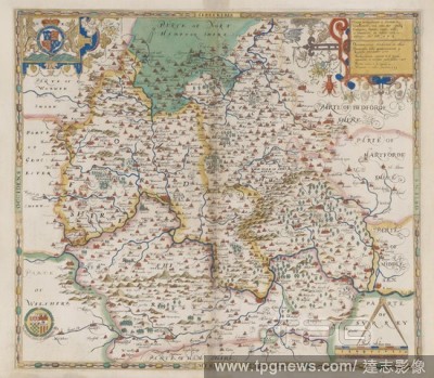
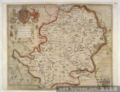
Editorial Hertfordshire. Atlas of the Counties of England and Wales. London, 1579. Map of Hertfordshire. Image taken from Atlas of the Counties of England and Wales. Originally published/produced in 1579. Source: Maps.C.3.bb.5, 13.
- 2018-12-06
- 2
Editorial Map with the title 'Radnor Breknok, Cardigan et Caermarden ...' (Radnorshire, Brecon, South Wales). Lord Burghley's Atlas. Maps of counties of England and Wales, printed and coloured; from drawings by Christopher Saxton. England [London], 1579. Source:...
- 2018-12-06
- 1

Editorial Map of Monmouth, Wales. Lord Burghley's Atlas. Maps of counties of England and Wales, printed and coloured; from drawings by Christopher Saxton. England [London], 1579. Source: Royal 18 D. III f.101. Language: English.
- 2018-12-06
- 1

Editorial Map of Shropshire (Salop), West Midlands. Lord Burghley's Atlas. Maps of counties of England and Wales, printed and coloured; from drawings by Christopher Saxton. England [London], 1579. SAXTON, SAXTON'S. Source: Royal 18 D. III f.86. Language: English.
- 2018-12-06
- 1
Editorial Map of Westmoreland and Cumberland, 1576. Lord Burghley's Atlas. Maps of counties of England and Wales, printed and coloured; from drawings by Christopher Saxton. England [London], 1579. Source: Royal 18 D. III f.75. Language: English.
- 2018-12-06
- 1
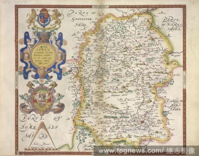
Editorial Map with title 'Glosestria' (Gloucester). Lord Burghley's Atlas. Maps of counties of England and Wales, printed and coloured; from drawings by Christopher Saxton. England [London], 1579. Source: Royal 18 D. III f.97. Language: English.
- 2018-12-06
- 1
Editorial A map of Hertfordshire. Hartfordi? Comitatus nova ... descriptio ... 1577. C. Saxton descripsit & Nicholas Reynoldus Londinensis sculpsit. [London], 1577. Source: Maps C.3.bb.5, page 13. Language: Latin.
- 2018-12-06
- 1
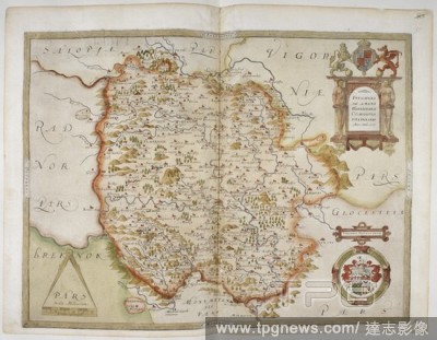
Editorial Devon. Atlas of the Counties of England and Wales. London, 1579. Map of Devon. Image taken from Atlas of the Counties of England and Wales. Originally published/produced in 1579. Source: Maps.C.3.bb.5, 10.
- 2018-12-06
- 1
Editorial Printed map of Devon, dated 1575, with marginal notes by Lord Burghley relating to the defence of the county. Lord Burghley's Atlas. London; 1579. Source: Royal 18 D. III, ff.11v-12. Language: English.
- 2018-12-06
- 1
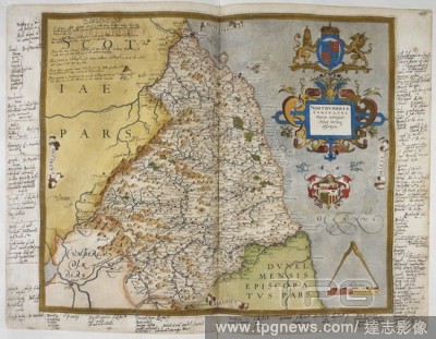
Editorial A map of Northumberland. Northumbri? Comitatus (Scoti? contigu?) Nova Vera descriptio. C. Saxton descripsit. [London], [1576?]. Source: Maps C.7.c.2, page 13.
- 2018-12-06
- 1
Editorial Map of Devon. Devoni? Comitat. ... descriptio ... [London], 1575. Source: Maps.C.7.c.1.6.(10). Language: Latin.
- 2018-12-06
- 1

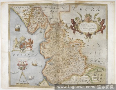
Editorial Map of Lancashire. Lancastri? Comitatus palatin ... descriptio ... [London], 1577. Source: Maps.C.7.c.1.24.(28). Language: Latin.
- 2018-12-06
- 1
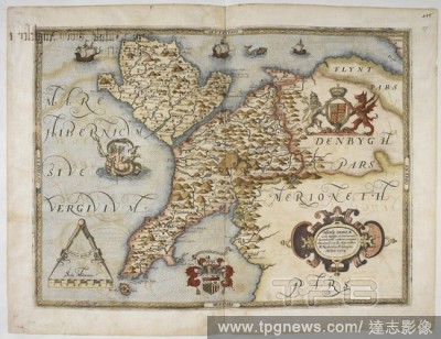
Editorial Map with title 'Denbigh and Flint', but showing most of North Wales. Lord Burghley's Atlas. Maps of counties of England and Wales, printed and coloured; from drawings by Christopher Saxton. England [London], 1579. Source: Royal 18 D. III f.115. Languag...
- 2018-12-06
- 1

Editorial Map of Montgomeryshire and Merionethshire. Montgomeri ac Merionidh ... descriptio ... 1578. Source: Maps.C.7.c.1.32.(36). Language: Latin.
- 2018-12-06
- 1

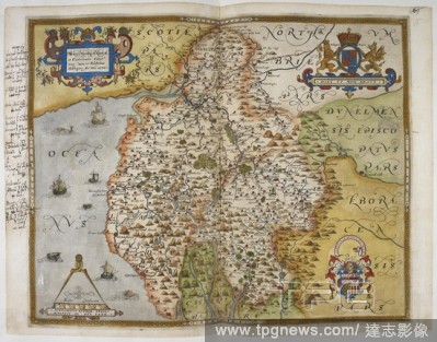
Editorial Map of County Durham, 1576. Lord Burghley's Atlas. Maps of counties of England and Wales, printed and coloured; from drawings by Christopher Saxton. England [London], 1579. Source: Royal 18 D. III f.68. Language: English.
- 2018-12-06
- 1
Editorial Engraved map of Northumberland, from drawings of Christopher Saxton. Dedicated to Queen Elizabeth I. With annotations in the hand of Lord Burghley. Lord Burghley's Atlas. London; 1579. Source: Royal 18 D. III, ff.71v-72. Language: English.
- 2018-12-06
- 1

Editorial Essex. Atlas of the Counties of England and Wales. London, 1579. Source: Maps.C.3.bb.5, 12.
- 2018-12-06
- 1
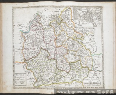
Editorial A map of Oxford, Buckinghamshire and Berkshire. All the Shires of England and Wales Described by Christopher Saxton Being the Best and Original Mapps With many Additions and Corrections by Philip Lea. A table of the Shires. [London] : Sold by Phillip L...
- 2018-12-06
- 1
Editorial Map of Wiltshire. Wiltoni? Comitatus ... hic ob oculos proponitur. [London], 1576. Source: Maps.C.7.c.1.4.(8). Language: Latin.
- 2018-12-06
- 1
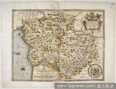
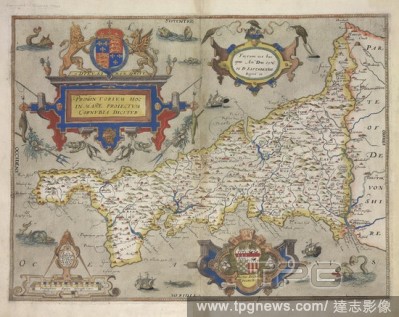
Editorial Saxton's map of Cornwall, dated 1576. Lord Burghley's Atlas. London; 1579. Source: Royal 18 D. III, f.8. Language: English.
- 2018-12-06
- 1
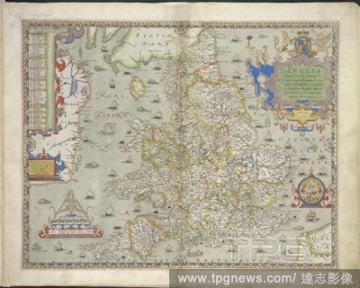
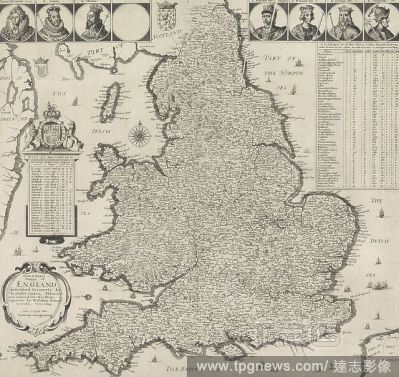
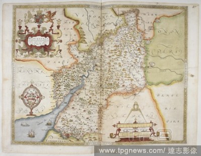
Editorial England and Wales. Atlas of the Counties of England and Wales. London, 1579. Map of England and Wales. Image taken from Atlas of the Counties of England and Wales. Originally published/produced : 1579. Source: Maps.C.7.c.1, 4.
- 2018-12-06
- 2
Editorial Map of Herefordshire, 1577. Lord Burghley's Atlas. Maps of counties of England and Wales, printed and coloured; from drawings by Christopher Saxton. England [London], 1579. SAXTON'S SAXTON. Source: Royal 18 D. III f.95. Language: English.
- 2018-12-06
- 1
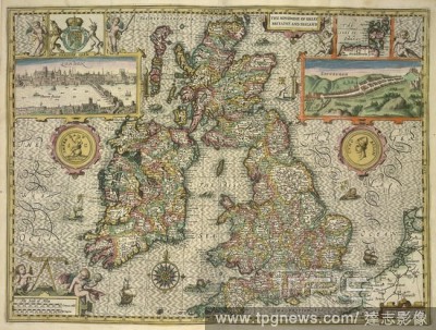
Editorial A map of Great Britain and Ireland. The Kingdome of England. Described by Christopher Saxton, augmented by John Speed ... Jodocus Hondius Flander caelavit ... 1610. (A Catalogue of all the Shires, Cities, Bishoprickes, Market-Townes, Castles, Parishes,...
- 2018-12-06
- 1
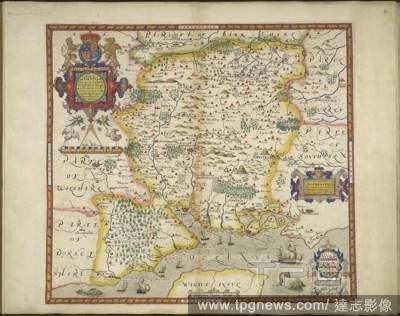
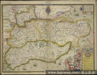
Editorial Hampshire. Atlas of the Counties of England and Wales. London, 1579. Map of Hampshire. Image taken from Atlas of the Counties of England and Wales. Originally published/produced : 1579. Source: Maps.C.3.bb.5, 6.
- 2018-12-06
- 1

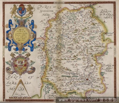
Editorial Wiltshire. Atlas of the Counties of England and Wales. London, 1579. Map of Wiltshire. Image taken from Atlas of the Counties of England and Wales. Originally published/produced in 1579. Source: Maps.C.3.bb.5, 8.
- 2018-12-06
- 1

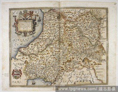
Editorial Map with the title 'Penbrok' (Pembrokshire, West Wales). Lord Burghley's Atlas. Maps of counties of England and Wales, printed and coloured; from drawings by Christopher Saxton. England [London], 1579. Source: Royal 18 D. III f.110. Language: English.
- 2018-12-06
- 2
Editorial Map with the title 'Montgomeri' (Montgomery, North Wales). Lord Burghley's Atlas. Maps of counties of England and Wales, printed and coloured; from drawings by Christopher Saxton. England [London], 1579. Source: Royal 18 D. III f.112. Language: English.
- 2018-12-06
- 1

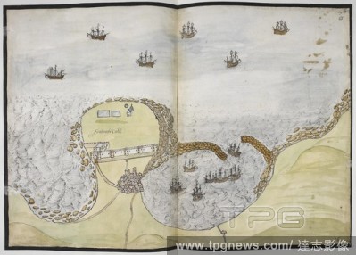
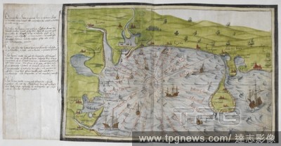
Editorial Coloured manuscript plan of Falmouth Haven, or Harbour. Lord Burghley's Atlas. London; 1579. Source: Royal 18 D. III, ff.15v-16. Language: English.
- 2018-12-06
- 1
Editorial A 16th century map of Lancashire, by Saxton. Lord Burghley's Atlas. London; 1579. Source: Royal 18 D. III, ff.81v-82. Language: English.
- 2018-12-06
- 1
Editorial Oxfordshire and Berkshire. Atlas of the Counties of England and Wales. London, 1579. Source: Maps.C.3.bb.5, 14.
- 2018-12-06
- 1
Editorial Map of Shropshire. Salopi? Comitatus ... descriptionem h?c tibi tabula refert ... [London], 1577. Source: Maps.C.7.c.1.18.(22). Language: Latin.
- 2018-12-06
- 1

Editorial A map of the English and Scottish borders. Lord Burghley's Atlas. London; 1579. Source: Royal 18 D. III, f.76. Language: English.
- 2018-12-06
- 1
Editorial Map with the title 'Glamorga' (Glamorgan, South Wales). Lord Burghley's Atlas. Maps of counties of England and Wales, printed and coloured; from drawings by Christopher Saxton. England [London], 1579. Source: Royal 18 D. III f.105. Language: English.
- 2018-12-06
- 1

Editorial Coloured printed map of Wales and Anglesey. Lord Burghley's Atlas. London; 1579. Source: Royal 18 D. III, ff.98v-99. Language: English.
- 2018-12-06
- 1
Editorial Coloured manuscript map of the south coast of Devon and Dorset, from Dartmouth to Weymouth, with a description of Ottermouth Haven. Lord Burghley's Atlas. London; 1579. SAXTON, SAXTON's. Source: Royal 18 D. III, ff.9v-10. Language: English.
- 2018-12-06
- 1
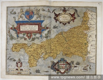
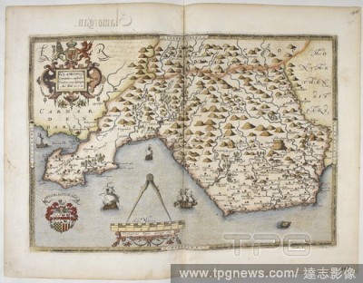
Editorial Cornwall. Promontorium hoc ... Cornubia dicitur ... 1576. C. London, 1579. Map of Cornwall. Image taken from Promontorium hoc Cornubia dicitur 1576. C. Saxton descripsit. L. Terwoort Antverpianus sculpsit. In: C. Saxton's Atlas of England and Wales. Or...
- 2018-12-06
- 1
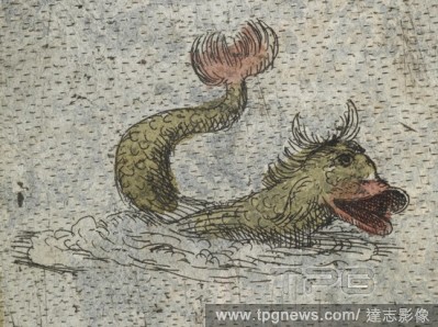
Editorial Detail, showing a fish. Lord Burghley's Atlas. London, 1579. Source: Royal 18 D. III, f.8 detail.
- 2018-12-06
- 1

Editorial Hertfordshire. Hartfordi? Comitatus nova descriptio 1577.C. Saxton descripsit & Nicholas Reynoldus Londinensis sculpsit. C. Saxton's Atlas of England and Wales. [London], 1577. Source: Maps.C.7.c.1, 13.
- 2018-12-06
- 1
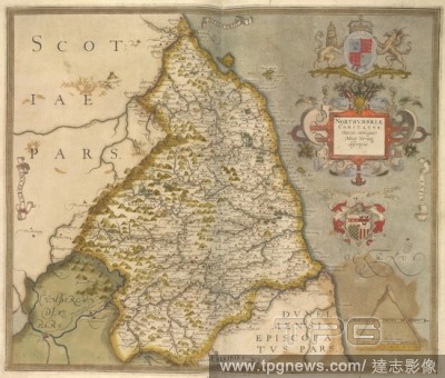
Editorial Map of Northumbria. An atlas of England and Wales, containing 35 coloured maps , drawn by Christopher Saxton and engraved by A. Ryther, R. Hogenberg, C. Hogius, N. Reynolds, L. Terwoort and F. Scatter. London, [1574-]1579. Source: Maps.C.3.bb.5.
- 2018-12-06
- 1

Editorial Cornwall. An atlas of England and Wales, containing 35 colou. London, 1579. Map of Cornwall. Image taken from An atlas of England and Wales, containing 35 coloured maps, drawn by Christopher Saxton and engraved by A. Ryther, R. Hogenberg, C. Hogius, N....
- 2018-12-06
- 2
Editorial Devon. C. Saxton's Atlas of England and Wales. [London], 1575. Devoni? Comitat. descriptio 1575.Christophorus Saxton descripsit.. Image taken from C. Saxton's Atlas of England and Wales. Originally published/produced in 1575. Source: Maps.C.7.c.1, 10.
- 2018-12-06
- 1
Editorial Suffolk. C. Saxton's Atlas of England and Wales. [London], 1575. Suffolci? Comitatus Vera descriptio:Christophorus Saxton descripsit.. Image taken from C. Saxton's Atlas of England and Wales. Originally published/produced in 1575. (The shelfmark for t...
- 2018-12-06
- 1
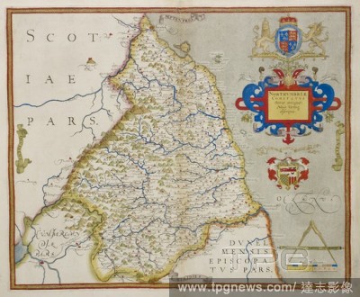
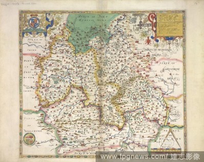
Editorial Map of Hertforshire. MAPS OF COUNTIES of England and Wales, printed and coloured; from drawings by Christopher Saxton (d. 1595). (Burghley Atlas). Source: Royal 18 D. III, ff.33v-34.
- 2018-12-06
- 1

Editorial Map of Yorkshire. EBORACENSIS Comitatus. MAPS OF COUNTIES of England and Wales, printed and coloured; from drawings by Christopher Saxton. 1577. Source: Royal 18 D. III, ff.60v-61.
- 2018-12-06
- 1
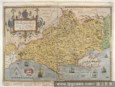
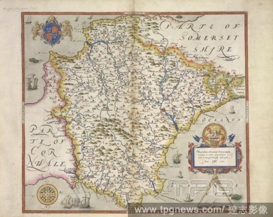
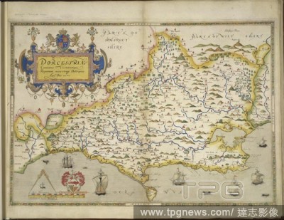
Editorial Map of Dorset. Lord Burghley's Atlas. England [London], 1579. [Whole map] Printed map of Dorset, from drawing by Christopher Saxton, 1575. The work was undertaken for Thomas Sackville, Master of Requests, and dedicated to Queen Elizabeth I. Source: Roy...
- 2018-12-06
- 1

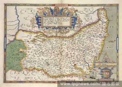
Editorial Herefordshire. C. Saxton's Atlas of England and Wales. [London], 1577. Frugiferi ac ameni Herefordi? comitatus deliniatio 1577.C. Saxton descripsit. R. hogenbergius [sculpsit]. Image taken from C. Saxton's Atlas of England and Wales. Originally publis...
- 2018-12-06
- 1

Editorial Southampton. C. Saxton's Atlas of England and Wales. [London], 1575. Southamtoni? Comitatus vera descriptio.Christophorus Saxton descripsit.. Image taken from C. Saxton's Atlas of England and Wales. . Originally published/produced in 1575. Source: Map...
- 2018-12-06
- 1
Editorial Sussex and Kent. An atlas of England and Wales, containing 35 colou. London, 1579. A map of Sussex and Kent, with parts of Essex, Buckinghamshire, Bekshire, Hampshire and Middlesex. Image taken from An atlas of England and Wales, containing 35 coloured...
- 2018-12-06
- 2

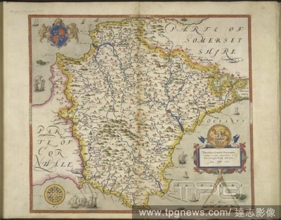
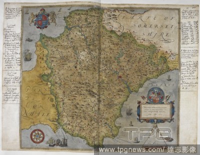
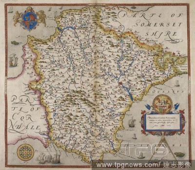
Editorial Somerset. An atlas of England and Wales, containing 35 colou. London, 1579. A map of Somerset. Image taken from An atlas of England and Wales, containing 35 coloured maps, drawn by Christopher Saxton and engraved by A. Ryther, R. Hogenberg, C. Hogius, ...
- 2018-12-06
- 1
Editorial Oxfordshire. C. Saxton's Atlas of England and Wales. [London], 1574. Oxonii buckinghami? et berceri? Comitatuum descriptio 1574.C. Saxton descripsit.. Image taken from C. Saxton's Atlas of England and Wales. Originally published/produced in 1574. Sou...
- 2018-12-06
- 1
Editorial Wiltshire. C. Saxton's Atlas of England and Wales. [London], 1576. Wiltoni? Comitatus hic ob oculos proponitur 1576.Christophorus Saxton descripsit. Image taken from C. Saxton's Atlas of England and Wales. Originally published/produced in 1576. Source...
- 2018-12-06
- 1

Editorial England and Wales. An atlas of England and Wales, containing 35 colou. London, 1579. A map of England and Wales. Image taken from An atlas of England and Wales, containing 35 coloured maps, drawn by Christopher Saxton and engraved by A. Ryther, R. Hoge...
- 2018-12-06
- 1
Editorial Essex. Essexi? Comitat. nova descriptio 1576.Christophorus Saxton descripsit. C. Saxton's Atlas of England and Wales. [London], 1576. Source: Maps.C.7.c.1, 12.
- 2018-12-06
- 1
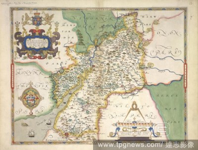
Editorial Gloucestershire. C. Saxton's Atlas of England and Wales. [London], 1577. Glocestri? sive Claudiocestri? Comitat' tipus at effigies 1577.Christophorus Saxton descripsit. Augustinus Ryther Anglus sculpsit. Image taken from C. Saxton's Atlas of England ...
- 2018-12-06
- 1
Editorial Dorsetshire. An atlas of England and Wales, containing 35 colou. London, 1579. A map of Dorset. Image taken from An atlas of England and Wales, containing 35 coloured maps, drawn by Christopher Saxton and engraved by A. Ryther, R. Hogenberg, C. Hogius,...
- 2018-12-06
- 1

Editorial Northamptonshire. C. Saxton's Atlas of England and Wales. [London], 1576. Northamton, Bedfordi?, Cantabrigi?, Huntingdoni? et Rutlandi? descriptio 1576.C. Saxton descripsit. Image taken from C. Saxton's Atlas of England and Wales. Originally publis...
- 2018-12-06
- 1

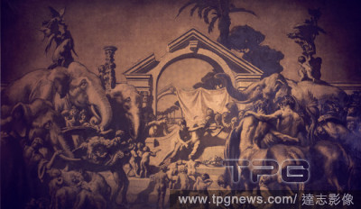
Editorial EL NI?O Y EL GALLO, EL TIO VIVO Y ALEGORIA DE LA FEMINEIDAD - 1918-1919 - COMEDOR DE SIR SAXTON NOBLE EN WRETHAM HALL, NORFOLK, INGLATERRA - 2,62x1,49.
- 2018-11-29
- 1

Editorial HUNG (2009). THOMAS JANE; SIANOA SMIT-MCPHEE; CHARLIE SAXTON.
- 2018-08-10
- 1

Editorial BANDSLAM (2009), directed by TODD GRAFF. VANESSA HUDGENS; ALY MICHALKA; RYAN DONOWHO; GAELAN CONNELL; CHARLIE SAXTON; TIM JO.
- 2018-08-10
- 6
Editorial [Group of 12 Stereograph Views of Celebrities, Including Popes and Presidents].
- 2018-08-09
- 1
Editorial EL NI?O Y EL GALLO, EL TIO VIVO Y ALEGORIA DE LA FEMINEIDAD - 1918-1919 - COMEDOR DE SIR SAXTON NOBLE EN WRETHAM HALL, NORFOLK, INGLATERRA - 2,62x1,49.
- 2018-07-20
- 1

Editorial TRIUNFO DE APOLO - 1913 - SALA DE LOS BUCRANEOS DE LA KENT HOUSE DE SIR SAXTON NOBLE EN LONDRES - GRISALLA EN NEGRO Y ORO SOBRE LIENZO 262 x 441 cm.
- 2018-07-19
- 1
 Loading