
filter
-
Brand
- By Category
- Direction
- Date Range
135Events
Pictures
Events

Editorial EXCLUSIVE: Genesis unveils the X Gran Berlinetta Vision Gran Turismo Concept car
- 2023-12-05
- 25
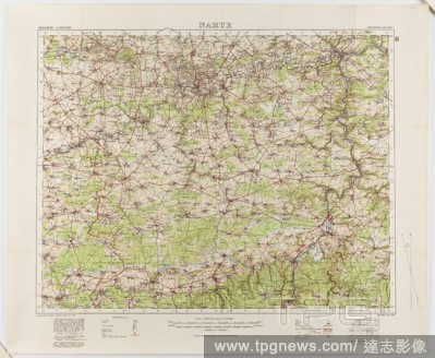
Editorial Map - Military, Belgium, Namur 8, General Staff no. 2364, Scale 1:100,000, World War I, 1910, Military map of Belgium, Namur area (a hand-written inscription identifies it as Namur 8 district), scale 1:100,000, published in 1910. The map is labelled Ge...
- 2020-01-15
- 1
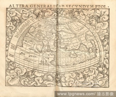
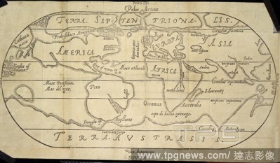
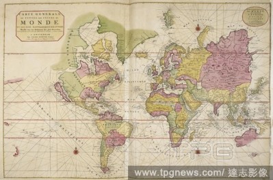
Editorial On the General tab. According PTOL., World map from the 16th century, Fig. 4, according to p. 2, 1552, Sebastian M?nster: Cosmographiae universalis Lib. VI. in quibus, iuxta certioris fidei scriptorum traditionem describuntur, Omniu[m] habitabilis orbi...
- 2020-01-15
- 1
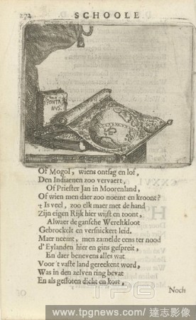
Editorial World map and books CXXVI. On seeing a World Map (title on object), A table with a world map and some books. Pent from a book in which 36 prints with phrases. Print used in: F. van Hoogstraten, The school of the world, 1682, map of the world, Arnold Ho...
- 2020-01-15
- 1

Editorial New World, Map of North America, Fig. 37, p. 161, Porro, Girolamo (ill.), 1575, Thomaso Porcacchi, Girolamo Porro: L' isole piu famose del mondo. Il secondo libro. In Venetia: apresso gli Heredi di Simon Galignani, 1590.
- 2020-01-15
- 1
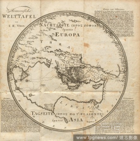
Editorial Homeric world table, World Map after Homer in Volume 2, Signed: Drawn by Hellwag., Engraved by F. Ramberg., Berlin, Fig. 1, Hellwag (del.); Ramberg, F. (sculp.), 1802, Johann Heinrich Voss: Homers Werke. K?nigsberg: Bei Friedrich Nicolovius, 1802.
- 2020-01-15
- 1
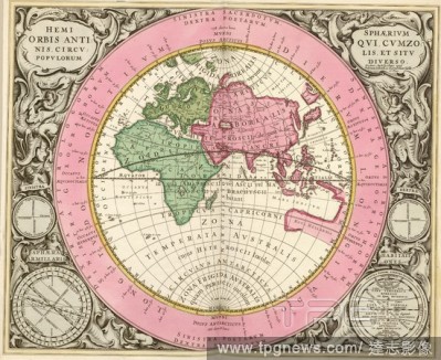
Editorial The ancient peoples of the hemisphere, the situation in different zones of the circles and, World map with astronomical data, pl. 13, p. 42, Cellarius, Andreas, Andreas Cellarius: Harmonia macrocosmica, seu, Atlas universalis et novus, totius universi ...
- 2020-01-15
- 1
Editorial Ptolemaic general panel, conceiving of the half andern weldt decryption., World map from the 16th century, Fig. 2, according to S. i, 1544, Sebastian M?nster: Cosmographia. Beschreibung aller Lender durch Sebastianum M?nsterum: in welcher begriffen all...
- 2020-01-15
- 1
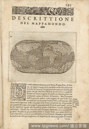
Editorial Descriptive of the World Map, World map, Fig. 45, p. 193, Porro, Girolamo (ill.), 1575, Thomaso Porcacchi, Girolamo Porro: L' isole piu famose del mondo. Il secondo libro. In Venetia: apresso gli Heredi di Simon Galignani, 1590.
- 2020-01-15
- 1
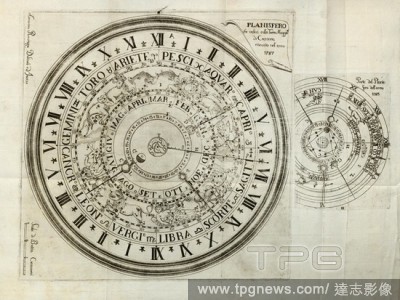
Editorial Planisphere that you see on the Maggio Tower of Cremona, renovated in the year 1787, Part of the World Map of the year 1585, Astronomical clock at Torrazzo di Cremona, signed: Amicino Ravizza delineo ed incise, Fig. 1, according to p. 18, Ravizza, Amic...
- 2020-01-15
- 1
Editorial On the World, World Type, Early modern world map, Fig. 1, p. 3, Gerhard Mercator, Jodocus Hondius, Jansson: Atlas minor Gerardi Mercatoris. Amsterodami: ex officina Ioannis Ianssonii, MDCXXXIIII [1634].
- 2020-01-15
- 1
Editorial Itinerarium. World map with costumes, natives, ships, plants and animals.
- 2020-01-15
- 1
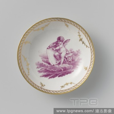
Editorial Saucer with a putto on clouds, Porcelain dish, painted on the glaze in pink (camaieu) and gold. On the shelf a putto with a world map on a cloud. On the card the inscription 'MARCKIES' [?]. The inner edge with a twisted band, on which garlands and flow...
- 2019-12-18
- 1

Editorial Cloth of linen printed with the world map and the signs of the zodiac, Cloth of linen printed with the world map and the signs of the zodiac., England, 1790 - 1800, linen (material), h 72.0 cm ? w 68.0 cm.
- 2019-12-18
- 1
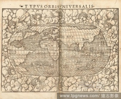
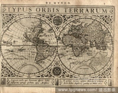
Editorial Typus Orbisuniversalis, World map from the 16th century, signed: KD, Fig. 3, according to p. 1, David Kandel, 1552, Sebastian M?nster: Cosmographiae universalis Lib. VI. in quibus, iuxta certioris fidei scriptorum traditionem describuntur, Omniu[m] hab...
- 2019-11-18
- 1
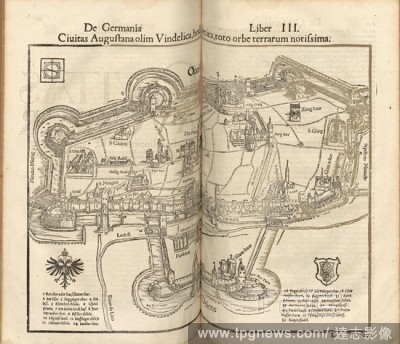
Editorial Once the city of Augusta Vindelica, today Rhetica, known all over the world, Map of Augusana from the 16th century, Fig. 52, after p. 610, 1552, Sebastian M?nster: Cosmographiae universalis Lib. VI. in quibus, iuxta certioris fidei scriptorum tradition...
- 2019-11-18
- 1

Editorial Cyrestis, Print, Cyrestis is a butterfly genus in the family Nymphalidae. They are known as map butterflies, so named because the wing-markings of some species resemble the lines of latitude and longitude of a world map. Cyrestis is a widespread genus ...
- 2019-11-18
- 1
Editorial Ptolemy World map.
- 2019-10-28
- 1
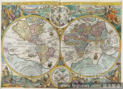
Editorial Theatrum Orbis Terrarum (Theatre of the World). Is considered to be the first true modern atlas. Written by Abraham Ortelius and originally printed on May 20, 1570, in Antwerp. World Map.
- 2019-08-02
- 1
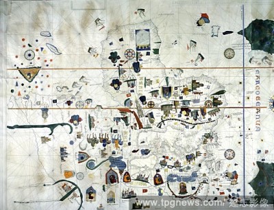
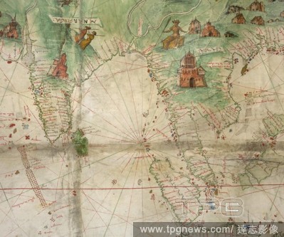
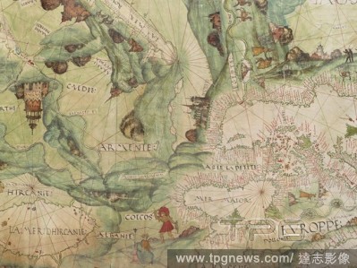
Editorial Europe, Asia and Africa from a world map by Juan de la Cosa. Juan de la Cosa (1460-1510, Spanish cartographer, conquistador and explorer) was member of seven voyages to the New World.
- 2019-08-02
- 3
Editorial World map. 1579. Madrid, Geographic department of the Army.
- 2019-08-02
- 1
Editorial Claudius Ptolemy (90-168) Greco-Egyptian geographer. World map. Engraving, 16th century.
- 2019-07-16
- 1

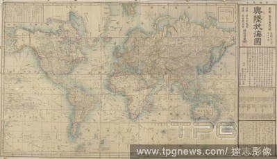
Editorial Japanese World Map by Japanese cartographer NagakunoSekisui (1717-1801) Revised map of all countries on the globe/ Map of the world and its mountains and oceans. 18th century.
- 2019-06-13
- 2

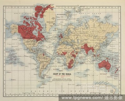
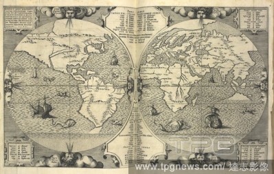
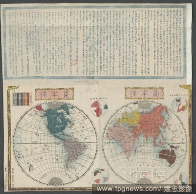
Editorial World map of the Geographical Distribution of the Races of Men. Arabian in pink, Malay in green, Abyssinian in yellow, Papuan in dark blue, Mongolian in beige, Negrillo in ochre, Hottentot in blue, Telingan in red, Nubian in steel blue; Australian in s...
- 2019-02-22
- 1

Editorial Japanese Buddhist world map. Kyoto, Obei Bundaiken, 1710. Outline map of all the countires in Jambu-dvipa. Woodcut. Originally published/produced in Kyoto, Obei Bundaiken, 1710. . Source: Maps.C.21.bb.8,.
- 2019-01-24
- 1
Editorial [Detail of map] India and the Bay of Bengal to the Malay Peninsula, Indonesia, and the South China Sea. Produced for the Dauphin [Henri II]. Dauphin Map [Harley World Map]. France; 1547. prester john,king, . Source: Add. 5413,. Language: French.
- 2019-01-24
- 1

Editorial Theatrum Orbis Terrarum (Theatre of the World). Is considered to be the first true modern atlas. Written by Abraham Ortelius and originally printed on May 20, 1570, in Antwerp. World Map.
- 2019-01-23
- 1

Editorial Nautical world map. (Australia is suggested but still unknown territory and, California is shown as an island).
- 2018-12-06
- 1
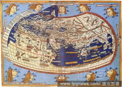
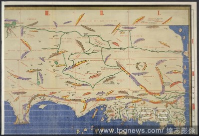
Editorial Ptolemy's World Map. Geographia. Greece [Monastery of Vatopedi, Mount Athos]; early. [Whole map] Map of the world; from the British Isles and Europe, the Mediterranean Sea and North Africa, to the Middle East, Arabia, and Asia Image taken from Geograp...
- 2018-12-06
- 1
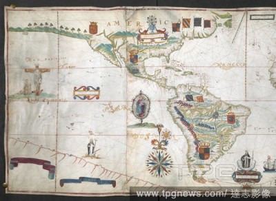
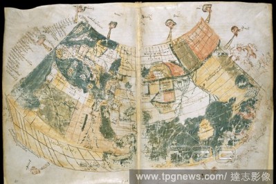
Editorial Left half of a world map, showing America. A map of the world drawn by Antonio Sances apparently for "Domingvos Martis Dorta;" 1623: with coloured drawings, coats of arms of various countries, etc. 1623. Total length of roll map : Vellum roll, 6 ft. 5 ...
- 2018-12-06
- 1
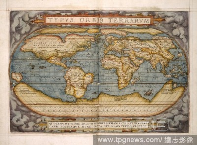
Editorial World map. Theatrum Orbis Terrarum. Antwerp, 1570. Source: Maps.C.2.c.3,.
- 2018-12-06
- 1
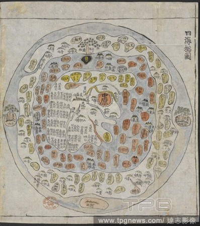
Editorial A Korean World Map. Chonhado/World Atlas. Korea, 19th Century. A Korean World Map, printed and hand-coloured, from an atlas of Korea with preliminary maps of the world, China, Japan and Ryuku islands. Image taken from Chonhado/World Atlas. Originally...
- 2018-12-06
- 1
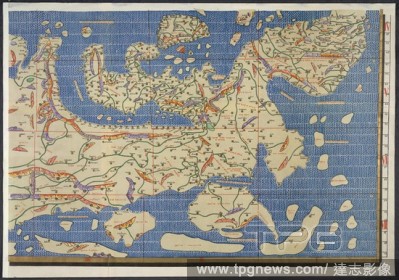
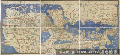
Editorial World map. Charta Rogeriana--Weltkarte des Idrisi--vom Jahr 1. Stuttgart, 1928. Section of Idrisi world map. Image taken from Charta Rogeriana--Weltkarte des Idrisi--vom Jahr 1154 n. Ch. Wiederhergestellt und herausgegeben von Konrad Miller. (Explanat...
- 2018-12-06
- 1

Editorial Ptolemic World Map. Beatissimo Patri Paulo Secundo Pontifici Maximo. D Donis Nicolaus. Ulm, 1482. Source: C.3.d.7,.
- 2018-12-06
- 1
Editorial World map. Charta Rogeriana--Weltkarte des Idrisi--vom Jahr 1. Stuttgart, 1928. Section of Idrisi world map. Image taken from Charta Rogeriana--Weltkarte des Idrisi--vom Jahr 1154 n. Ch. Wiederhergestellt und herausgegeben von Konrad Miller. (Explanat...
- 2018-12-06
- 1
Editorial World map. Our Empire Atlas showing British Possessions at home and abroad. Edinburgh; London : W. & A.K. Johnston, 1897. Source: Maps.19.b.21, 5. Language: English.
- 2018-12-06
- 1
Editorial World map. [A General Atlas of Modern Geography]. [Constantinople], [1867?]. Twin-hemisphere world map. Image taken from [A General Atlas of Modern Geography]. Originally published/produced in [Constantinople], [1867?]. . Source: Maps.42.d.1,.
- 2018-12-06
- 1
Editorial World Map. Le Théatre du Monde ou Nouvel Atlas. Amsterdam, 1638-1640. Blaeu's World Map, entitled America. Image taken from Le Théatre du Monde ou Nouvel Atlas. Originally published/produced in Amsterdam, 1638-1640. Source: Maps.4.Tab.8, 9, 1.
- 2018-12-06
- 1

Editorial Right half of a world map, showing Britain, Europe and Africa. A map of the world drawn by Antonio Sances apparently for "Domingvos Martis Dorta;" 1623: with coloured drawings, coats of arms of various countries, etc. 1623. Total length of roll map : V...
- 2018-12-06
- 1

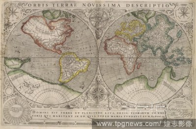
Editorial World Map. Gerardi Mercatoris Atlas, sive Cosmographicae Medi. Amsterdam: H. Hondius, 1633. World Map. Image taken from Gerardi Mercatoris Atlas, sive Cosmographicae Meditationes de fabrica Mundi et fabricati figura. [Edited by H. Hondius. Latin text]...
- 2018-12-06
- 1
Editorial World map. A True Discourse of the late voyages of discouerie. Henry Bynnyman: London, 1578. Source: G.6527,. Language: English.
- 2018-12-06
- 1
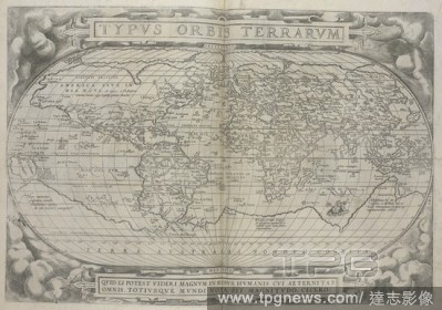
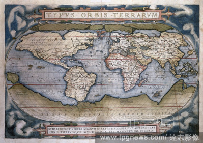
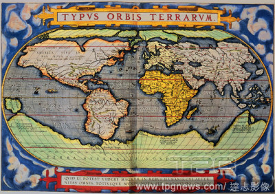
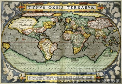
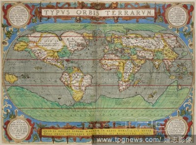
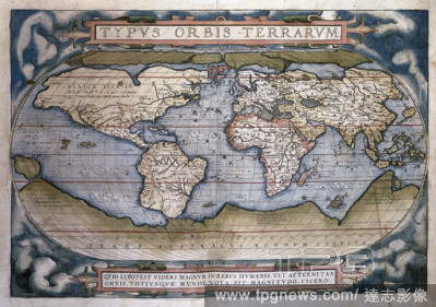
Editorial Typvs orbis terrarvm. 16th century world map by Ortelius. . Theatrvm Orbis Terrarvm. Anvers : De l'Imprimerie de Christofle Plantin, pour Abraham Ortel, autheur mesme de ce liure, 1587. Source: Maps.C.2.d.2 before page 2.
- 2018-12-06
- 1
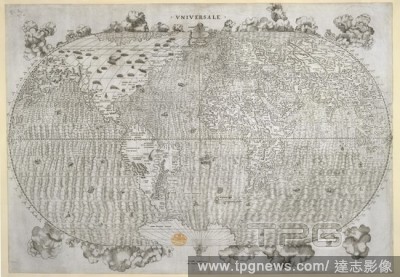
Editorial World map. Universale. [By] Giacomo [Gastaldo] Cosmographo. [. Venetia, 1546. World map. Image taken from Universale. [By] Giacomo [Gastaldo] Cosmographo. [On the elliptical projection].. Originally published/produced in Venetia, 1546. . Source: Maps...
- 2018-12-06
- 1
Editorial Detail of the city of Jerusalem. Dauphin Map [Harley World Map]. France; 1547. Source: Add. 5413. Language: French.
- 2018-12-06
- 1
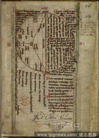
Editorial World map. Miscellaneous Writings. England [St Alban's Abbey and Wymondham]; between. [Whole folio] Circular world map, with Jerusalem in the centre. Signature of Sir Robert Cotton Image taken from Miscellaneous Writings. Originally published/produce...
- 2018-12-06
- 1
Editorial World Map. Typus Orbis Terrarum. Atlas Sive Cosmographica. Antwerp, 1598. Source: Maps.C.2.d.7, 1-2.
- 2018-12-06
- 1
Editorial A twin hemisphere world map. Source: Maps *920.(89).
- 2018-12-06
- 1
Editorial World map. [Map of the Ancient World.] Lithographed from an a. Ulmae : L. Hol., 1482. Map of the world. Image taken from [Map of the Ancient World.] Lithographed from an atlas to Ptolemy's Geography Rome, 1478. Originally published/produced in Ulmae ...
- 2018-12-06
- 1
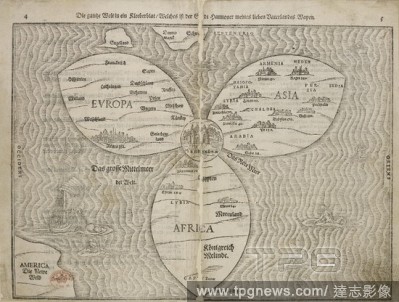
Editorial World map. Die gantze Welt in ein Kleeberblat welches ist der. Magdeburg, 1585. World map in the shape of a three-leaf clover. Image taken from Die gantze Welt in ein Kleeberblat welches ist der Stadt Hannover meines lieben Vaterlandes Wapen. ('The wh...
- 2018-12-06
- 1
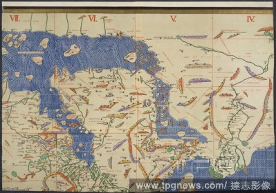
Editorial World map. Charta Rogeriana--Weltkarte des Idrisi--vom Jahr 1. Stuttgart, 1928. Section of Idrisi world map. Image taken from Charta Rogeriana--Weltkarte des Idrisi--vom Jahr 1154 n. Ch. Wiederhergestellt und herausgegeben von Konrad Miller. (Explanat...
- 2018-12-06
- 2
Editorial World map. Theatrum Orbis Terrarum. Antwerp, 1606. Typus Orbis Terrarum. Image taken from Theatrum Orbis Terrarum. Originally published/produced in Antwerp, 1606. . Source: Maps.9.Tab.8, 1.
- 2018-12-06
- 1

Editorial World Map. Eastern and Western hemispheres; Brazil shown as separate from the continent. Jean Rotz, Boke of Idrography (The 'Rotz Atlas'). 1542. Source: Royal 20 E. IX, ff.29v-30. Language: English.
- 2018-12-06
- 1
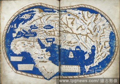
Editorial A world map, a chart of the globe, with the French royal arms. A 16th century work. This chart formerly belonged to Edward Harley, Earl of Oxford. Known as the ’Harfian’ or ’Dauphin’ Map. The ’Harfian’ or ’Dauphin’ Map. A large chart of...
- 2018-12-06
- 1

Editorial The Beatus world map, with Adam, Eve and the Serpent in the Garden of Eden at the top. The Mediterranean is represented as a blue line in the centre, the River Nile as its continuation bending to the right, and the Red Sea as a vertical red line. Two r...
- 2018-12-06
- 1
Editorial World map. [A General Map of the World on Mercator's projecti. [Yedo?], [1860?]. World map. Image taken from [A General Map of the World on Mercator's projection].. Originally published/produced in [Yedo?], [1860?]. . Source: Maps.920.(150),.
- 2018-12-06
- 1

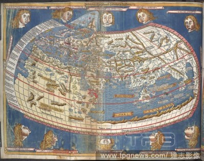
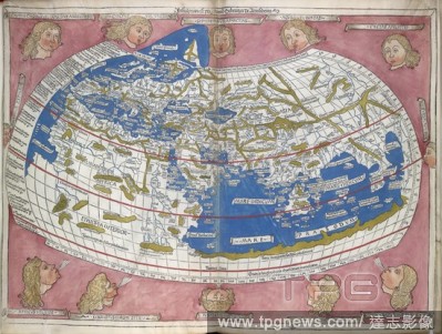
Editorial Ptolemic World Map. Geographia Latin. Beatissimo Patri Paulo Secundo P. Ulm, 1482. World Map by Ptolemy. Image taken from Geographia Latin. Beatissimo Patri Paulo Secundo Pontifici. Originally published/produced in Ulm, 1482. . Source: IC.9303,.
- 2018-12-06
- 2
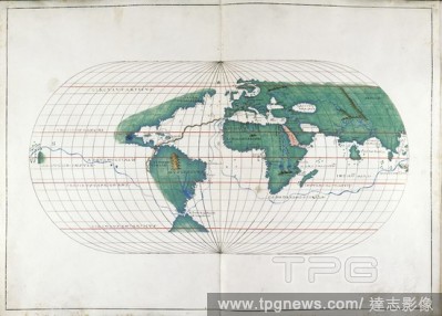
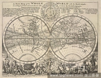
Editorial A world map on which are marked the hours and minutes of the true times of Venus's orbit around the Sun. Mappemonde, sur laquelle on a marque? les heures et les minutes du tems vrai de l'entre?e et de la sortie du centre de Venus sur le disque du Sol...
- 2018-12-06
- 1

Editorial Java and Sumatra. Dauphin Map [Harley World Map]. France; 1547. [Detail of map] Detail from bottom of map, showing Java La Grande, and islands to the north, including Sumatra. Produced for the Dauphin [Henri II] Image taken from Dauphin Map [Harley Wo...
- 2018-12-06
- 1
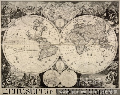
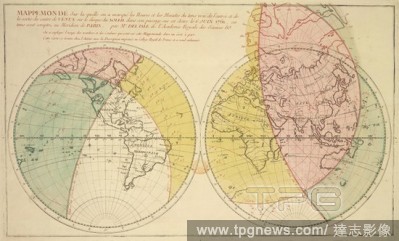
Editorial A twin hemisphere world map. Mappe Monde nouvelle. 1744. Source: Maps K.Top.4.26.
- 2018-12-06
- 1
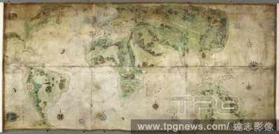
Editorial World Map. Portolan Atlas. Italy [Venice]; 1536. [Whole map] Map of the world showing the route of Magellan's circumnavigation and route from Polosi to Seville [1519-1522] Image taken from Portolan Atlas. Originally published/produced in Italy [Venic...
- 2018-12-06
- 1
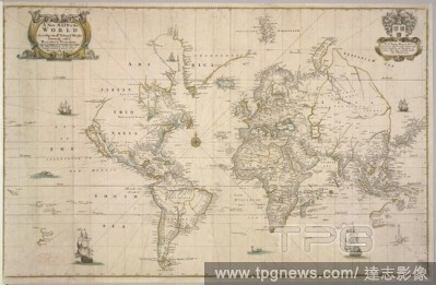
Editorial World map. A new Mapp of the World according to Edward Wright. [London], [1704?]. Source: Maps.C.27.d.10,. Language: English.
- 2018-12-06
- 1
Editorial World map. El Idrisi map (1154): reconstruction by Konrad Mil. Stuttgart, 1928. World Map. Image taken from El Idrisi map (1154): reconstruction by Konrad Miller. Charta Rogeriana--Weltkarte des Idrisi--vom Jahr 1154 n. Ch. Wiederhergestellt und herau...
- 2018-12-06
- 1

Editorial Detail of the city of Quinsay. Dauphin Map [Harley World Map]. France; 1547. Source: Add. 5413. Language: French.
- 2018-12-06
- 1
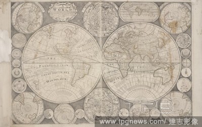
Editorial Twin-hemisphere world map. Atlas Minor: or a set of sixty-two new and correct. London : Printed for Thomas Bowles ... and John Bo. Source: Maps.C.39.b.4, 1.
- 2018-12-06
- 1
Editorial Ptolemic World Map. Geographia Latin. Beatissimo Patri Paulo Secumdo P. Ulm, 1482. World Map by Ptolemy. Image taken from Geographia Latin. Beatissimo Patri Paulo Secumdo Pontifici Maximo. Originally published/produced in Ulm, 1482 . Source: IC.9304,.
- 2018-12-06
- 1
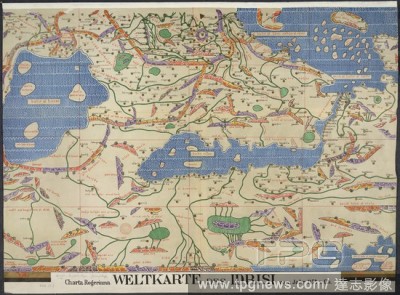
Editorial World map. Charta Rogeriana--Weltkarte des Idrisi--vom Jahr 1. Stuttgart, 1928. Section of Idrisi world map. Image taken from Charta Rogeriana--Weltkarte des Idrisi--vom Jahr 1154 n. Ch. Wiederhergestellt und herausgegeben von Konrad Miller. (Explanat...
- 2018-12-06
- 1
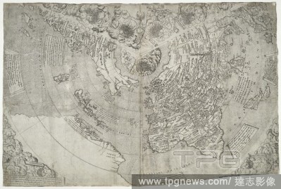
Editorial World map by Martellus, including the Cape of Good Hope, rounded by Bartolomeo Dias in 1488. Account of the Islands of the Mediterranean. Florence, 1489. Source: Add. 15760, ff.68v-69. Language: Latin.
- 2018-12-06
- 1
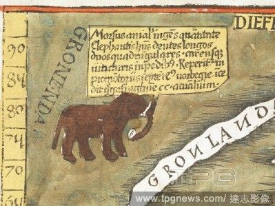
Editorial A detail of an elephant-like walrus on the first modern world map. Claudii Ptolemaei Geographicae enarrationis libri octo Bilibaldo Pirckeymhero interprete. Annotationes Joannis de Regio Monte in errores commissos a Jacobo Angelo in translatione sua. [...
- 2018-12-06
- 1
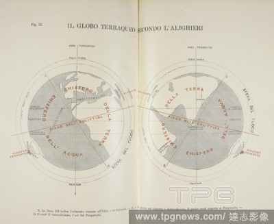
Editorial A twin hemisphere world map. Il Paradiso terrestre dantesco, etc. Firenze, 1897. Source: Ac.8848, between pages 196-197.
- 2018-12-06
- 1
Editorial World map of R. Higden. World Map in rounded oval shape. The heads placed round the edge represent the twelve winds. Britain is at the lower left. Polychronicon. Late 14th century. Source: Royal 14 C. IX, ff.1v-2.
- 2018-12-06
- 1

Editorial Drawing of the Hereford World Map in its original frame, with folding doors, and decorated with painted figures. At the top of the map is a Day of Judgement scene. Sketches relating to the Antiquities and Architectecture of England, Vol. XVIII. England...
- 2018-12-06
- 1
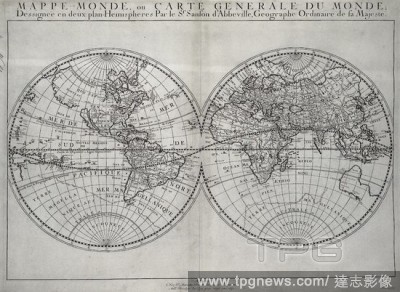
Editorial A twin hemisphere world map. Mappe-Monde, ou Carte ge?ne?rale du Monde dessigne?e en deux plan-he?misphe?res. 1651. Source: Maps K.Top.4.8. Language: French.
- 2018-12-06
- 1
Editorial World Map. (Map of the World). 1506. Source: Maps.C.2.cc.4.
- 2018-12-06
- 1
Editorial The Tiberius Map. Mappa Mundi; only surviving world map from Anglo-Saxon England. It is divided into the three continents of Europe, Asia and Africa, with the Mediterranean Sea in the centre.The outline and detail of the British Isles are relatively ac...
- 2018-12-06
- 1
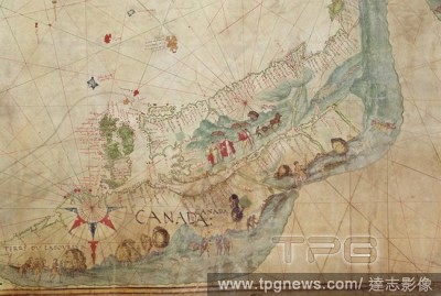
Editorial Detail showing Jacques Cartier and his followers in Canada. Dauphin Map [Harley World Map]. France; 1547. Source: Add. 5413. Language: French.
- 2018-12-06
- 1
Editorial World map. Liber Ieremi? siue de actione. In: Bible. [Polyglott.] Biblia sacra, Hebraice, Chaldaice, Gr?ce & Latine. tom 8. [1569, etc.]. Antverpi? : C. Plantin, 1569 [1571]-73. Belgium Antwerp. Source: 6.h.11.(5). Language: Latin.
- 2018-12-06
- 2

Editorial World map. Vertoning van de merkwaardige Zons-verduistering o. Amsterdam, [1733?]. Twin-hemisphere world map. Image taken from Vertoning van de merkwaardige Zons-verduistering ofte groote Zon-Eclips die wezen zal den 13 Mey, 1733, hoe deselve zig bove...
- 2018-12-06
- 1
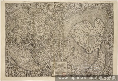
Editorial World map. Nova, et integra Universi Orbis Descriptio. From:. Paris, Apud Joannem Parvum, 1532. Source: Maps.920.(39),.
- 2018-12-06
- 1
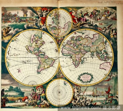
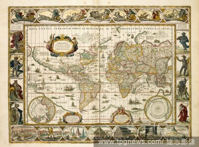
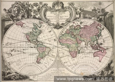
Editorial World Map. Nova Totius Terrarum Orbis. Amsterdam, 1668. Four Hemisphere World Map. Borders decorated with landscapes representing the four elements, with scenes taken from The Iliad. Image taken from Nova Totius Terrarum Orbis. Originally published/p...
- 2018-12-06
- 1
Editorial A world map. Twelve plates of national flags. Source: Maps 147.d.26, page 1. Language: French.
- 2018-12-06
- 1
Editorial World map. A new and correct Map of the World. Laid down acco. London : R. Marshall, 1785. Source: Maps.M.T.11.g.1.(9),. Language: English.
- 2018-12-06
- 1

Editorial World map. Noua orbis terrarum delineatio singulari ratione a. Ulm, 1627. Map of the world. Image taken from Noua orbis terrarum delineatio singulari ratione accommodata meridiano Tabb. 680 x 385 mm. fol. . Originally published/produced in Ulm, 1627....
- 2018-12-06
- 1
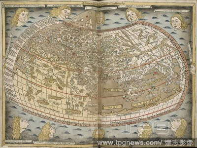
Editorial Ptolemy's World Map. [Map of the Ancient World.] Lithographed from an a. Ulm, 1482. Ptolemy's World Map. Image taken from [Map of the Ancient World.] Lithographed from an atlas to Ptolemy's Geography . Originally published/produced in Ulm, 1482. . So...
- 2018-12-06
- 1
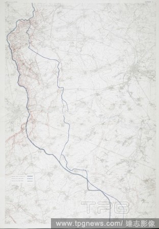
Editorial First World Map covering Loos; Givenchy; Vimy; Boclincourt; Arras; Bullecourt; Doignes; Demicourt and Hermies. Stamped '25 May 1917'. [Map of Arras District. Special Trench Maps.]. 710 x 1040 mm.; Scale 1: 40 000. Source: Maps.c.14.f.31.
- 2018-12-06
- 1
Editorial World map. Charta Rogeriana--Weltkarte des Idrisi--vom Jahr 1. Stuttgart, 1928. Section of Idrisi world map. Image taken from Charta Rogeriana--Weltkarte des Idrisi--vom Jahr 1154 n. Ch. Wiederhergestellt und herausgegeben von Konrad Miller. (Explanat...
- 2018-12-06
- 1

Editorial Typus Orbis Terrarum. Typus Orbis Terrarvm. Franciscus Hogenbergus sculp. Antverpiae : Apud AEgid. Coppenium Diesth, XX. Mai. World map. Image taken from Typus Orbis Terrarvm. Franciscus Hogenbergus sculpsit. [On the elliptical projection]. 495 x 340 ...
- 2018-12-06
- 1

Editorial Japanese Buddhist world map. Kyoto, Obei Bundaiken, 1710. Outline map of all the countires in Jambu-dvipa. Woodcut. Originally published/produced in Kyoto, Obei Bundaiken, 1710. . Source: Maps.C.21.bb.8,.
- 2018-12-06
- 1
Editorial World map. [A Map of the World. On the stereographic projecti. Yedo, [1848?]. A map of the world. Image taken from [A Map of the World. On the stereographic projection].. Originally published/produced in Yedo, [1848?]. . Source: Maps.920.(118),.
- 2018-12-06
- 1

Editorial [Detail of map] India and the Bay of Bengal to the Malay Peninsula, Indonesia, and the South China Sea. Produced for the Dauphin [Henri II]. Dauphin Map [Harley World Map]. France; 1547. prester john,king, . Source: Add. 5413,. Language: French.
- 2018-12-06
- 1

Editorial Ptolemic World Map. [Map of the Ancient World.] Lithographed from an a. Strasbourg, 1513. World Map by Ptolemy. Image taken from [Map of the Ancient World.] Lithographed from an atlas to Ptolemy's Geography. Originally published/produced in Strasbour...
- 2018-12-06
- 1
Editorial World map. A Collection of ninety-five Maps, chiefly French,. Paris, 1630-1690. Source: Maps.C.39.e.6, 3. Language: Latin.
- 2018-12-06
- 1
Editorial World map. D. Domino Leonardo ab Eck ... P. Apianus ... Mathe. [Ingoldstadt], 1530. World map. Image taken from D. Domino Leonardo ab Eck P. Apianus Mathematicus hanc universaliorem cogniti orbis tabulam ex recentibus observationibus confectam dedicat...
- 2018-12-06
- 1

Editorial A world map, a chart of the globe, with the French royal arms. A 16th century work. This chart formerly belonged to Edward Harley, Earl of Oxford. Known as the 'Harfian' or 'Dauphin' Map.
- 2018-12-06
- 1
Editorial Theatrum Orbis Terrarum (Theatre of the World). Is considered to be the first true modern atlas. Written by Abraham Ortelius and originally printed on May 20, 1570, in Antwerp. World Map.
- 2018-10-11
- 1
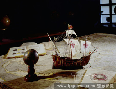
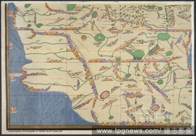
Editorial World map and globe, 1507 by Martin Waldseemueller, and a scale model of Christopher Columbus' flagship, the " Santa Maria" .
- 2018-10-11
- 1
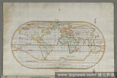
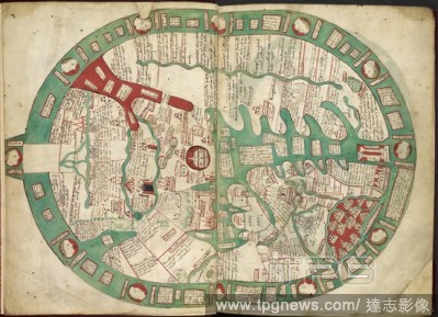
Editorial Oval World Map. Date/Period: Ottoman. Illuminated manuscripts; folios (leaves); maps. Ink and pigments on laid European paper ink and pigments on laid European paper. Height: 34 mm (1.33 in); Width: 24 mm (0.94 in).
- 2018-10-11
- 2

Editorial Europe, Asia and Africa from a world map by Juan de la Cosa. Juan de la Cosa (1460-1510, Spanish cartographer, conquistador and explorer) was member of seven voyages to the New World.
- 2018-10-11
- 3

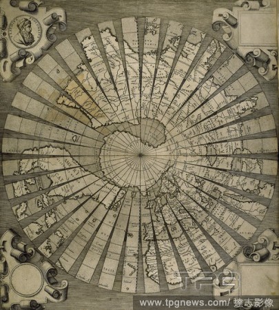
Editorial World map. South Pole. Map by Antonius Florianus. Engraving by 16th century.
- 2018-10-11
- 3

Editorial Portrait of Juan de la Cosa (c.1460-1510), Spanish cartographer, conquistador and explore who made the earliest extant European world map to incorporate the territories of the Americas that were discovered in the 15th century.. Madrid.
- 2018-10-11
- 1

Editorial World map. 1579. Madrid, Geographic department of the Army.
- 2018-10-11
- 1
 Loading