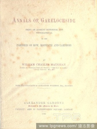
EditorialAnnals of Garelochside, being an account historical and topographical of the parishes of Row, Rosneath and Cardross : Maughan, William Charles, d. 1914.
EditorialAmbroise Tardieu, French, 1788-1841, Model for the Uniform of the National Guard of the Rural Parishes, 1817, sight measurement: 10 3/8 x 15 5/8 in.
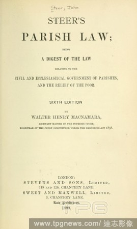
EditorialSteer's Parish law; being a digest of the law relating to the civil and ecclesiastical government of parishes, and the relief of the poor : Steer, John.
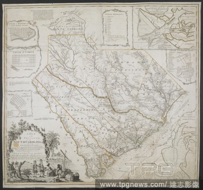
EditorialA Map of the Province of South Carolina. A MAP of the PROVINCE of SOUTH CAROLINA with all the Rivers, Creeks, Bays, Inletts, Islands, INLAND NAVIGATION, Soundings, Time of High Water on the Sea Coast, Roads, Marshes, Ferrys, Bridges, Swamps, Parishes C...
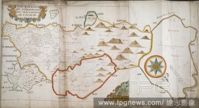
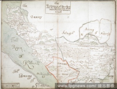
EditorialThe Barronie of Tullaghagh in the County of Cavan [Ulster] by [surveyor's name not given]'; [1657-1659?]. Scale: 160 perches to an inch [1:31680]. South west at top. Showing boundaries of parishes (in colour) and townlands, with place-names. Rivers and...
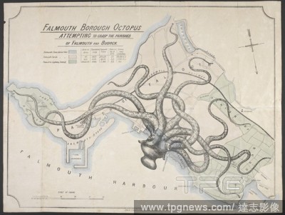
EditorialFalmouth borough octopus attempting to grasp the parishes of Falmouth and Budock. Political map of Falmouth. An octopus is superimposed over a plan of the area, denoting perceived attempts at expansion by Falmouth borough (essentially the town) and the...
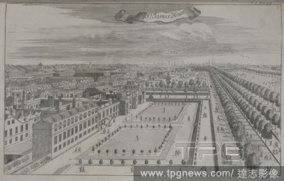
EditorialThe hospitall at Greenwich. [An Atlas of London, containing a general map and thirty-six maps of the Wards, Parishes and Liberties, with twentyfive views of the principal institutions and buildings. Based upon an earlier survey by William Leybourn and ...
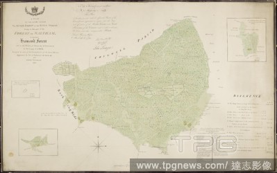
EditorialA plan of the lands called the King's Forest, or the King's Woods, lying in that part of the forest of Waltham called Hainault Forest, and in the parishes of Barking and Dagenham. A colored plan of the lands called the King's Forest, or the King's Wood...
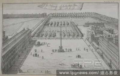
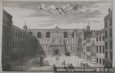
EditorialThe prospect of Lincoln's inn. [An Atlas of London, containing a general map and thirty-six maps of the Wards, Parishes and Liberties, with twentyfive views of the principal institutions and buildings. Based upon an earlier survey by William Leybourn a...
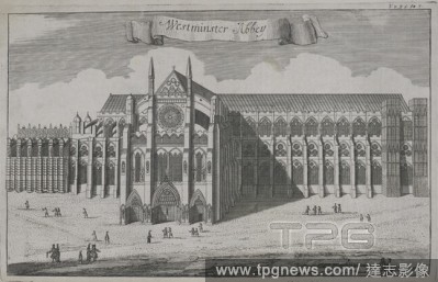
EditorialWestminster Abbey. [An Atlas of London, containing a general map and thirty-six maps of the Wards, Parishes and Liberties, with twentyfive views of the principal institutions and buildings. Based upon an earlier survey by William Leybourn and Richard B...
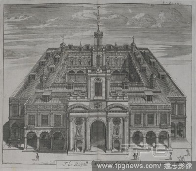
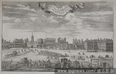
EditorialThe Royall exchange of London. [An Atlas of London, containing a general map and thirty-six maps of the Wards, Parishes and Liberties, with twentyfive views of the principal institutions and buildings. Based upon an earlier survey by William Leybourn a...
EditorialThe Barronny of Dunkerron', co. Kerry (Munster), by an unidentified surveyor; [1655-1656?]. No compass points, but west approx. at top. Scale bar: 320 perches to the inch [1:63360]. Showing, rather crudely, boundaries of parishes and townlands, with pl...
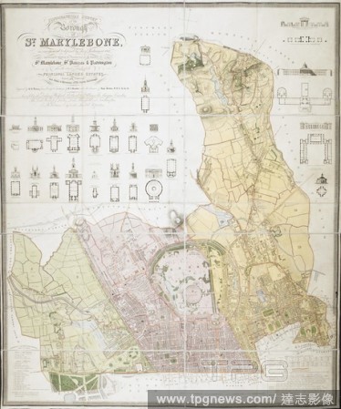
EditorialTopographical survey of the borough of St. Marylebone, as incorporated & defined by Act of Parliament 1832. : Embracing & marking the boundaries of the parishes of St. Marylebone, St. Pancras, & Paddington, also the extents & limits of the principal la...
EditorialA plan of the Cities of London and Westminster. Milne's Plan of the Cities of London and Westminster, circumjacent Towns and Parishes, ... laid down from a trigonometrical survey taken in the years 1795-1799. 1800. Source: Maps K.Top.6.95. Language: En...
EditorialThe prospect of Guildhall. [An Atlas of London, containing a general map and thirty-six maps of the Wards, Parishes and Liberties, with twentyfive views of the principal institutions and buildings. Based upon an earlier survey by William Leybourn and R...
EditorialSt. James House. [An Atlas of London, containing a general map and thirty-six maps of the Wards, Parishes and Liberties, with twentyfive views of the principal institutions and buildings. Based upon an earlier survey by William Leybourn and Richard Blo...
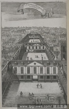
EditorialSt. Thomas hospitall at Southwark. [An Atlas of London, containing a general map and thirty-six maps of the Wards, Parishes and Liberties, with twentyfive views of the principal institutions and buildings. Based upon an earlier survey by William Leybou...
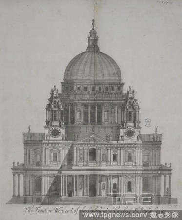
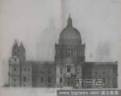
EditorialThe front or west end of the cathedral church of St. Paul's, London. [An Atlas of London, containing a general map and thirty-six maps of the Wards, Parishes and Liberties, with twentyfive views of the principal institutions and buildings. Based upon a...
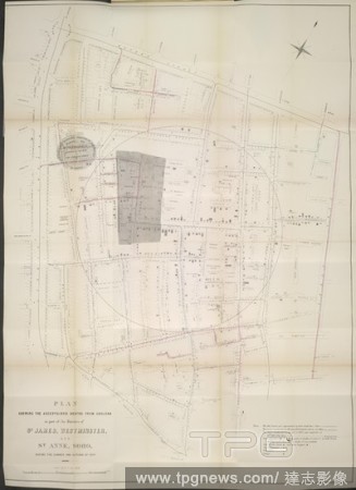
Editorial'Plan shewing the ascertained deaths from cholera in part of the parishes of St James, Westminster, and st Anne, Soho, during the summer and autumn of 1854. . Report of the Cholera Outbreak in the Parish of St. James, Westminster during the Autumn of 1...
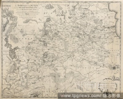
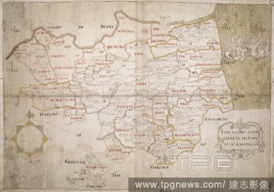
EditorialA map of the Diocese of Meath, comprising Meath, Westmeath, and a great part of the King's County. The Diocese of Meath, comprising Meath, Westmeath, & a great part of the King's County &c. &c. divided into Baronies and Parishes ... to which is added a...
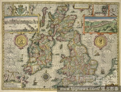
EditorialA map of Great Britain and Ireland. The Kingdome of England. Described by Christopher Saxton, augmented by John Speed ... Jodocus Hondius Flander caelavit ... 1610. (A Catalogue of all the Shires, Cities, Bishoprickes, Market-Townes, Castles, Parishes,...
EditorialThe south side of St. Paul's London cathedral. [An Atlas of London, containing a general map and thirty-six maps of the Wards, Parishes and Liberties, with twentyfive views of the principal institutions and buildings. Based upon an earlier survey by Wi...
EditorialThe Barony of Loghtee', co. Cavan (Ulster), surveyed by John Humfry (Humfrey); 1659. Scale: 320 perches to the inch [1:63360]. North east at top. Showing boundaries of parishes (in colour), with place-names. Areas of bog are indicated; a few buildings ...
EditorialSomerset house. [An Atlas of London, containing a general map and thirty-six maps of the Wards, Parishes and Liberties, with twentyfive views of the principal institutions and buildings. Based upon an earlier survey by William Leybourn and Richard Blom...
EditorialThe barony of Carbury, co. Cork (Munster), by an unidentified surveyor; [1655-1656?]. No scale indicated. North north west at top. Showing boundaries (in colour) and names of parishes, and townland boundaries. Sea coast, rivers and areas of bog are ind...
EditorialThe Barronny of Iveragh', co. Kerry (Munster), by an unidentified surveyor; [1655-1656?]. North west at top. Scale: 320 perches to the inch [1:63360]. Showing boundaries of parishes (in colour) and townlands, with place-names. Rivers and areas of bog a...
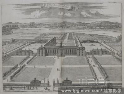
EditorialChelsey college. [An Atlas of London, containing a general map and thirty-six maps of the Wards, Parishes and Liberties, with twentyfive views of the principal institutions and buildings. Based upon an earlier survey by William Leybourn and Richard Blo...
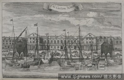
EditorialThe custom house. [An Atlas of London, containing a general map and thirty-six maps of the Wards, Parishes and Liberties, with twentyfive views of the principal institutions and buildings. Based upon an earlier survey by William Leybourn and Richard Bl...
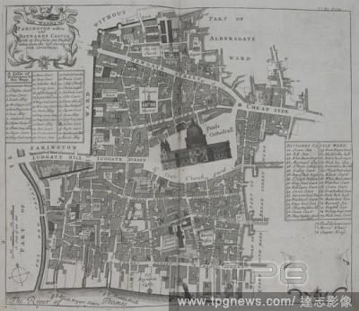
EditorialThe wards of Farington within and Barnard castle. [An Atlas of London, containing a general map and thirty-six maps of the Wards, Parishes and Liberties, with twentyfive views of the principal institutions and buildings. Based upon an earlier survey by...
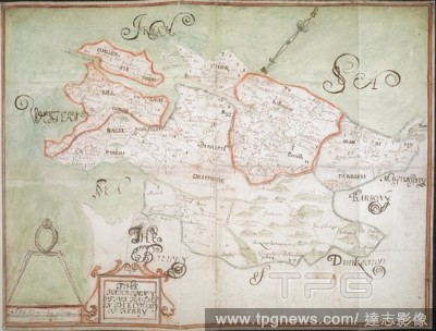
EditorialThe Barony of Duleeke in the County of East Meath [Leinster] Described', by an unidentified surveyor; [1655-1656?]. No scale given. North at top. Showing boundaries of parishes (in colour) and townlands, with place-names. Rivers, areas of bog and the s...
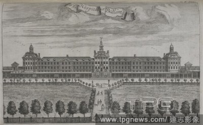
EditorialHospitall called Bedlam. [An Atlas of London, containing a general map and thirty-six maps of the Wards, Parishes and Liberties, with twentyfive views of the principal institutions and buildings. Based upon an earlier survey by William Leybourn and Ric...
EditorialThe prospect of Whitehall from the park of St. James. [An Atlas of London, containing a general map and thirty-six maps of the Wards, Parishes and Liberties, with twentyfive views of the principal institutions and buildings. Based upon an earlier surve...
EditorialTh east end of the Cathedral church of St. Pauls church. [An Atlas of London, containing a general map and thirty-six maps of the Wards, Parishes and Liberties, with twentyfive views of the principal institutions and buildings. Based upon an earlier su...
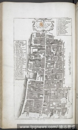
EditorialQueen Hith Ward and Vintry Ward, with their division into parishes. A survey of the cities of London and Westminster : containing the original, antiquity, increase, modern estate and government of those cities. London ; 1720. Source: 1791.d.5, opposite...
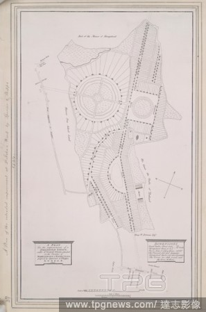
EditorialA plan for the improvement of a freehold estate, called St. John's Wood, situated in the parishes of Marylebone & Hampstead. 1794. Source: Maps.Crace.14.37. Language: English.


 Loading