
filter
-
Brand
- By Category
- Direction
- Date Range
66Events
Pictures
Events

Editorial The New Bonnet.
- 2020-03-02
- 1

Editorial The Nantucket School of Philosophy, After Eastman Johnson (American, 1824-1906), 1894, ink on paper, 5 x 7-1/8 in. (image) 9 x 10⁻³/4 in. (sheet).
- 2020-01-15
- 1
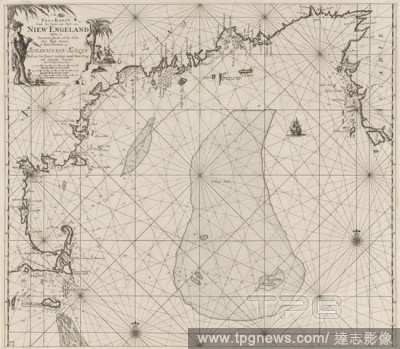
Editorial Passport card of part of the east coast of the United States and Canada Passport card of the sea coasts in the boght of New England between the Staaten Hoek and C. de Sable ), Passport card of a part of the east coast of the United States and Canada, b...
- 2019-12-18
- 1

Editorial The Lonely Farm, Nantucket. George Inness; American, 1825-1894. Date: 1892. Dimensions: 78.1 ? 116.2 cm (30 3/4 ? 45 3/4 in.). Oil on canvas. Origin: United States.
- 2019-12-17
- 1

Editorial Husking Bee, Island of Nantucket. Eastman Johnson; American, 1824-1906. Date: 1876. Dimensions: 69.3 ? 137 cm (27 1/4 ? 54 3/16 in.). Oil on canvas. Origin: Nantucket Island.
- 2019-12-17
- 1
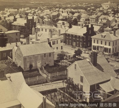
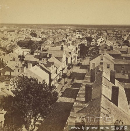
Editorial Nantucket, Massachusetts. Taken from Unitarian Church tower looking North West, Josiah Freeman (American, active 1860s - 1870s), about 1870, Albumen silver print.
- 2019-11-19
- 1
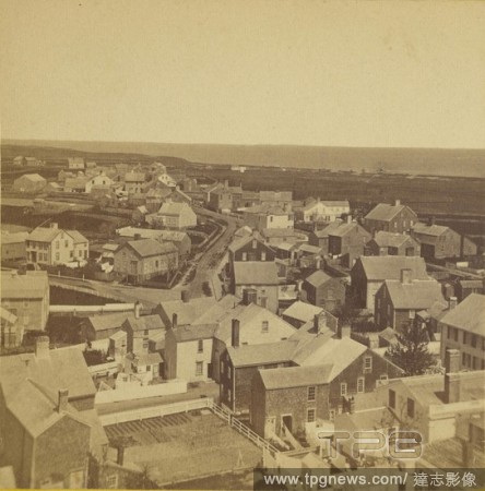
Editorial View of Nantucket, Mass., Josiah Freeman (American, active 1860s - 1870s), about 1870?1875, Albumen silver print.
- 2019-11-19
- 1
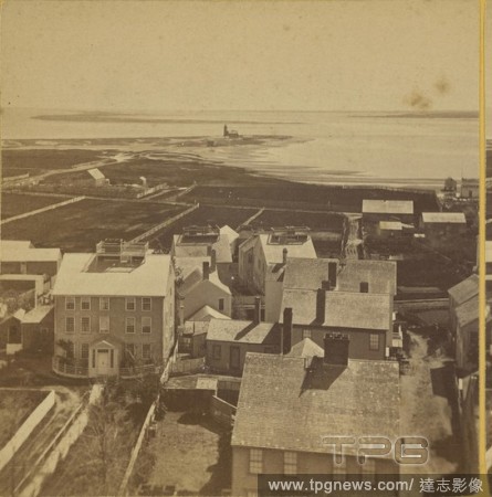
Editorial View of Nantucket, Mass., Josiah Freeman (American, active 1860s - 1870s), about 1870, Albumen silver print.
- 2019-11-19
- 1

Editorial The Hermit of Nantucket., Benjamin West Kilburn (American, 1827 - 1909), about 1865, Albumen silver print.
- 2019-11-19
- 1

Editorial Oldest House in Nantucket - built in 1686., Benjamin West Kilburn (American, 1827 - 1909), about 1875, Albumen silver print.
- 2019-11-19
- 1
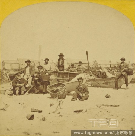
Editorial Fisherman of Seasconset, Nantucket., Benjamin West Kilburn (American, 1827 - 1909), about 1870, Albumen silver print.
- 2019-11-19
- 1
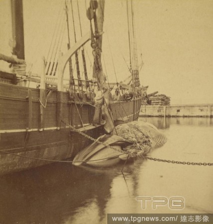
Editorial Taking a fin off a blackfish in harbor off ship, Nantucket, Mass., Josiah Freeman (American, active 1860s - 1870s), August 13, 1874, Albumen silver print.
- 2019-11-19
- 1
Editorial Nantucket, Massachusetts, Aug. 13, 1874, Josiah Freeman (American, active 1860s - 1870s), August 13, 1874, Albumen silver print.
- 2019-11-19
- 1

Editorial The Lonely Farm, Nantucket. George Inness; American, 1825-1894. Date: 1892. Dimensions: 78.1 ? 116.2 cm (30 3/4 ? 45 3/4 in.). Oil on canvas. Origin: United States.
- 2019-11-19
- 1

Editorial Husking Bee, Island of Nantucket. Eastman Johnson; American, 1824-1906. Date: 1876. Dimensions: 69.3 ? 137 cm (27 1/4 ? 54 3/16 in.). Oil on canvas. Origin: Nantucket Island.
- 2019-11-19
- 1

Editorial Nantucket School of Philosophy, Henry Wolf (American, 1852-1916), 1894, ink on paper, 5 x 7-1/16 in. (image) 8 x 10 in. (sheet), Signed in pencil, below image, lower right: Henry Wolf sculpt.
- 2019-11-18
- 1

Editorial Winding Yarn (Interior of a Nantucket Kitchen), 1872. Eastman Johnson (American, 1824-1906). Oil on board; framed: 70.2 x 85.4 x 10.2 cm (27 5/8 x 33 5/8 x 4 in.); unframed: 37.5 x 54.6 cm (14 3/4 x 21 1/2 in.); former: 52.7 x 69.9 x 5.1 cm (20 3/4 x 2...
- 2019-04-01
- 1

Editorial Spoon. Benjamin Bunker; American, 1751-1842; Nantucket, Massachusetts. Date: 1800. Dimensions: 22 ? 4.3 cm (8 5/16 ? 1 11/16 in.). Silver. Origin: Nantucket Island.
- 2019-04-01
- 1

Editorial The Lonely Farm, Nantucket. George Inness; American, 1825-1894. Date: 1892. Dimensions: 78.1 ? 116.2 cm (30 3/4 ? 45 3/4 in.). Oil on canvas. Origin: United States.
- 2019-03-18
- 1
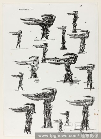
Editorial First Sketchs for Whaler of Nantucket. Theodore Roszak; American, born Poland, 1907-1981. Date: 1948-1949. Dimensions: 354 x 253 mm. Pen and black ink on ivory wove paper. Origin: United States.
- 2019-03-18
- 1

Editorial Studies for Whaler of Nantucket. Theodore Roszak; American, born Poland, 1907-1981. Date: 1949. Dimensions: 223 x 158 mm. Pen and black ink, with white gouache, on white wove paper. Origin: United States.
- 2019-03-18
- 1

Editorial Husking Bee, Island of Nantucket. Eastman Johnson; American, 1824-1906. Date: 1876. Dimensions: 69.3 ? 137 cm (27 1/4 ? 54 3/16 in.). Oil on canvas. Origin: Nantucket Island.
- 2019-03-18
- 1

Editorial Spoon. Benjamin Bunker; American, 1751-1842; Nantucket, Massachusetts. Date: 1800. Dimensions: 22 ? 4.3 cm (8 5/16 ? 1 11/16 in.). Silver. Origin: Nantucket Island.
- 2019-03-11
- 1

Editorial Ladle. James Easton; American, 1807-1903; Nantucket, Massachusetts. Date: 1825-1830. Dimensions: 31.8 ? 11.4 cm (12 1/2 ? 4 1/2 in.). Silver. Origin: United States.
- 2019-03-11
- 1

Editorial Lambs, Nantucket. Dated: 1874. Dimensions: overall: 48.26 ? 39.69 cm (19 ? 15 5/8 in.) framed: 63.18 ? 54.93 ? 5.24 cm (24 7/8 ? 21 5/8 ? 2 1/16 in.). Medium: oil on board.
- 2019-02-01
- 1

Editorial The New Bonnet.
- 2019-02-01
- 1

Editorial 1853, U.S. Coast Survey Nautical Chart or Map of Nantucket, Massachusetts.
- 2019-01-23
- 1
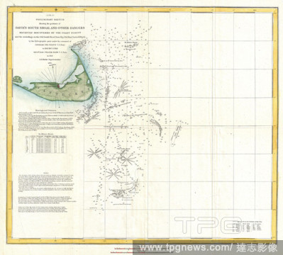
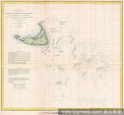
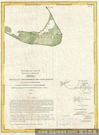
Editorial 1849, U.S. Coast Survey Map of Nantucket and the Davis Shoals.
- 2019-01-23
- 1

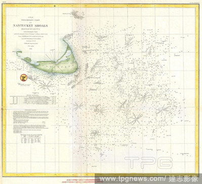
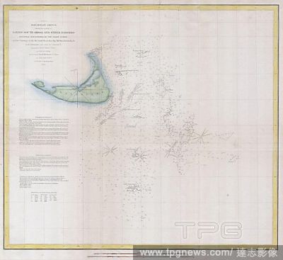
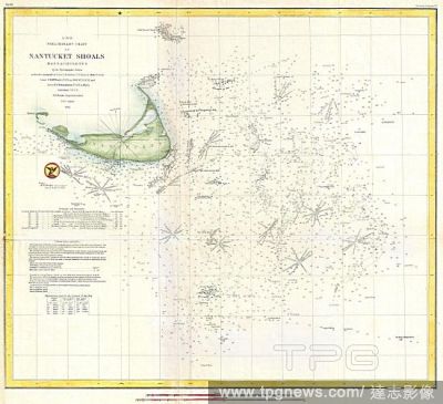
Editorial 1852, U.S.C.S. Map or Chart of Nantucket, Massachusetts.
- 2019-01-23
- 1
Editorial 1860, U.S. Coast Survey Map of Block Island, Buzzard Bay, Nantucket and Marthas Vineyard.
- 2019-01-23
- 1

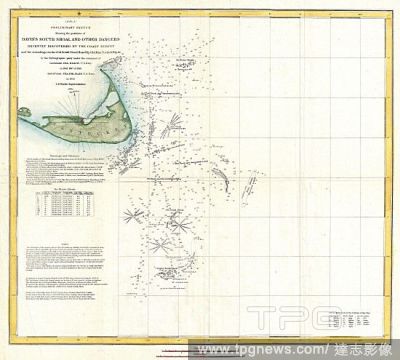
Editorial 1846, U.S. Coast Survey Map of Nantucket, first U.S.C.S. Map of the Davis Shoals.
- 2019-01-23
- 1

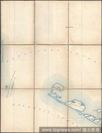
Editorial 1866, U.S. Coast Survey Map of Nantucket Harbor, Nantucket.
- 2019-01-23
- 1
Editorial 1854, U.S. Coast Survey Nautical Chart or Map of Nantucket, Massachusetts.
- 2019-01-23
- 1

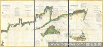
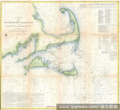
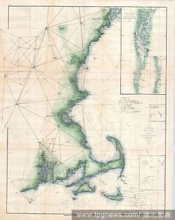
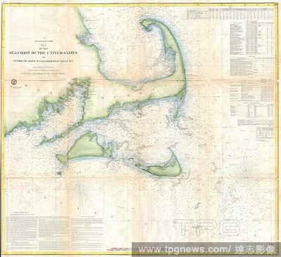
Editorial 1873, U.S. Coast Survey Chart of Map of Cape Cod, Nantucket, Marthas Vineyard, and Cape Ann.
- 2019-01-23
- 1
Editorial 1887, Pocket Map Version of the U.S. Geological Survey Map of western Nantucket, Massachusetts.
- 2019-01-23
- 1
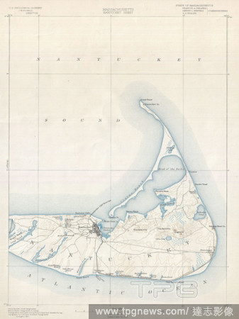
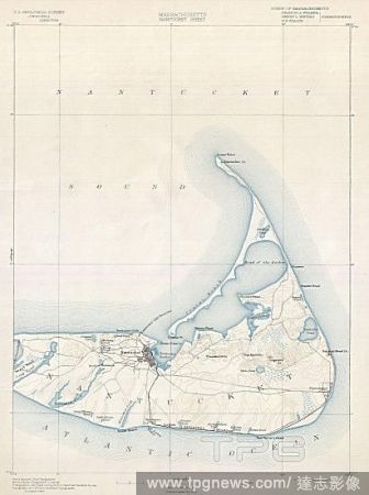
Editorial 1898, U.S. Geological Survey Map of Nantucket, Massachusetts.
- 2019-01-23
- 1
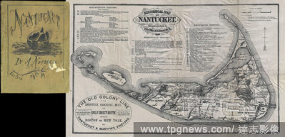
Editorial 1889, Ewer Map of Nantucket, Massachusetts.
- 2019-01-23
- 1
Editorial 1857, U.S. Coast Survey Map of Cape Cod, Nantucket, and Martha's Vineyard.
- 2019-01-23
- 1
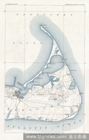
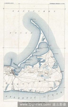
Editorial 1919, U.S. Geological Survey Map of Nantucket, Massachusetts.
- 2019-01-23
- 1

Editorial 1860, U.S. Coast Survey Chart or Map of Nantucket Island, Massachusetts.
- 2019-01-23
- 1
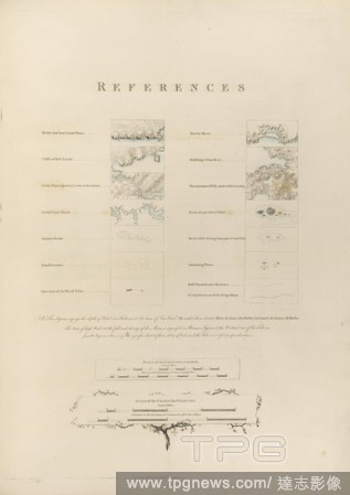
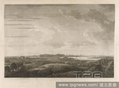
Editorial Topographical features. [A Chart of Nantucket Island... 1776. Various topographical features. Image taken from: [A Chart of Nantucket Island and part of Martha's Vineyard]. Published in 1776 . Source: Maps.184.m.3.(37). Language: English.
- 2019-01-23
- 1

Editorial Boston. [A Chart of Nantucket Island... 1776. Various views of Boston including the Bay and the Harbour. Image taken from: [A Chart of Nantucket Island and part of Martha's Vineyard]. Published in 1776 . Source: Maps.184.m.3.(37), page 26. Language: E...
- 2019-01-23
- 1

Editorial Topographical features. [A Chart of Nantucket Island... 1776. Various topographical features. Image taken from: [A Chart of Nantucket Island and part of Martha's Vineyard]. Published in 1776 . Source: Maps.184.m.3.(37). Language: English.
- 2018-12-06
- 1
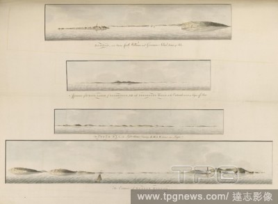
Editorial Boston. [A Chart of Nantucket Island... 1776. Various views of Boston including the Bay and the Harbour. Image taken from: [A Chart of Nantucket Island and part of Martha's Vineyard]. Published in 1776 . Source: Maps.184.m.3.(37), page 26. Language: E...
- 2018-12-06
- 1
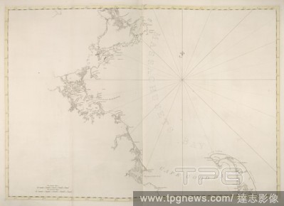
Editorial Massachussetts Bay. [A Chart of Nantucket Island... 1776. A map of Massachussetts Bay and Cape Cod Bay. Image taken from: [A Chart of Nantucket Island and part of Martha's Vineyard]. Published in 1776 . Source: Maps.184.m.3.(37), page 35. Language: En...
- 2018-12-06
- 1
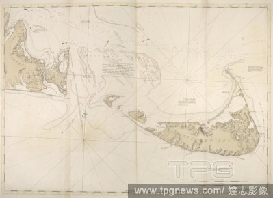
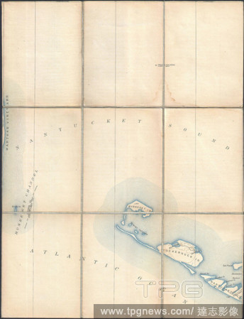
Editorial Nantucket Island. [A Chart of Nantucket Island... 1776. A map of Nantucket Island and part of Martha's Vineyard. Image taken from: [A Chart of Nantucket Island and part of Martha's Vineyard]. Published in 1776 . Source: Maps.184.m.3.(37), page 37. Lan...
- 2018-12-06
- 1
Editorial Boston. [A Chart of Nantucket Island... 1776. A view of Boston taken on the road to Dorchester. Image taken from: [A Chart of Nantucket Island and part of Martha's Vineyard]. Published in 1776 . Source: Maps.184.m.3.(37), page 24. Language: English.
- 2018-12-06
- 1

Editorial Lambs, Nantucket. Dated: 1874. Dimensions: overall: 48.26 ? 39.69 cm (19 ? 15 5/8 in.) framed: 63.18 ? 54.93 ? 5.24 cm (24 7/8 ? 21 5/8 ? 2 1/16 in.). Medium: oil on board.
- 2018-09-25
- 1

Editorial The New Bonnet.
- 2018-08-06
- 1
Editorial 1853, U.S. Coast Survey Nautical Chart or Map of Nantucket, Massachusetts.
- 2018-08-06
- 1

Editorial Brothers of the Night (Nantucket), 1926, Drypoint, plate: 7 5/8 x 9 1/2 in. (19.4 x 24.1 cm), Prints, Henry Emerson Tuttle (American, Lake Forest, Illinois 1890?1946 New Haven, Connecticut).
- 2018-08-06
- 1
Editorial 1849, U.S. Coast Survey Map of Nantucket and the Davis Shoals.
- 2018-08-06
- 1
Editorial 1852, U.S.C.S. Map or Chart of Nantucket, Massachusetts.
- 2018-08-06
- 1

Editorial 1860, U.S. Coast Survey Map of Block Island, Buzzard Bay, Nantucket and Marthas Vineyard.
- 2018-08-06
- 1
Editorial 1846, U.S. Coast Survey Map of Nantucket, first U.S.C.S. Map of the Davis Shoals.
- 2018-08-06
- 1

Editorial 1866, U.S. Coast Survey Map of Nantucket Harbor, Nantucket.
- 2018-08-06
- 1
Editorial 1854, U.S. Coast Survey Nautical Chart or Map of Nantucket, Massachusetts.
- 2018-08-06
- 1
Editorial 1873, U.S. Coast Survey Chart of Map of Cape Cod, Nantucket, Marthas Vineyard, and Cape Ann.
- 2018-08-06
- 1
Editorial 1887, Pocket Map Version of the U.S. Geological Survey Map of western Nantucket, Massachusetts.
- 2018-08-06
- 1
Editorial 1898, U.S. Geological Survey Map of Nantucket, Massachusetts.
- 2018-08-03
- 1

Editorial 1889, Ewer Map of Nantucket, Massachusetts.
- 2018-08-03
- 1
Editorial 1857, U.S. Coast Survey Map of Cape Cod, Nantucket, and Martha's Vineyard.
- 2018-08-03
- 1
Editorial 1919, U.S. Geological Survey Map of Nantucket, Massachusetts.
- 2018-08-03
- 1

Editorial 1860, U.S. Coast Survey Chart or Map of Nantucket Island, Massachusetts.
- 2018-08-03
- 1
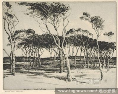
Editorial Seaward Pines, Nantucket, 1932, Drypoint, plate: 11 3/8 x 8 7/8 in. (28.9 x 22.5 cm), Prints, Henry Emerson Tuttle (American, Lake Forest, Illinois 1890?1946 New Haven, Connecticut).
- 2018-08-03
- 1
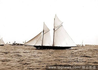
Editorial The Volunteer, Goelet Cup Race, August 7, 1891, Nantucket (Steamboat), Volunteer (Yacht), Goelet Cup Race, Yachts, Regattas, 1891.
- 2018-07-27
- 1
 Loading