
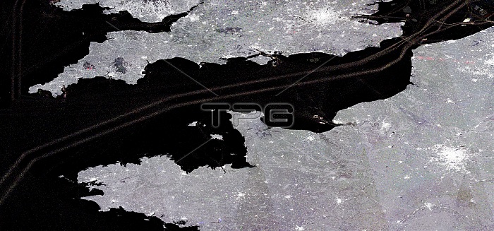
English Channel and shipping lanes, satellite radar image. Hundreds of radar images spanning the period 2016 to 2018 have been combined into a single image to show the busy maritime traffic along the English Channel's shipping lanes. The boats are colour-coded by year: 2016 (blue), 2017 (green) and 2018 (red). Busy cross-Channel routes are seen at right between Dover and Calais and other nearby ports. Image data obtained by the Copernicus Sentinel-1 satellites. Image published in 2019.
| px | px | dpi | = | cm | x | cm | = | MB |
Details
Creative#:
TOP25469182
Source:
達志影像
Authorization Type:
RM
Release Information:
須由TPG 完整授權
Model Release:
N/A
Property Release:
N/A
Right to Privacy:
No
Same folder images:
BRITISHBUSYCHANNELPORTSCOMPOSITECROSS-CHANNELCROWDEDENGLISHEUROPEANFRENCHGEOGRAPHICALINDUSTRIALMARINEMARITIMENO-ONENOBODYSEQUENCESERIESSHIPPINGLANESSHIPSTRAFFICTRANSPORTUNITEDKINGDOMCHANNELSHIPPINGLANEEUROPEUKFRANCEATLANTICENGLANDBRITAINTRANSPORTINGEARTHOBSERVATIONGEOGRAPHYSHIPPINGINDUSTRYTRANSPORTATIONSATELLITEIMAGEFROMSPACERADARSATELLITECOPERNICUSSENTINEL-121STCENTURY201620172018
20162017201821STATLANTICBRITAINBRITISHBUSYCENTURYCHANNELCHANNELCOMPOSITECOPERNICUSCROSS-CHANNELCROWDEDENGLANDENGLISHEUROPEANFRANCEFRENCHFROMGEOGRAPHICALGEOGRAPHYIMAGEINDUSTRIALINDUSTRYKINGDOMLANEEUROPELANESMARINEMARITIMENO-ONENOBODYOBSERVATIONPORTSRADARSATELLITESATELLITESENTINEL-1SEQUENCESERIESSHIPPINGSHIPPINGSHIPPINGSHIPSSPACETRAFFICTRANSPORTTRANSPORTATIONTRANSPORTINGEARTHUKUNITED
 Loading