
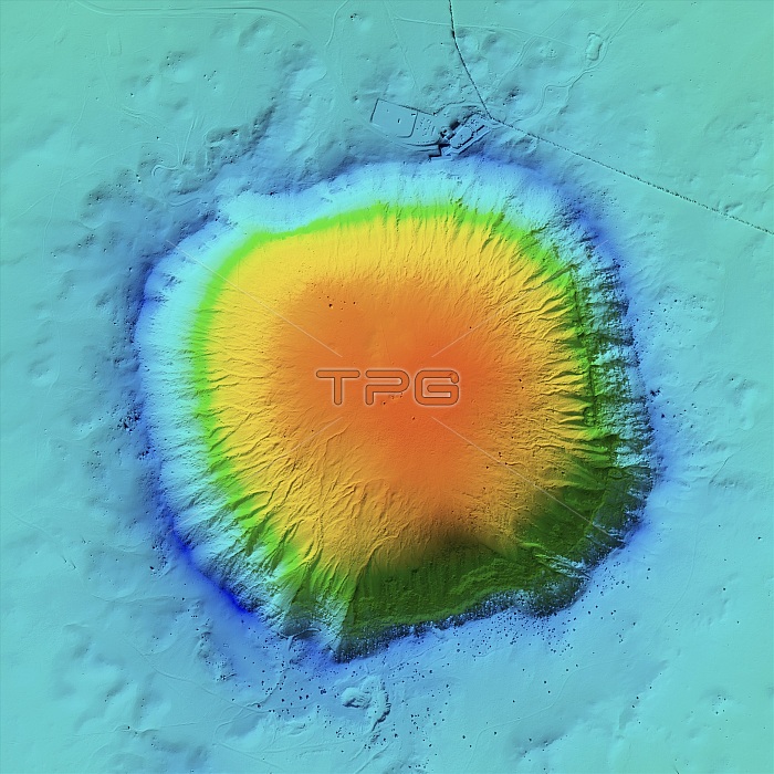
Barringer Crater, LiDAR image. This crater, also known as Meteor Crater, is located in Arizona, USA. It was formed over 50,000 years ago by the impact of an iron meteorite (space rock) colliding with the Earth. The meteorite is thought to have weighed more than 10,000 tonnes. The resulting crater is 183 metres deep, with a diameter of 1200 metres. It is named after the US mining engineer and businessman Daniel Barringer (1860-1929) who first proposed the meteorite impact theory. The site was designated a National Natural Landmark in 1967. LiDAR combines optical and laser imaging to produce digital elevation maps (DEMs), with differences in elevation shown by the colour-coding of the image. Image data obtained by the National Center for Airborne Laser Mapping (NCALM) in the USA.
| px | px | dpi | = | cm | x | cm | = | MB |
Details
Creative#:
TOP25469171
Source:
達志影像
Authorization Type:
RM
Release Information:
須由TPG 完整授權
Model Release:
N/A
Property Release:
N/A
Right to Privacy:
No
Same folder images:
 Loading