
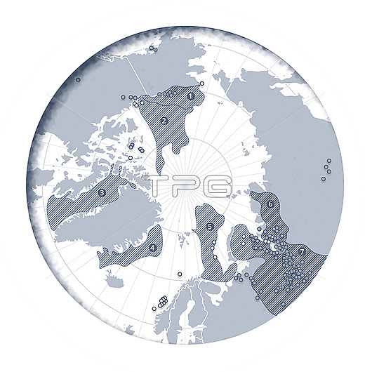
Map showing location of potential Arctic fossil fuel resources. It is estimated that 87% of the Arctic region's oil and gas resources are located in seven geological basins (shaded). From numbers 1-7, they are: Arctic Alaska Basin, Amerasia Basin, West Greenland East Canada Basin, East Greenland Rift Basin, East Barents Basin, Yenisey-Khatanga Basin and the West Siberian Basin. Also shown are offshore oil discoveries (white circles), land based oil discoveries (blue circles).
| px | px | dpi | = | cm | x | cm | = | MB |
Details
Creative#:
TPG33842817
Source:
達志影像
Authorization Type:
RF
Release Information:
須由TPG 完整授權
Model Release:
n/a
Property Release:
n/a
Right to Privacy:
No
Same folder images:
illustrationartworkcgidigitally-generatednobodyno-onetextdatavisualizationvisualisationdatainfographicinfographicalchartgraphmapglobeplanetearthgeographygeographicalarcticarcticcirclepolaroilgasshippingtransportationresourcesfossilfuelsindustryicemeltmeltingiceglobalwarmingclimatechangeicelossicecapseaiceoilfieldgasfieldnaturalgasshrinkingiceretreatingicenorthpoleArcticAlaskaBasinAmerasiaBasinWestGreenlandEastCanadaBasinEastGreenlandRiftBasinEastBarentsBasinYenisey-KhatangaBasinWestSiberianBasin
AlaskaAmerasiaArcticBarentsBasinBasinBasinBasinBasinBasinBasinCanadaEastEastEastGreenlandGreenlandRiftSiberianWestWestYenisey-Khatangaarcticarcticartworkcapcgichangechartcircleclimatedatadatadigitally-generatedearthfieldfieldfossilfuelsgasgasgasgeographicalgeographyglobalglobegraphiceiceiceiceiceiceiceillustrationindustryinfographicinfographicallossmapmeltmeltingnaturalno-onenobodynorthoiloilplanetpolarpoleresourcesretreatingseashippingshrinkingtexttransportationvisualisationvisualizationwarming
 Loading