
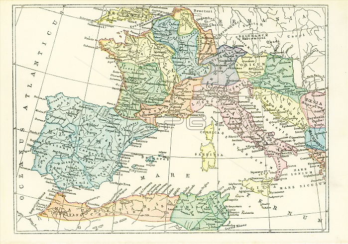
This map dates to 1897 and shows the western Provinces of the ancient Roman Empire. Among them are: Hispania, Mauretania, Numidia, Itralia, Gallia, Britannia, Germania, Illyricum, Moesia, Macedonia, Egyptus, Noricum, Narbonensis, Sardinia, Corsica, Sicilia, Rhaetia, Pannonia.
| px | px | dpi | = | cm | x | cm | = | MB |
Details
Creative#:
TOP29915360
Source:
達志影像
Authorization Type:
RM
Release Information:
須由TPG 完整授權
Model Release:
No
Property Release:
No
Right to Privacy:
No
Same folder images:
WesternProvincesofRomanEmpireWesternProvincesRomanEmpireWesternProvincesRomanRomesprovincesHispaniaMauretaniaNumidiaItraliaGalliaBritanniaGermaniaIllyricumMoesiaMacedoniaEgyptusNoricumNarbonensisSardiniaCorsicaSiciliaRhaetiaPannoniaRomanworldancientRomanworldmapofromanworldmapofancientRomanworldancientRomeRomemapRomanprovincesRomanprovinces
BritanniaCorsicaEgyptusEmpireEmpireGalliaGermaniaHispaniaIllyricumItraliaMacedoniaMauretaniaMoesiaNarbonensisNoricumNumidiaPannoniaProvincesProvincesProvincesRhaetiaRomanRomanRomanRomanRomanRomanRomanRomanRomeRomeRomesSardiniaSiciliaWesternWesternWesternancientancientancientmapmapmapofofofprovincesprovincesprovincesromanworldworldworldworld
 Loading