
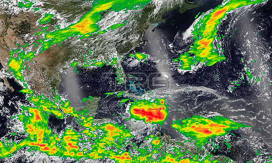
Composite satellite image showing rainfall levels over the Caribbean Sea and Gulf of Mexico during Hurricane Beryl on the 3rd July 2024. The colour scale indicates rainfall, with the lightest green being 0.1 mm of rainfall per hour, and the darkest red being around 7 mm per hour. The eye of the storm is seen as a concentrated red patch roughly central, beneath Cuba. Beryl first made landfall on the island of Carriacou, Grenada, on the afternoon of the 1st July as a category 4 storm with sustained winds of 240 kilometres per hour. On the 2nd July Beryl peaked as a category 5 hurricane, the earliest in the Atlantic hurricane season that a hurricane has reached category 5 since records began. As of 25th July 2024, 64 confirmed deaths have been attributed to Beryl, as well as estimated damages of over 6 billion US dollars. Image created using data from NASAs Land, Atmosphere Near real-time Capability for Earth observations (LANCE) satellites.
| px | px | dpi | = | cm | x | cm | = | MB |
Details
Creative#:
TOP29909572
Source:
達志影像
Authorization Type:
RM
Release Information:
須由TPG 完整授權
Model Release:
N/A
Property Release:
N/A
Right to Privacy:
No
Same folder images:
 Loading