
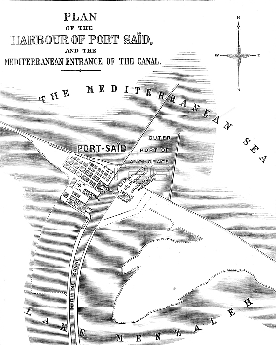
The Isthmus of Suez Maritime Canal: plan of the Harbour of Port Sa?d and the Mediterranean entrance of the Canal, 1869. Map of ...the new artificial harbour [which] has been constructed by running out into the sea two breakwaters, or moles, which are formed of huge blocks of concrete...The western breakwater extends from the shore 2400 yards in a straight line towards the north...The eastern breakwater leaves the shore at the distance of 1530 yards of the commencement of the western breakwater, and extends nearly north for a distance of 2070 yards...the harbour is well protected from the strong and prevailing northwest winds. The portion of the harbour affording shelter to vessels is nearly 500 acres in extent; and, although the depth of water is not sufficient for the largest men-of-war, it is quite sufficient for ordinary merchantmen, if the present depth be maintained...The new town of Port Sa?d now has a population of ten thousand persons. The basins, quays, and other accommodation at Port Sa?d are very conveniently designed for the requirements connected with the traffic of the canal; and no doubt some of the repairing-shops now used for the temporary purposes of the works will permanently remain. From "Illustrated London News", 1869.
| px | px | dpi | = | cm | x | cm | = | MB |
Details
Creative#:
TOP29822528
Source:
達志影像
Authorization Type:
RM
Release Information:
須由TPG 完整授權
Model Release:
no
Property Release:
no
Right to Privacy:
No
Same folder images:
 Loading