
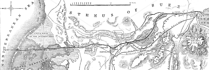
The Isthmus of Suez Maritime Canal: plan of the canal, with the small fresh-water canal, 1869. Vessels will be able to steam through, or be towed through, from [the Mediterranean] sea to [the Red] sea in about sixteen hours...leaving Port Sa?d the canal enters Lake Menzaleh, through which the channel runs for twenty-nine miles...Leaving Lake Menzaleh at Kantara, a station on the desert route between Egypt and Syria, the course of the canal lies through low sandhills. It then enters Lake Ballah, traverses it for a distance of eight miles, and then enters a deep cutting extending from El Ferdane to Lake Timsah. Near El Guisr, the deepest cutting throughout the line had to be excavated, varying from 60 ft. to 70 ft. The characteristics of the first half of the Maritime Canal are that about thirty-four miles of its course lie through lakes, the remainder through elevated plateaux. The second half of the channel, from Isma?lia to the Red Sea, divides into two: in the first the canal skirts the eastern shore of Lake Timsah and enters the cuttings at Toussoum and Serapeum; in the second it passes through the Bitter Lakes for twenty-four miles, goes through the last cutting at Chalouf, and enters the Red Sea a mile to the south-east of Suez. From "Illustrated London News", 1869.
| px | px | dpi | = | cm | x | cm | = | MB |
Details
Creative#:
TOP29822527
Source:
達志影像
Authorization Type:
RM
Release Information:
須由TPG 完整授權
Model Release:
no
Property Release:
no
Right to Privacy:
No
Same folder images:
 Loading