
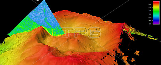
Bathymetric map of an underwater methane seep (green vertical line) on Vailulu?™u Seamount, an underwater mountain in the Pacific Ocean, created using multibeam sonar. Methane seeps are plumes of methane gas emerging from underwater fissures in the Earths crust. They are an important source of carbon and energy for deep sea ecosystems. The colour scale indicates depth: red/yellow indicates shallower areas and purple/blue the deeper ones. This map was created using sonar data collected by the Okeanos Explorer and processed by NOAAs Office of Ocean Exploration and Research (OER).
| px | px | dpi | = | cm | x | cm | = | MB |
Details
Creative#:
TOP29820627
Source:
達志影像
Authorization Type:
RM
Release Information:
須由TPG 完整授權
Model Release:
N/A
Property Release:
N/A
Right to Privacy:
No
Same folder images:
Restriction:
This image may not be used to state or imply NOAA endorsement of any company or product
 Loading