
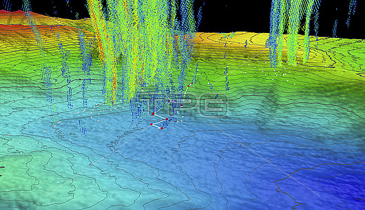
Composite bathymetric map of part of Norfolk Canyon, an underwater canyon off the east US coast created using multibeam sonar. Vertical lines indicate plumes of methane gas which have been superimposed from a separate map. The route of a dive undertaken by a remotely operated vehicle (ROV) is shown by white lines and red dots. Methane plumes in this region have been recorded at 900 metres tall. Methane is an important source of carbon and energy for deep sea ecosystems. This map was created using bathymetric data from the Okeanos Explorer multibeam sonar and is contoured at 10 metre intervals. All data shown at two times vertical exaggeration. The colour scale indicates depth: red/yellow indicates shallower areas and purple/blue the deeper ones.
| px | px | dpi | = | cm | x | cm | = | MB |
Details
Creative#:
TOP29820625
Source:
達志影像
Authorization Type:
RM
Release Information:
須由TPG 完整授權
Model Release:
N/A
Property Release:
N/A
Right to Privacy:
No
Same folder images:
Restriction:
This image may not be used to state or imply NOAA endorsement of any company or product
 Loading