
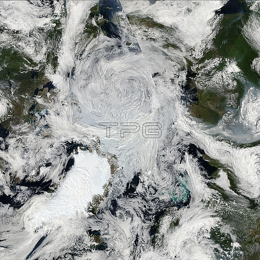
Satellite image of a cyclone over the Arctic Ocean on the 28th of July 2020. Studies have suggested that Arctic cyclones may intensify with climate change due to sea ice loss and warming temperatures. These storms can in turn disrupt sea ice and bring warmer water upwards. Image acquired by the Moderate Resolution Imaging Spectroradiometer (MODIS) on NASA?™s Terra and Aqua satellites.
| px | px | dpi | = | cm | x | cm | = | MB |
Details
Creative#:
TOP29676180
Source:
達志影像
Authorization Type:
RM
Release Information:
須由TPG 完整授權
Model Release:
N/A
Property Release:
N/A
Right to Privacy:
No
Same folder images:
2000s20202020s21stcentury28july2020aquaarcticarcticoceanclimatechangecycloneearthearthobservationextremeweatherfromabovegeographicalgeographyglobalwarmingiceicecapslandmeteorologicalmeteorologymoderateresolutionimagingspectroradiometermodisnasano-onenobodyoceanpolarpolarregionpolesatelliteimagesatellitesseaseaicestormstormyterrawaterweather
2000s2020s21st2820202020aboveaquaarcticarcticcapscenturychangeclimatecycloneearthearthextremefromgeographicalgeographyglobaliceiceiceimageimagingjulylandmeteorologicalmeteorologymoderatemodisnasano-onenobodyobservationoceanoceanpolarpolarpoleregionresolutionsatellitesatellitesseaseaspectroradiometerstormstormyterrawarmingwaterweatherweather
 Loading