
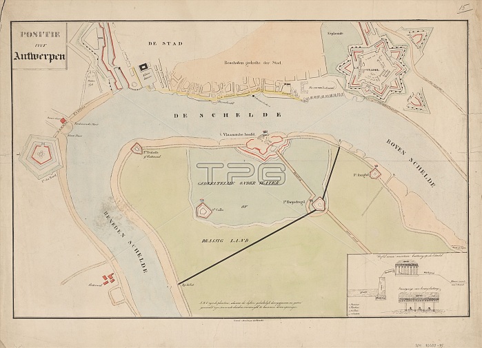
Map of Antwerp during the siege by the French, 1832, (1832-1833). Creators: Anon, Johannes Paulus Houtman.
| px | px | dpi | = | cm | x | cm | = | MB |
Details
Creative#:
TOP29406801
Source:
達志影像
Authorization Type:
RM
Release Information:
須由TPG 完整授權
Model Release:
Not Required
Property Release:
Not Required
Right to Privacy:
No
Same folder images:
EuroperiverbuildinghistoricalfortfortsartsmapcountrydetailartmuseumgeographyNetherlandsDutchBelgiumcolorscenefortificationsfortificationAntwerpwarcitadeldepictionlocationcenturydrawinggalleryprintartefactconceptexhibitiondetailsexhibitartifactwatercolourillustratedartgalleryColourinset19thcenturydescriptionNetherlandishnineteenthcenturysiegeculturehistoryhistoricgeographicalfeatureRijksmuseumScheldeSiegeofAntwerpTGNillustrationmapAnonAnonymousEscautRiverEscautRiverScheldewatercolouronpaperartcentrepaperHeritageArtPrintLowCountries19th-centuryAnverswatercolour(paint)JohannesPaulusHoutmanHoutmanJohannesPaulus
(paint)19th19th-centuryAnonAnonymousAntwerpAntwerpAnversArtBelgiumColourCountriesDutchEscautEscautEuropeHeritageHoutmanHoutmanJohannesJohannesLowNetherlandishNetherlandsPaulusPaulusPrintRijksmuseumRiverRiverScheldeScheldeSiegeTGNartartartartefactartifactartsbuildingcentrecenturycenturycenturycitadelcolorconceptcountryculturedepictiondescriptiondetaildetailsdrawingexhibitexhibitionfeaturefortfortificationfortificationsfortsgallerygallerygeographicalgeographyhistorichistoricalhistoryillustratedillustrationinsetlocationmapmapmuseumnineteenthofonpaperpaperprintriverscenesiegewarwatercolourwatercolourwatercolour
 Loading