
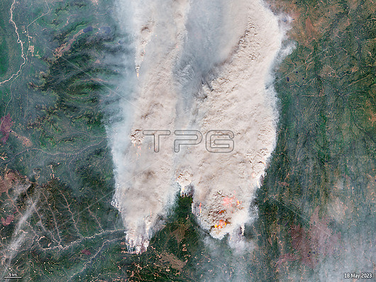
Satellite image of smoke and flames from a wildfire burning in Donnie Creek, British Columbia, Canada, on 18th May 2023. This fire was still burning and out of control on the 15th June, having burnt over 5,000 square kilometres of land, making it the second largest fire in the area's history. In May hundreds of wildfires burnt across Canada after a heatwave and an abnormally dry spring. Data obtained by the Copernicus Sentinel-2 satellite.
| px | px | dpi | = | cm | x | cm | = | MB |
Details
Creative#:
TOP28995784
Source:
達志影像
Authorization Type:
RM
Release Information:
須由TPG 完整授權
Model Release:
Not Available
Property Release:
Not Available
Right to Privacy:
No
Same folder images:
Restriction:
This image may not be used to state or imply ESA endorsement of any company or product
18may20232000s2020s21stcenturyatmosphereatmosphericburningcanadacanadianclimatechangeclimatecrisisclimateemergencyclimatologicalclimatologycopernicussentinel-2earthobservationenvironmentenvironmentalsciencefirefiresflamesfromspaceglobalwarmingnaturaldisasterno-onenobodynorthamericanorthamericansatellitesmokewildfirewildfireswildfirewildland
182000s2020s202321stamericaamericanatmosphereatmosphericburningcanadacanadiancenturychangeclimateclimateclimateclimatologicalclimatologycopernicuscrisisdisasterearthemergencyenvironmentenvironmentalfirefirefiresfiresflamesfromglobalmaynaturalno-onenobodynorthnorthobservationsatellitesciencesentinel-2smokespacewarmingwildwildwildfirewildland
 Loading