
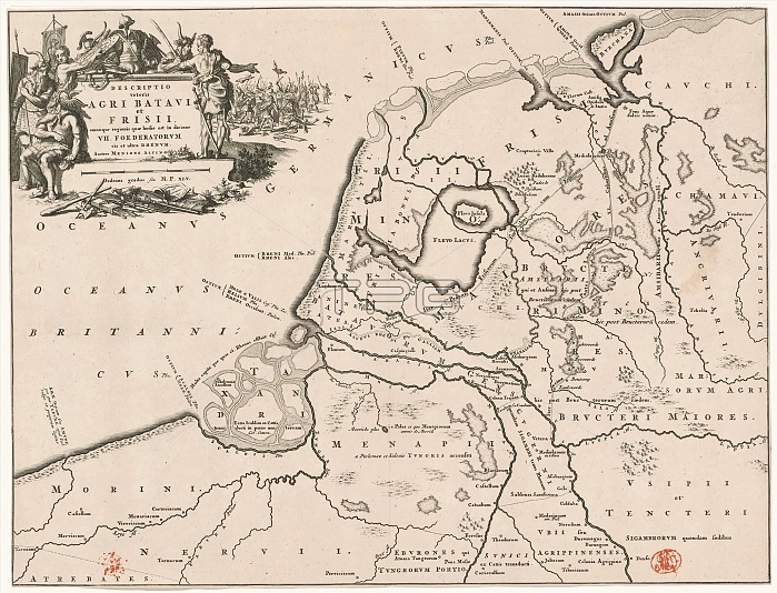
Historical map of the Netherlands with the territories of the Batavians and Frisians, Descriptio veteris agri Batavi et Frisii (...) (title on object), Top left cartouche with title, around it weapons and Germanic warriors depicted (possibly Batavians and Frisians), in the background a battle scene. Scale stick below cartouche: Dodrans gradus seu M.P. XLV. print maker: Jan Luyken, Menso Alting, (mentioned on object), Netherlands, 1697 - 1700 and/or 1725, paper, engraving, etching, height 319 mm x width 420 mm.
| px | px | dpi | = | cm | x | cm | = | MB |
Details
Creative#:
TOP28937942
Source:
達志影像
Authorization Type:
RM
Release Information:
須由TPG 完整授權
Model Release:
No
Property Release:
No
Right to Privacy:
No
Same folder images:
historicalmapnetherlandsterritoriesbataviansfrisiansdescriptioveterisagribatavietfrisiititleobjecttopleftcartouchetitleweaponsgermanicwarriorsdepictedbataviansfrisiansbackgroundbattlescenescalestickcartouchedodransgradusseumpxlvprintmakerjanluykenmensoaltingmentionedobjectnetherlands169717001725paperengravingetchingheight319mmxwidth420mm
319420169717001725agrialtingbackgroundbatavibataviansbataviansbattlecartouchecartouchedepicteddescriptiododransengravingetetchingfrisiansfrisiansfrisiigermanicgradusheighthistoricaljanleftluykenmmakermapmensomentionedmmmmnetherlandsnetherlandsobjectobjectppaperprintscalesceneseustickterritoriestitletitletopveteriswarriorsweaponswidthxxlv
 Loading