
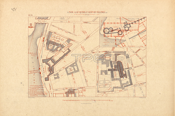
Paris (France); 6th arrondissement;Quartier de Saint-Germain-des-Pr閟 and Quartier de la Monnaie.- "Plan du Quartier St. Germain 1734 / Plan de la Porte de Nesle en 1665 / Plan du Quartier St. Germain des Pr閟 et du Quartier de la Monnaie (1877)". -(Map of the quarter with the Saint-Germain-des-Pr閟 abbey; the H魌el de Conti and the Coll鑗e des Quatre-Nations as it was in 1734. With an additional map: Tour and Porte de Nesle as it was in 1665. On tracing paper State of the year 1877 and plan of the Biblioth鑡ue Mazarine).Lithograph after a drawing by F閛dor (Theodor) Hoffbauer (1839-1922).From: F閐or Hoffbauer; Paris ?travers les 鈍es; Aspects successifs des monuments et quartiers historiques de Paris depuis le XIIIe si鑓le jusqu'?nos jours; texts by MM. 蒬ouard Fournier; Paul Lacroix; A. de Montaiglon; Alfred Bonnardot; Jules Cousin; Franklin; Valentin Dufour; etc.; vol. 2; 2nd edition Paris (Firmin-Didot) 1885; chapter 5; plate VII.Private collection.
| px | px | dpi | = | cm | x | cm | = | MB |
Details
Creative#:
TOP28193975
Source:
達志影像
Authorization Type:
RM
Release Information:
須由TPG 完整授權
Model Release:
No
Property Release:
No
Right to Privacy:
No
Same folder images:
 Loading