
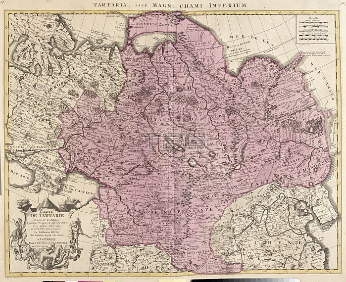
LRI4706814 Map of Tartaria (Central Asia, Siberia, Turkestan, Mongolia and Manchuria) (etching, 1730) by Delisle, Guillaume (1675-1726); Private Collection; (add.info.: Map of Tartaria (Central Asia, Siberia, Turkestan, Mongolia and Manchuria) - Strong water extracted from the ???ew Atlas containing all parts of the world??1730 by Guillaume de L\'Isle (1675-1726)); Luisa Ricciarini.
| px | px | dpi | = | cm | x | cm | = | MB |
Details
Creative#:
TOP27696804
Source:
達志影像
Authorization Type:
RM
Release Information:
須由TPG 完整授權
Model Release:
No
Property Release:
No
Right to Privacy:
No
Same folder images:
asianrussiaengravinggeographicalmapChineserussianMongoliageographysiberiachinamongolianricciariniAtlas(Book)1818th18th18thXVIII18thcenturyasianasianrussiaengravinggeographicalmapchineserussianmongoliageographyrussiansiberiachinamongolianchinesericciariniAtlas(Book)1818th18th18thXVIII18thcenturymongolianasianasian
(Book)(Book)181818th18th18th18th18th18th18th18thAtlasAtlasChineseMongoliaXVIIIXVIIIasianasianasianasianasiancenturycenturychinachinachinesechineseengravingengravinggeographicalgeographicalgeographygeographymapmapmongoliamongolianmongolianmongolianricciariniricciarinirussiarussiarussianrussianrussiansiberiasiberia
 Loading