
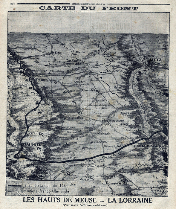
XEE4170397 First World War 1914-1918. Map of the front dated September 11, 1918. Les hauts de Meuse: la Lorraine with the delimitation of the Franco-German borders (to follow the American offensive). Engraving in ??????Le Petite Journal?????? on 13/10/1918. by Unknown Artist; Private Collection; (add.info.: First World War 1914-1918, Map of the front on September 11, 1918, Les Hauts de Meuse: la Lorraine with the delimitation of the Franco-German borders (to follow the American offensive). Engraving in ??????Le Petite Journal?????? on 13/10/1918,); Stefano Bianchetti.
| px | px | dpi | = | cm | x | cm | = | MB |
Details
Creative#:
TOP27661301
Source:
達志影像
Authorization Type:
RM
Release Information:
須由TPG 完整授權
Model Release:
No
Property Release:
No
Right to Privacy:
No
Same folder images:
mapblackandwhiteWarengravingGermanygeographicalmapFrenchgeographygermanleeFranceWar191419182020th20thXXXXth20thcenturyFirstWorldWar(1stWorldWar)Iere14-18or1914-1918)borderBianchettiCORmzengravingblackandwhiteengravinggermanygeographicalmapfrenchgeographygermanleefrenchfranceWar191419182020th20thXXXXth20thcenturyFirstWorldWar(1stWorldWar)iere14-18or1914-1918)borderBianchettiCORgerman
(1st(1st14-1814-182020191419141914-1918)1914-1918)1918191820th20th20th20th20th20thBianchettiCORBianchettiCORFirstFirstFranceFrenchGermanyIereWarWarWarWarWarWar)War)WorldWorldWorldWorldXXXXXXthXXthandandblackblackborderbordercenturycenturyengravingengravingfrancefrenchfrenchgeographicalgeographicalgeographygeographygermangermangermangermanyiereleeleemapmapmapmzengravingororwhitewhite
 Loading