
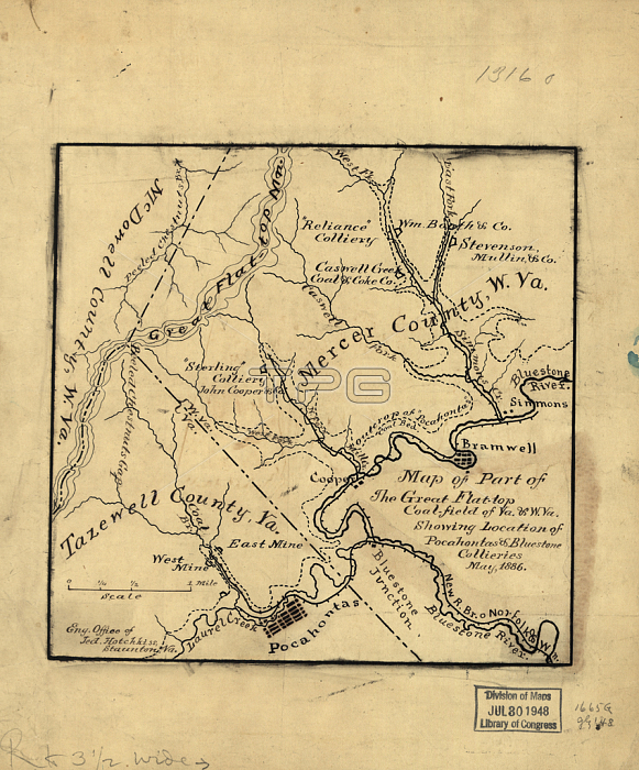
4072490 Map of part of the great Flat-top coal-field of Va. & W. Va. showing location of Pocahontas & Bluestone collieries, May 1886 (engraving) by Hotchkiss, Jedediah (1828-99); Private Collection.
| px | px | dpi | = | cm | x | cm | = | MB |
Details
Creative#:
TOP27627740
Source:
達志影像
Authorization Type:
RM
Release Information:
須由TPG 完整授權
Model Release:
No
Property Release:
No
Right to Privacy:
No
Same folder images:
fieldsmapplancartographyAmericaAmericanUnitedStatesUSAUS19thcenturyindustryVirginiaWestVirginiaPocahontasCollierymineBluestoneCollieryminescolliariescoalfieldcoalfieldscoalfieldMercerCountyTazewellCountyMcDowellCountyGreatFlatTopindustrialmapplancartographyAmericaAmericanUnitedStatesUSAUS19thcenturyindustryVirginiaWestVirginiaPocahontasCollierymineBluestoneCollieryminescolliariescoalfieldcoalfieldscoalfieldMercerCountyTazewellCountyMcDowellCountyGreatFlatTopindustrial
19th19thAmericaAmericaAmericanAmericanBluestoneBluestoneCollieryCollieryCollieryCollieryCountyCountyCountyCountyCountyCountyFlatFlatGreatGreatMcDowellMcDowellMercerMercerPocahontasPocahontasStatesStatesTazewellTazewellTopTopUSUSUSAUSAUnitedUnitedVirginiaVirginiaVirginiaVirginiaWestWestcartographycartographycenturycenturycoalcoalcoalfieldcoalfieldcoalfieldscoalfieldscolliariescolliariesfieldfieldfieldsindustrialindustrialindustryindustrymapmapminemineminesminesplanplan
 Loading