
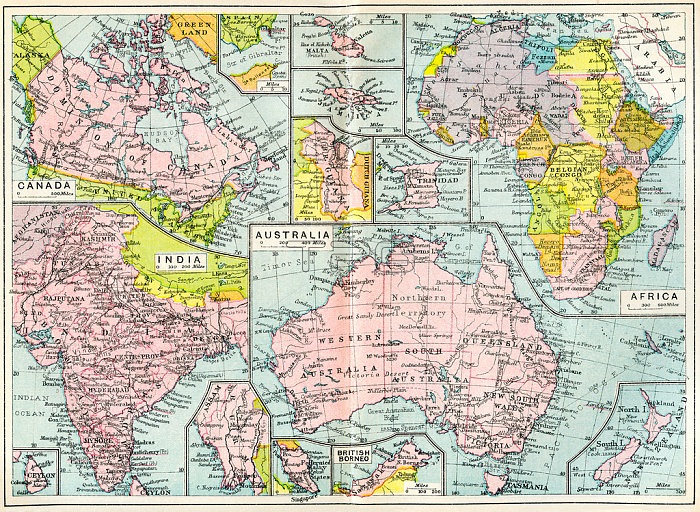
3614250 Map of British possessions in 1914 at the outbreak of WWI, from The British Empire Universities Modern English Illustrated Dictionary, pub.1914 by English School, (20th century); (add.info.: Map of British possessions in 1914 at the outbreak of WWI. From The British Empire Universities Modern English Illustrated Dictionary, published 1914.); English, out of copyright.
| px | px | dpi | = | cm | x | cm | = | MB |
Details
Creative#:
TOP27584241
Source:
達志影像
Authorization Type:
RM
Release Information:
須由TPG 完整授權
Model Release:
No
Property Release:
No
Right to Privacy:
No
Same folder images:
FirstWorldWar(1914-1918)TheGreatWarworldwar1worldwarIWWIWar191419181914-1918WWIWWOne)1914-1918warcountrygeographicalgreatcenturyhistoricaloutbreakcountriesterritoriesarchivaloldarchive20thoneworldbritishtwentiethmapgeographypossessionsfirstwarengravinghistoryillustration1914geographicalgreatcenturyhistoricaloutbreakcountriesterritoriesarchivaloldarchive20thoneworldbritishtwentiethmapgeographypossessionsfirstwarengravinghistoryillustration1914wwi
(1914-1918)11914191419141914-19181914-1918191820th20thFirstGreatIOne)TheWWWWIWWIWarWarWarWorldarchivalarchivalarchivearchivebritishbritishcenturycenturycountriescountriescountryengravingengravingfirstfirstgeographicalgeographicalgeographygeographygreatgreathistoricalhistoricalhistoryhistoryillustrationillustrationmapmapoldoldoneoneoutbreakoutbreakpossessionspossessionsterritoriesterritoriestwentiethtwentiethwarwarwarwarwarworldworldworldworldwwi
 Loading