
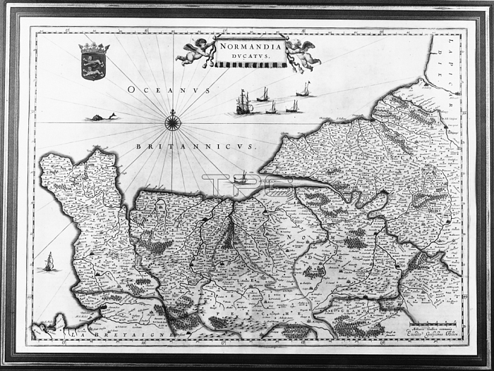
3518953 Map of Normandy after an illustration from Theatrum Orbis Terrarum sive Atlas Novus by Willem and Joan Blaeu, plate representing Normandia Ducatus (Normandy: Calvados, Manche, Orne, Eure, Seine-Maritime), published in 1635, 18th century (engraving) by Blaeu, Willem (1571-1638) and Joan (1596-1673) (after); 40 x 54.5 cm; Private Collection; Photo 穢 Christie\'s Images.
| px | px | dpi | = | cm | x | cm | = | MB |
Details
Creative#:
TOP27576243
Source:
達志影像
Authorization Type:
RM
Release Information:
須由TPG 完整授權
Model Release:
No
Property Release:
No
Right to Privacy:
No
Same folder images:
coastcoastlineshorelinecoastalseamaritimecartographyshipshipscoastlinescoastlinecoatofarmschartsfrenchgeogrpahicchartcoastsmapsmapgeographynormandyenglishchannelatlasnovustheatrumorbisterrarumfranceshipshipscoastlinescoastlinecoatofarmschartsfrenchgeogrpahicchartcoastsmapsmapgeographynormandyenglishchannelcoastatlasnovustheatrumorbisterrarumfrance
armsarmsatlasatlascartographychannelchannelchartchartchartschartscoastcoastcoastalcoastlinecoastlinecoastlinecoastlinescoastlinescoastscoastscoatcoatenglishenglishfrancefrancefrenchfrenchgeographygeographygeogrpahicgeogrpahicmapmapmapsmapsmaritimenormandynormandynovusnovusofoforbisorbisseashipshipshipsshipsshorelineterrarumterrarumtheatrumtheatrum
 Loading