
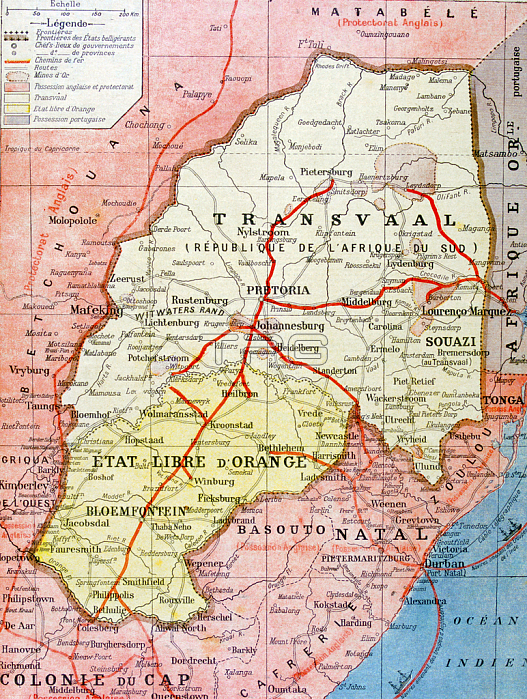
3479681 French map of the Transvaal at the outbreak of the Boer War in South Africa, 1899; Universal History Archive/UIG; out of copyright.
| px | px | dpi | = | cm | x | cm | = | MB |
Details
Creative#:
TOP27536576
Source:
達志影像
Authorization Type:
RM
Release Information:
須由TPG 完整授權
Model Release:
No
Property Release:
No
Right to Privacy:
No
Same folder images:
19thcentury19centuryXIXcenturyXIXthcenturyNineteenthCenturyc19th19XIXexixxixesiecle19nineteenthnineteenthnineteenthcenturySouthAfricaAfricaafricanafricansafricaafricanafricansoutbreakepidemicEpidemiapandemycontagionillnesssickdiseasesicknessmedicinemedicalhealthFrancefrencheuropeanunionEUEuropeeuropeanBoerWar(1899-1902)warmap1890ssouthafricaoutbreakfrench19thcenturymapboerwartransvaalsouthafricaoutbreakfrench19thcenturymapboerwartransvaal
(1899-1902)1890s19191919th19th19thAfricaAfricaBoerCenturyEUEpidemiaEuropeFranceNineteenthSouthWarXIXXIXeXIXthafricaafricaafricaafricanafricanafricansafricansboerboerc19thcenturycenturycenturycenturycenturycenturycenturycontagiondiseaseepidemiceuropeaneuropeanfrenchfrenchfrenchhealthillnessmapmapmapmedicalmedicinenineteenthnineteenthnineteenthoutbreakoutbreakoutbreakpandemysicksicknesssieclesouthsouthtransvaaltransvaalunionwarwarwarxixxixe
 Loading