
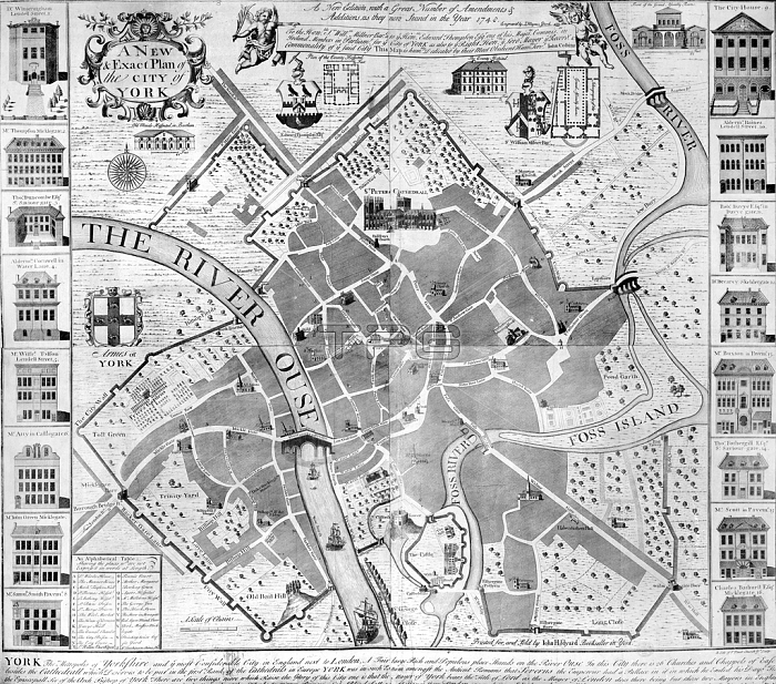
3058203 A New and Exact Plan of the City of York, 1748 (engraving) by English School, (18th century); Private Collection; (add.info.: 2nd edition of John Cossin\'s map first printed in 1727 and sold by subscription.).
| px | px | dpi | = | cm | x | cm | = | MB |
Details
Creative#:
TOP27510070
Source:
達志影像
Authorization Type:
RM
Release Information:
須由TPG 完整授權
Model Release:
No
Property Release:
No
Right to Privacy:
No
Same folder images:
castlecastlesdwellinghousingaccomodationfashionfashionablefashionscartographycityriverriversmicklegatehousessecularfossenglandcitywallgeorgiancastlegatehospitalassemblyhousesurveystreetspavementarchitecturemapbuildingscitymapcitygatepublichousingcathedralwalledcitystsaviourgateouseskeldergateyorkminsteryorkplanminsteryorkshireposterncastlecityriverriversmicklegatehousessecularfossenglandcitywallgeorgiancastlegatehospitalassemblyhousefashionablesurveystreetspavementarchitecturemapbuildingscitymapcitygatepublichousingcathedralwalledcitystsaviourgateouseskeldergateyorkminsteryorkplanminsteryorkshirepostern
accomodationarchitecturearchitectureassemblyassemblybuildingsbuildingscartographycastlecastlecastlegatecastlegatecastlescathedralcathedralcitycitycitycitycitycitycitycitycitycitydwellingenglandenglandfashionfashionablefashionablefashionsfossfossgategategeorgiangeorgianhospitalhospitalhousehousehouseshouseshousinghousinghousingmapmapmapmapmicklegatemicklegateminsterminsterminsterminsterouseousepavementpavementplanplanposternposternpublicpublicriverriverriversriverssaviourgatesaviourgatesecularsecularskeldergateskeldergatestststreetsstreetssurveysurveywallwallwalledwalledyorkyorkyorkyorkyorkshireyorkshire
 Loading