
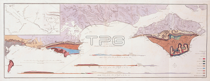
1765217 Geological Map and Sections of the Isle of Wight and the Adjacent Parts of Hampshire and Dorsetshire, 1816 (hand-coloured engraving) by Webster, Thomas (1772-1844) ; 40x76 cm; Society of Antiquaries of London, UK; (add.info.: Sir Henry Charles Englefield (c. 1752-1822) was President of the Society of Antiquaries of London in 1811. From 1811 to 1813 Webster worked on a commission for Englefield on the Isle of Wight, the result of which was the first hand-coloured geological map of the Isle of Wight and parts of Hampshire and Dorset.); English, out of copyright.
| px | px | dpi | = | cm | x | cm | = | MB |
Details
Creative#:
TOP27427905
Source:
達志影像
Authorization Type:
RM
Release Information:
須由TPG 完整授權
Model Release:
No
Property Release:
No
Right to Privacy:
No
Same folder images:
coastcoastlineshorelineseamaritimeisleofwightgeologyantiquarianenglandsouthwestmapsbritainbritishgeologicalwestcountryregencymapsoutheastengravingenglishsirhenrycharlesenglefielddorsetthomaswebsterhampshireEngravingMzengravinggeologyantiquarianenglandsouthwestmapsbritainbritishgeologicalwestcountryregencymapsoutheastcoastalengravingenglishcoastsirhenrycharlesenglefielddorsetthomaswebsterhampshire
EngravingMzengravingantiquarianantiquarianbritainbritainbritishbritishcharlescharlescoastcoastcoastalcoastlinecountrycountrydorsetdorseteasteastenglandenglandenglefieldenglefieldenglishenglishengravingengravinggeologicalgeologicalgeologygeologyhampshirehampshirehenryhenryislemapmapmapsmapsmaritimeofregencyregencyseashorelinesirsirsouthsouthsouthsouththomasthomaswebsterwebsterwestwestwestwestwight
 Loading