
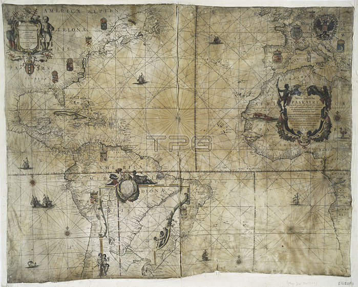
1765720 Territorial holdings of the Dutch West India Company, 1710 (hand coloured print on vellum) by Bleau, Guillaume & Jean (17th century); 77.3x95.2 cm; New York Public Library, USA; (add.info.: West India Company was incorporated in 1621. This is a late issue (published by Johannes van Kuelen) from the cartographer Willem Janszoon Bleau (1571-1638) and one of the first maps to show the Strait of Le Maire, Argentina, discovered in 1616. ); French, out of copyright.
| px | px | dpi | = | cm | x | cm | = | MB |
Details
Creative#:
TOP27427887
Source:
達志影像
Authorization Type:
RM
Release Information:
須由TPG 完整授權
Model Release:
No
Property Release:
No
Right to Privacy:
No
Same folder images:
coastcoastlineshorelineseamaritimecartographyhydrographyargentinadiscoverytradenetherlandslemairestraitseachartafricamaritimenauticalexplorationrhumblinesoceanseamapamericaeuropeamsterdamvellumnavigationhydrographyargentinadiscoverytradenetherlandslemairestraitseachartafricamaritimenauticalexplorationrhumblinesoceanseamapamericaeuropecoastamsterdamvellumnavigation
africaafricaamericaamericaamsterdamamsterdamargentinaargentinacartographychartchartcoastcoastcoastlinediscoverydiscoveryeuropeeuropeexplorationexplorationhydrographyhydrographylelelineslinesmairemairemapmapmaritimemaritimemaritimenauticalnauticalnavigationnavigationnetherlandsnetherlandsoceanoceanrhumbrhumbseaseaseaseaseashorelinestraitstraittradetradevellumvellum
 Loading