
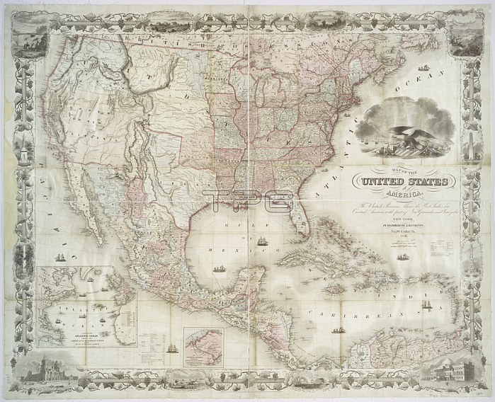
1765719 Map of the United States of America, British provinces, Mexico, West Indies and Central America, 1850 (hand coloured print) by American School, (19th century); 87x107 cm; New York Public Library, USA; (add.info.: Inset maps of the Atlantic Ocean showing the American & European ports and the routes of the ocean steamers and another of the Isthmus of Panama and pictures of Vallery of the Connecticut, Washington Capitol, Mexico Cathedral, Willammette Falls & Astoria in Oregon, Saratoga Lake in New York & various monuments. ); American, out of copyright.
| px | px | dpi | = | cm | x | cm | = | MB |
Details
Creative#:
TOP27427811
Source:
達志影像
Authorization Type:
RM
Release Information:
須由TPG 完整授權
Model Release:
No
Property Release:
No
Right to Privacy:
No
Same folder images:
coastcoastlineshorelinecoastalseamaritimeCaribbeanCarribeancartographyhydrographycaribbeancentralamericaislandsseachartmaritimebunkerhillcolonialamericanorthamericaoceancaribbeanseaseasouthamericamapatlanticoceanamericanamericagulfofmexicobattleunitedstatesbritishcolonywashingtonatlaspulaskipanamausaportbaltimorenavigationEngravingMzengravinghydrographycaribbeancentralamericaislandsseachartmaritimebunkerhillcolonialamericanorthamericaoceancaribbeanseaseasouthamericamapatlanticoceanamericanamericagulfofmexicobattleunitedstatesbritishcolonycoastwashingtonatlaspulaskipanamausaportbaltimorenavigation
CaribbeanCarribeanEngravingMzengravingamericaamericaamericaamericaamericaamericaamericaamericaamericaamericaamericanamericanatlanticatlanticatlasatlasbaltimorebaltimorebattlebattlebritishbritishbunkerbunkercaribbeancaribbeancaribbeancaribbeancartographycentralcentralchartchartcoastcoastcoastalcoastlinecolonialcolonialcolonycolonygulfgulfhillhillhydrographyhydrographyislandsislandsmapmapmaritimemaritimemaritimemexicomexiconavigationnavigationnorthnorthoceanoceanoceanoceanofofpanamapanamaportportpulaskipulaskiseaseaseaseaseaseaseashorelinesouthsouthstatesstatesunitedunitedusausawashingtonwashington
 Loading