
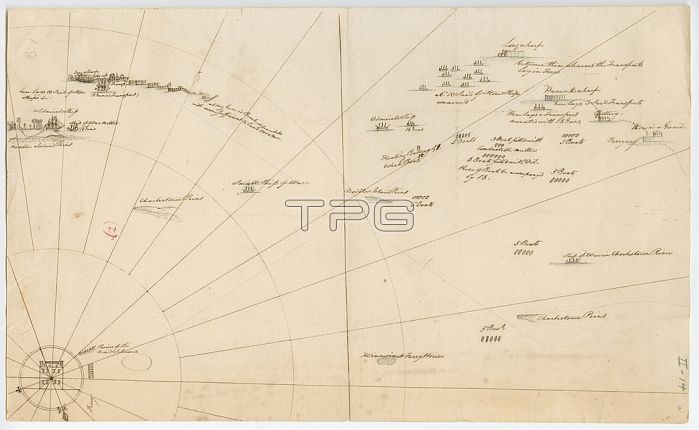
696026 Battle plan for the siege of Boston Harbour, c.1775-1776 (litho) by American School, (18th century); 32.6x19.7 cm; Gilder Lehrman Collection, New York, USA; (add.info.: Mapped battle plan for an American siege of Boston Harbor. Shows boats and some major geographic markers. ); 穢 Gilder Lehrman Institute of American History ; American, out of copyright.
| px | px | dpi | = | cm | x | cm | = | MB |
Details
Creative#:
TOP27142554
Source:
達志影像
Authorization Type:
RM
Release Information:
須由TPG 完整授權
Model Release:
No
Property Release:
No
Right to Privacy:
No
Same folder images:
18thcenturyXVIIIthcenturyXVIIIC18theighteenthcenturysecoloXVIII1818thxviiixviiithcentury1818th18th18th18th18thcenturycartographyshipshipswarfarepositionsnavalbattledrawingnavysketchmapssiegemappingmapthewarforindependenceharborseabattleusamericanrevolutionunitedstatesofamericausaplanmassachusettsEngravingMzengravingshipshipswarfarepositionsnavalbattledrawingnavysketchmapssiegemappingmapthewarforindependenceharborseabattlec18thusamericanrevolutionunitedstatesofamericausaplanmassachusetts
181818th18th18th18th18th18th18thC18thEngravingMzengravingXVIIIXVIIIXVIIIthamericaamericaamericanamericanbattlebattlebattlebattlec18thcartographycenturycenturycenturycenturycenturydrawingdrawingeighteenthforforharborharborindependenceindependencemapmapmappingmappingmapsmapsmassachusettsmassachusettsnavalnavalnavynavyofofplanplanpositionspositionsrevolutionrevolutionseaseasecoloshipshipshipsshipssiegesiegesketchsketchstatesstatesthetheunitedunitedusususausawarwarwarfarewarfarexviiixviiith
 Loading