
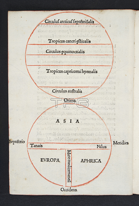
488665 Map and diagram of the world, folio a4v of \'Orbis Breviarium\' by Zaccaria Lilio (d.c.1522), Florence, 1493 (print & woodcut) by Italian School, (15th century); length: 22 cm; Glasgow University Library, Scotland; (add.info.: A compendium of geographical information taken from a large number of classical sources. The material is arranged in alphabetical dictionary fashion. The author was the first to condense the writings of the ancient and medieval geographers into one work. T. Campbell describes the two so-called maps as follows in \'The earliest printed maps\', 1987, p. 112: "Interest today lies largely in the methods used to print the Lilio map [fol. a4v]. While its ten names--comprising the cardinal points, the three continents and the three main waterways of the ancient world--are supplied in type, the ... outlines themselves are printed in red from a woodblock. This gives the map the narrow technical distinction of being the first to be printed in more than one colour. Immediately above the map is a diagram showing the division of the world into six zones, and later in the volume [fol. q5r] there follows a half circle with nine climatic zones. Since no geographical outlines are included on either, these fall short of our minimum definition of a map ..." ); 穢 University of Glasgow Library ; Italian, out of copyright.
| px | px | dpi | = | cm | x | cm | = | MB |
Details
Creative#:
TOP27080188
Source:
達志影像
Authorization Type:
RM
Release Information:
須由TPG 完整授權
Model Release:
No
Property Release:
No
Right to Privacy:
No
Same folder images:
 Loading