
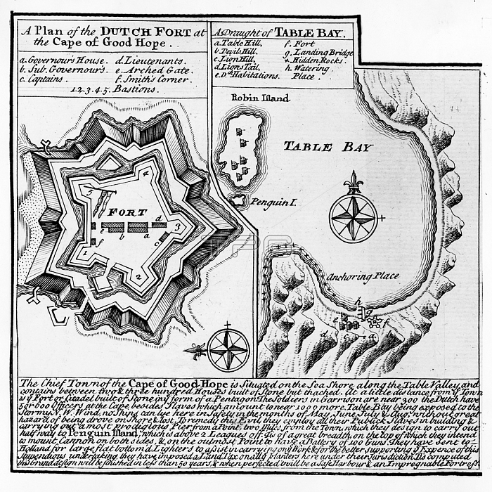
XJF437999 A Plan of the Dutch Fort at the Cape of Good Hope and A Draught of Table Bay (engraving) by English School, (18th century); Private Collection; (add.info.: A Plan of the star fort, also known as the Castle of Good Hope, that the Dutch East India Company built between 1666 and 1679; This fortified stone structure was built as a result of the agitations with the British, replacing an earlier wooden stucture that had been built to serve as a as a replenishment station for ships passing the treacherous Cape on the long voyage between the Netherlands and the Dutch East Indies; The draught of Table Bay shows Robben Island, that was used to isolate political prisoners and notes the location of Good Hope Castle as well as Table Mountain; The accompanying inscription tells of a plan to build a protective pier between the main land and Penguin Island in order to provide more shelter for ships anchored in the bay, as well as plans for further fortifications;); English, out of copyright.
| px | px | dpi | = | cm | x | cm | = | MB |
Details
Creative#:
TOP27067915
Source:
達志影像
Authorization Type:
RM
Release Information:
須由TPG 完整授權
Model Release:
No
Property Release:
No
Right to Privacy:
No
Same folder images:
 Loading