
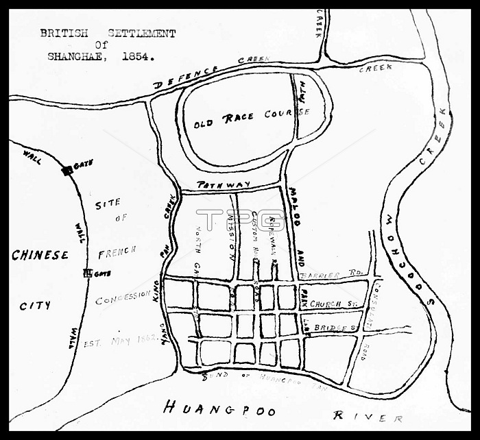
This map, which was drawn in the mid-1930s, shows the outline of the British Settlement (which would become the heart of the International Settlement) in relation to the Chinese City (Nanshi), the Huangpu River and Suzhou Creek, in 1854. International attention to Shanghai grew in the 19th century due to its economic and trade potential near the mouth of the Yangtze River. During the First Opium War (18391842), British forces temporarily held the city. The war ended with the 1842 Treaty of Nanjing, opening the treaty ports, Shanghai included, for international trade. The Treaty of the Bogue signed in 1843, and the Sino-American Treaty of Wangsia signed in 1844 together allowed foreign nations to visit and trade on Chinese soil, the start of the foreign concessions. In 1854, the Shanghai Municipal Council was created to manage the foreign settlements. In 18601862, during a civil war Shanghai had been invaded twice. In 1863, the British settlement, located to the south of Suzhou creek (Huangpu district), and the American settlement, to the north of Suzhou creek (Hongkou district), joined in order to form the International Settlement.
| px | px | dpi | = | cm | x | cm | = | MB |
Details
Creative#:
TOP27037749
Source:
達志影像
Authorization Type:
RM
Release Information:
須由TPG 完整授權
Model Release:
No
Property Release:
No
Right to Privacy:
No
Same folder images:
 Loading