
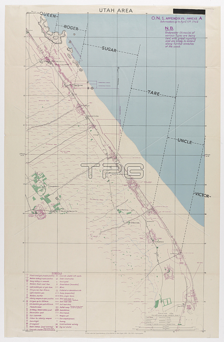
NAM244263 Utah Area, one of five maps illustrating the nature of German land defences along the shoreline of the D-Day landings, 1944 (colour litho) by Edgell, John (d.1963); National Army Museum, London; 穢 National Army Museum ; English, out of copyright.
| px | px | dpi | = | cm | x | cm | = | MB |
Details
Creative#:
TOP26961364
Source:
達志影像
Authorization Type:
RM
Release Information:
須由TPG 完整授權
Model Release:
No
Property Release:
No
Right to Privacy:
No
Same folder images:
coastcoastlineshorelineseamaritimecoastlineutahbeachmilitaryoffensivefrenchtwodefencessecondbeachesdefenceddaylanding2ndmapnormandyworldwartwolandingsoperationoverlordoperationssecondworldwargermaniiww2wwiifranceutahbeachmilitaryoffensivefrenchtwodefencessecondbeachesdefenceddaylanding2ndmapnormandyworldwartwolandingscoastaloperationoverlordoperationssecondworldwargermancoastiiww2wwiifrance
2nd2ndbeachbeachbeachesbeachescoastcoastcoastalcoastlinecoastlinedddaydaydefencedefencedefencesdefencesfrancefrancefrenchfrenchgermangermaniiiilandinglandinglandingslandingsmapmapmaritimemilitarymilitarynormandynormandyoffensiveoffensiveoperationoperationoperationsoperationsoverlordoverlordseasecondsecondsecondsecondshorelinetwotwotwotwoutahutahwarwarwarwarworldworldworldworldww2ww2wwiiwwii
 Loading