
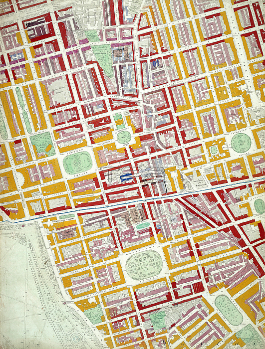
MOL384783 Descriptive map of London Poverty, 1889 (hand-coloured litho) by English School, (19th century); Museum of London, UK; (add.info.: compiled and coloured by Charles Booth and assistants; this section covers the area between Upper Gloucester Place, Charlotte Street, Hay Hill and Hyde Park;); 穢 Museum of London ; English, out of copyright.
| px | px | dpi | = | cm | x | cm | = | MB |
Details
Creative#:
TOP26919951
Source:
達志影像
Authorization Type:
RM
Release Information:
須由TPG 完整授權
Model Release:
No
Property Release:
No
Right to Privacy:
No
Same folder images:
statisticStatisticsStatisticalanalysisurbanpovertydividecoloursstatisticcolourcodedgraphaveragechartsocialvisualrepresentationeconomicfinancewealthdistributionstatisticsdiscriminationaffluencecolourkeysohoEngravingMzengravingpovertydividecoloursstatisticcolourcodedgraphaveragechartsocialvisualrepresentationeconomicfinancewealthdistributionstatisticsdiscriminationaffluencecolourkeysoho
EngravingMzengravingStatisticalStatisticsaffluenceaffluenceanalysisaverageaveragechartchartcodedcodedcolourcolourcolourcolourcolourscoloursdiscriminationdiscriminationdistributiondistributiondividedivideeconomiceconomicfinancefinancegraphgraphkeykeypovertypovertyrepresentationrepresentationsocialsocialsohosohostatisticstatisticstatisticstatisticsstatisticsurbanvisualvisualwealthwealth
 Loading