
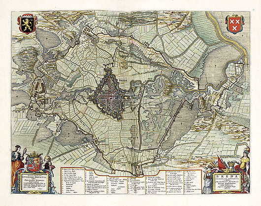
Map of Breda, 17th century. This fortified city, located in the province of North Brabant in the Dutch Republic, lies at the confluence of the Mark and Aa rivers. This city was of strategic importance in the 17th century. The coat-of-arms is at top right. This map is from 'Toonneel der steden van de Vereenighde Nederlanden' (1652), an atlas of maps of the cities and towns of the United Provinces of the Netherlands, published by Dutch cartographer Joan Blau (1596-1673).
| px | px | dpi | = | cm | x | cm | = | MB |
Details
Creative#:
TOP26515749
Source:
達志影像
Authorization Type:
RM
Release Information:
須由TPG 完整授權
Model Release:
N/A
Property Release:
N/A
Right to Privacy:
No
Same folder images:
1600scartographicgeographicalhistoricalno-onenobodytoonneelderstedenvandevereenighdenederlandenjoanblaudutcheuropeanunitedprovincesofthenetherlandsdutchgoldenagerivermarkriveraafortifiedcitycoatofarmscoat-of-armsbredamaptowncitynetherlandsnorthbrabanteuropegeographyhistorycartographyprintedtext17thcentury1652
1600s165217thaaagearmsblaubrabantbredacartographiccartographycenturycitycitycoatcoat-of-armsdederdutchdutcheuropeeuropeanfortifiedgeographicalgeographygoldenhistoricalhistoryjoanmapmarknederlandennetherlandsnetherlandsno-onenobodynorthofofprintedprovincesriverriverstedentextthetoonneeltownunitedvanvereenighde
 Loading