
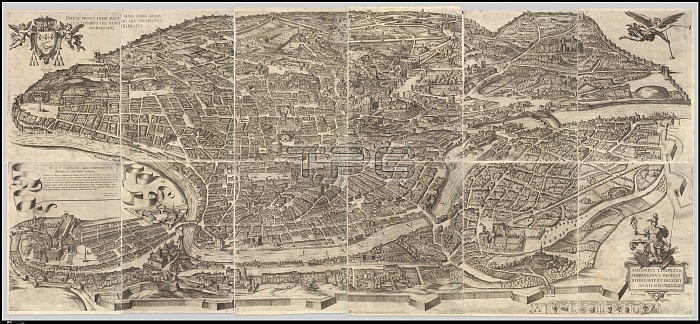
Plan of the City of Rome, 1645, Etching with some engraving, undescribed state (printed from 12 plates), Overall: 41 5/16 x 94 1/2 in. (105 x 240 cm), Prints, Antonio Tempesta (Italian, Florence 1555?1630 Rome), Plan or aerial view of the city of Rome, taken from the north-west. The map shows Rome in its late sixteenth-century condition. The map was first printed in 1593. This edition with changes dates to 1645
| px | px | dpi | = | cm | x | cm | = | MB |
Details
Creative#:
TOP26311078
Source:
達志影像
Authorization Type:
RM
Release Information:
須由TPG 完整授權
Model Release:
No
Property Release:
No
Right to Privacy:
No
Same folder images:
1555159316301645aerialagedantoniocenturychangescityconditionconditionsdatesdrawingdrawingseditionengravingengravingsetchingetchingsfirstflorencehistorichistoricalhistoricallyhistoryillustrationillustrationsitalianlatemapnortholdoverallpaintedpaintingpicturepicturesplanplatesprintedprintsromesixteenthstatetempestaundescribedviewwestalimdiRM333DYYSM
1555159316301645333DYYSMRMaerialagedalimdiantoniocenturychangescityconditionconditionsdatesdrawingdrawingseditionengravingengravingsetchingetchingsfirstflorencehistorichistoricalhistoricallyhistoryillustrationillustrationsitalianlatemapnortholdoverallpaintedpaintingpicturepicturesplanplatesprintedprintsromesixteenthstatetempestaundescribedviewwest
 Loading